San Rafael del Norte elevation
San Rafael del Norte (Jinotega, Municipio de San Rafael del Norte), Nicaragua elevation is 1081 meters and San Rafael del Norte elevation in feet is 3547 ft above sea level [src 1]. San Rafael del Norte is a seat of a second-order administrative division (feature code) with elevation that is 740 meters (2428 ft) bigger than average city elevation in Nicaragua.
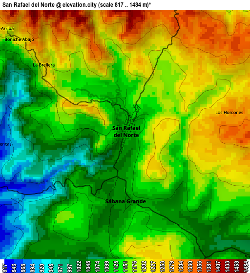
Below is the Elevation map of San Rafael del Norte, which displays elevation range with different colors. Scale of the first map is from 817 to 1484 m (2680 to 4869 ft) with average elevation of 1140.6 meters (=3742 ft) [note 1]
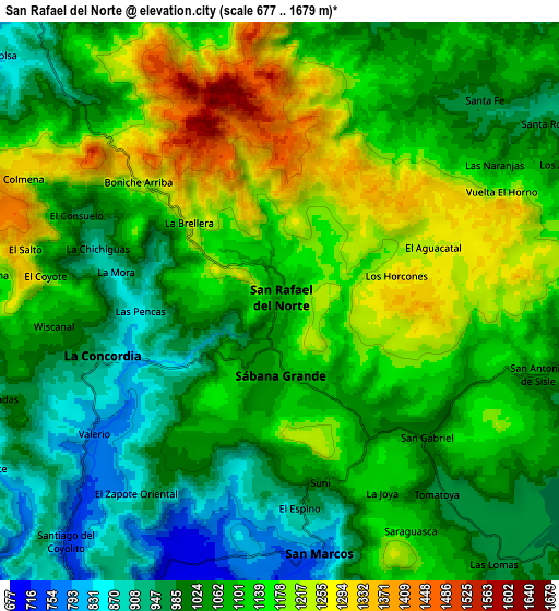
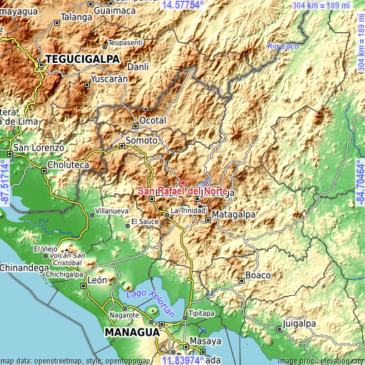
These maps also provides idea of topography and contour of this city, they are displayed at different zoom levels. More info about maps, scale and edge coordinates you can find below images.
| \ | Map #1 | Map #2 | Topo.Map |
| Scale [m] | 817..1484 m | 677..1679 m | × |
| Scale [ft] | 2680..4869 ft | 2221..5509 ft | × |
| Average | 1140.6 m = 3742 ft | 1090.7 m = 3578 ft | × |
| Width | 9.51 km = 5.9 mi | 19.03 km = 11.8 mi | 304.4 km = 189.1 mi |
| Height | 9.51 km = 5.9 mi | 19.03 km = 11.8 mi | 304.4 km = 189.1 mi |
| ↑Max Latitude | 13.255258° | 13.298029° | 14.57754° |
| Latitude at center | 13.21248° | 13.21248° | 13.21248° |
| ↓Min Latitude | 13.169694° | 13.126901° | 11.83974° |
| ← Min Longitude | -86.154835° | -86.198781° | -87.51714° |
| Longitude center | -86.11089° | -86.11089° | -86.11089° |
| →Max Longitude | -86.066945° | -86.022999° | -84.70464° |
Nearby cities:
Cities around San Rafael del Norte sort by population:
• Matagalpa elevation 686 m
38.2 km,  146°
146°
• Estelí 840 m
29.5 km,  242°
242°
• Jinotega 1020 m
17.9 km,  138°
138°
• Condega 559 m
35.4 km,  298°
298°
• Las Praderas 1009 m
28.6 km,  99°
99°
• San Sebastián de Yalí 855 m
13.2 km,  321°
321°
• San Juan de Río Coco 822 m
37.4 km,  350°
350°
• La Concordia 901 m
6.3 km,  252°
252°
• LLano de La Cruz 980 m
14.8 km,  131°
131°
• San Isidro 484 m
32.8 km,  196°
196°
• La Trinidad 611 m
30.3 km,  206°
206°
• Santa Maía de Pantasma 404 m
23.5 km,  50°
50°
Multilingual:
 En español:
San Rafael del Norte elevación 1081 m.
 En France:
San Rafael del Norte élévation 1081 m.
 Auf Deutsch:
San Rafael del Norte höhe über dem Meeresspiegel ist 1081 m.
 На русском:
San Rafael del Norte высота над уровнем моря 1081 м
Sources and notes:
- [note 1] Map square and city borders are not equal. Map elevation data is calculated only from area inside that square.
- [src 1] Elevation data from geonames database provided with same terms of usage.
- [src 2] The elevation map of San Rafael del Norte is generated using elevation data from NASA's 3 arcsec (90m) resolution SRTM data.
- [src 3] Base (background) map © OpenStreetMap contributors tiles are generated by Geofabrik and OpenTopoMap.
Copyright & License:
This San Rafael del Norte Elevation Map is licensed under CC BY-SA. You may reuse any part from this page, if you give a proper credit by linking to this URL:
 More info on terms of use page.