Matagalpa elevation
Matagalpa, Nicaragua elevation is 686 meters and Matagalpa elevation in feet is 2251 ft above sea level [src 1]. Matagalpa is a seat of a first-order administrative division (feature code) with elevation that is 345 meters (1132 ft) bigger than average city elevation in Nicaragua.
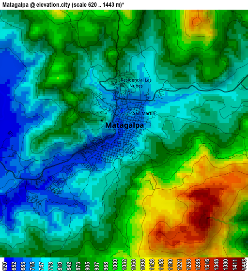
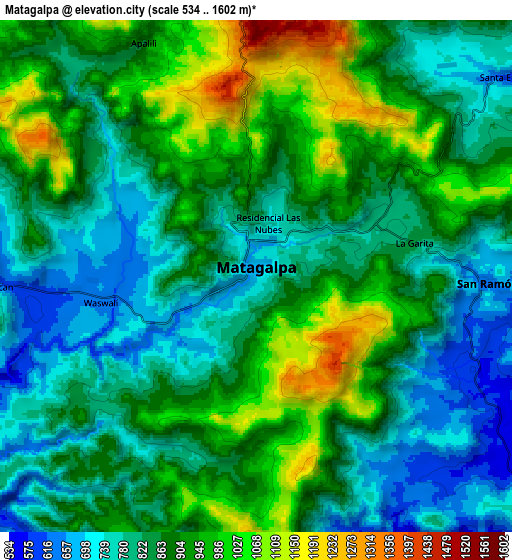
Below is the Elevation map of Matagalpa, which displays elevation range with different colors. Scale of the first map is from 620 to 1443 m (2034 to 4734 ft) with average elevation of 883.8 meters (=2900 ft) [note 1]
These maps also provides idea of topography and contour of this city, they are displayed at different zoom levels. More info about maps, scale and edge coordinates you can find below images.
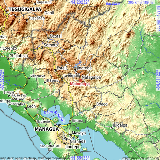
| \ | Map #1 | Map #2 | Topo.Map |
| Scale [m] | 620..1443 m | 534..1602 m | × |
| Scale [ft] | 2034..4734 ft | 1752..5256 ft | × |
| Average | 883.8 m = 2900 ft | 870.2 m = 2855 ft | × |
| Width | 9.52 km = 5.9 mi | 19.05 km = 11.8 mi | 304.8 km = 189.4 mi |
| Height | 9.52 km = 5.9 mi | 19.05 km = 11.8 mi | 304.8 km = 189.4 mi |
| ↑Max Latitude | 12.968418° | 13.011239° | 14.29232° |
| Latitude at center | 12.92559° | 12.92559° | 12.92559° |
| ↓Min Latitude | 12.882755° | 12.839912° | 11.55133° |
| ← Min Longitude | -85.961415° | -86.005361° | -87.32372° |
| Longitude center | -85.91747° | -85.91747° | -85.91747° |
| →Max Longitude | -85.873525° | -85.829579° | -84.51122° |
Nearby cities:
Cities around Matagalpa sort by population:
• Jinotega elevation 1020 m
20.6 km,  333°
333°
• Ciudad Darío 456 m
31.1 km,  226°
226°
• Las Praderas 1009 m
28.1 km,  15°
15°
• San Dionisio 383 m
19.8 km,  158°
158°
• San Ramón 639 m
8.5 km,  91°
91°
• Terrabona 538 m
22.3 km,  193°
193°
• LLano de La Cruz 980 m
24.2 km,  336°
336°
• La Trinidad 611 m
34.8 km,  277°
277°
• Esquipulas 522 m
32.3 km,  154°
154°
• La Dalia 741 m
30.5 km,  39°
39°
• San Isidro 484 m
30.1 km,  270°
270°
• Sébaco 475 m
21 km,  247°
247°
Multilingual:
 En español:
Matagalpa elevación 686 m.
 En France:
Matagalpa élévation 686 m.
 Auf Deutsch:
Matagalpa höhe über dem Meeresspiegel ist 686 m.

Sources and notes:
- [note 1] Map square and city borders are not equal. Map elevation data is calculated only from area inside that square.
- [src 1] Elevation data from geonames database provided with same terms of usage.
- [src 2] The elevation map of Matagalpa is generated using elevation data from NASA's 3 arcsec (90m) resolution SRTM data.
- [src 3] Base (background) map © OpenStreetMap contributors tiles are generated by Geofabrik and OpenTopoMap.
Copyright & License:
This Matagalpa Elevation Map is licensed under CC BY-SA. You may reuse any part from this page, if you give a proper credit by linking to this URL:
 More info on terms of use page.