Aba elevation
Aba (Abia, Aba South), Nigeria elevation is 64 meters and Aba elevation in feet is 210 ft above sea level [src 1]. Aba is a seat of a second-order administrative division (feature code) with elevation that is 233 meters (764 ft) smaller than average city elevation in Nigeria.
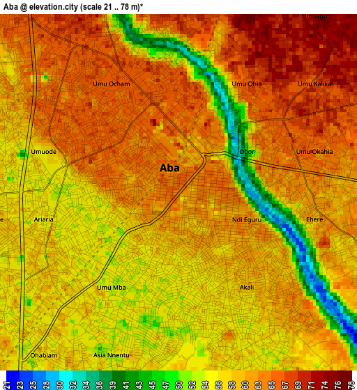
Below is the Elevation map of Aba, which displays elevation range with different colors. Scale of the first map is from 21 to 78 m (69 to 256 ft) with average elevation of 59.5 meters (=195 ft) [note 1]
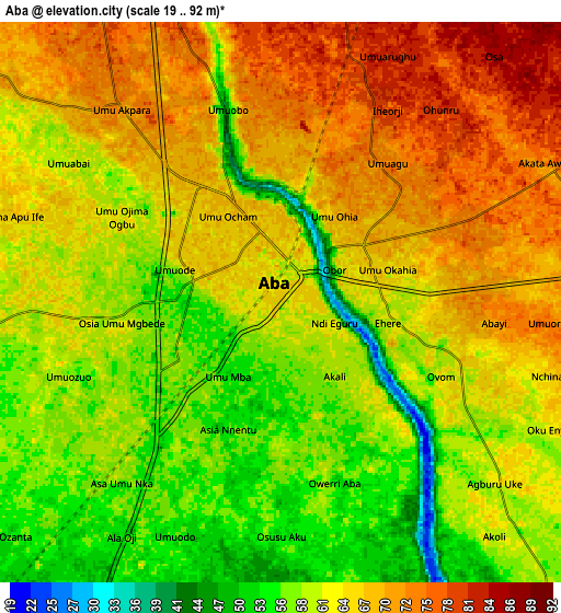
These maps also provides idea of topography and contour of this city, they are displayed at different zoom levels. More info about maps, scale and edge coordinates you can find below images.
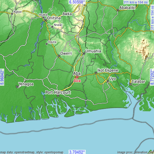
| \ | Map #1 | Map #2 | Topo.Map |
| Scale [m] | 21..78 m | 19..92 m | × |
| Scale [ft] | 69..256 ft | 62..302 ft | × |
| Average | 59.5 m = 195 ft | 63 m = 207 ft | × |
| Width | 9.73 km = 6 mi | 19.47 km = 12.1 mi | 311.4 km = 193.5 mi |
| Height | 9.73 km = 6 mi | 19.47 km = 12.1 mi | 311.5 km = 193.6 mi |
| ↑Max Latitude | 5.150349° | 5.194116° | 6.50558° |
| Latitude at center | 5.10658° | 5.10658° | 5.10658° |
| ↓Min Latitude | 5.062808° | 5.019032° | 3.70452° |
| ← Min Longitude | 7.322725° | 7.278779° | 5.96042° |
| Longitude center | 7.36667° | 7.36667° | 7.36667° |
| →Max Longitude | 7.410615° | 7.454561° | 8.77292° |
Nearby cities:
Cities around Aba sort by population:
• Ikot Akpa Nkuk elevation 37 m
34 km,  139°
139°
• Afaha Ikot Ebak 88 m
32.2 km,  86°
86°
• Utu Etim Ekpo 55 m
29.3 km,  112°
112°
• Nto Edino 75 m
28.6 km,  54°
54°
• Okpuala-Ngwa 118 m
28 km,  4°
4°
• Okehi 51 m
25.5 km,  278°
278°
• Akwete 16 m
24.5 km,  182°
182°
• Oke-Ikpe 23 m
22.2 km,  193°
193°
• Urua Inyang 65 m
21.2 km,  115°
115°
• Omoba 98 m
15.8 km,  16°
16°
• Eberi 55 m
14.8 km,  263°
263°
• Osisioma 71 m
7.7 km,  320°
320°
Multilingual:
 En español:
Aba elevación 64 m.
 En France:
Aba élévation 64 m.


Sources and notes:
- [note 1] Map square and city borders are not equal. Map elevation data is calculated only from area inside that square.
- [src 1] Elevation data from geonames database provided with same terms of usage.
- [src 2] The elevation map of Aba is generated using elevation data from NASA's 3 arcsec (90m) resolution SRTM data.
- [src 3] Base (background) map © OpenStreetMap contributors tiles are generated by Geofabrik and OpenTopoMap.
Copyright & License:
This Aba Elevation Map is licensed under CC BY-SA. You may reuse any part from this page, if you give a proper credit by linking to this URL:
 More info on terms of use page.