Anchau elevation
Anchau (Kaduna, Kuban), Nigeria elevation is 691 meters and Anchau elevation in feet is 2267 ft above sea level [src 1]. Anchau is a seat of a second-order administrative division (feature code) with elevation that is 394 meters (1293 ft) bigger than average city elevation in Nigeria.
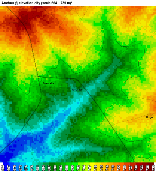
Below is the Elevation map of Anchau, which displays elevation range with different colors. Scale of the first map is from 664 to 739 m (2178 to 2425 ft) with average elevation of 698.9 meters (=2293 ft) [note 1]
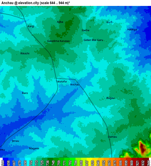
These maps also provides idea of topography and contour of this city, they are displayed at different zoom levels. More info about maps, scale and edge coordinates you can find below images.
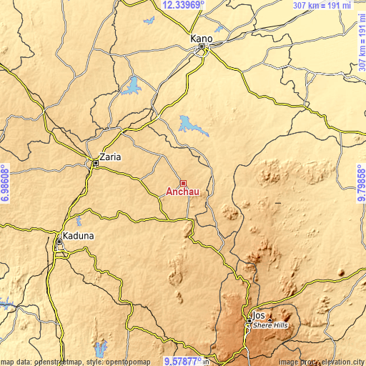
| \ | Map #1 | Map #2 | Topo.Map |
| Scale [m] | 664..739 m | 644..944 m | × |
| Scale [ft] | 2178..2425 ft | 2113..3097 ft | × |
| Average | 698.9 m = 2293 ft | 702 m = 2303 ft | × |
| Width | 9.59 km = 6 mi | 19.19 km = 11.9 mi | 307 km = 190.8 mi |
| Height | 9.59 km = 6 mi | 19.19 km = 11.9 mi | 307 km = 190.8 mi |
| ↑Max Latitude | 11.00559° | 11.048724° | 12.33969° |
| Latitude at center | 10.96245° | 10.96245° | 10.96245° |
| ↓Min Latitude | 10.919303° | 10.876151° | 9.57877° |
| ← Min Longitude | 8.348385° | 8.304439° | 6.98608° |
| Longitude center | 8.39233° | 8.39233° | 8.39233° |
| →Max Longitude | 8.436275° | 8.480221° | 9.79858° |
Nearby cities:
Cities around Anchau sort by population:
• Lere elevation 753 m
67.1 km,  162°
162°
• Dutsen Wai 694 m
24.5 km,  239°
239°
• Rano 526 m
69.2 km,  17°
17°
• Soba 683 m
36.6 km,  273°
273°
• Burumburum 603 m
59.8 km,  37°
37°
• Dan Gora 576 m
68.8 km,  337°
337°
• Saminaka 765 m
69.2 km,  152°
152°
• Kauru 649 m
50.4 km,  211°
211°
• Maigana 658 m
50.1 km,  278°
278°
• Ririwai 890 m
45.4 km,  122°
122°
• Tudun Wada 593 m
31.8 km,  1°
1°
• Ikara 667 m
29.9 km,  322°
322°
Multilingual:
 En español:
Anchau elevación 691 m.
 En France:
Anchau élévation 691 m.


Sources and notes:
- [note 1] Map square and city borders are not equal. Map elevation data is calculated only from area inside that square.
- [src 1] Elevation data from geonames database provided with same terms of usage.
- [src 2] The elevation map of Anchau is generated using elevation data from NASA's 3 arcsec (90m) resolution SRTM data.
- [src 3] Base (background) map © OpenStreetMap contributors tiles are generated by Geofabrik and OpenTopoMap.
Copyright & License:
This Anchau Elevation Map is licensed under CC BY-SA. You may reuse any part from this page, if you give a proper credit by linking to this URL:
 More info on terms of use page.