Arochukwu elevation
Arochukwu (Abia), Nigeria elevation is 82 meters and Arochukwu elevation in feet is 269 ft above sea level [src 1]. Arochukwu is a seat of a second-order administrative division (feature code) with elevation that is 215 meters (705 ft) smaller than average city elevation in Nigeria.
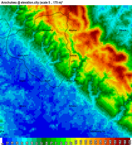
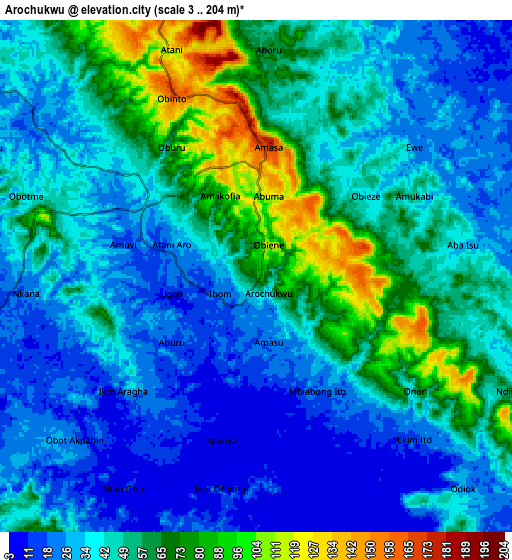
Below is the Elevation map of Arochukwu, which displays elevation range with different colors. Scale of the first map is from 5 to 175 m (16 to 574 ft) with average elevation of 57.5 meters (=189 ft) [note 1]
These maps also provides idea of topography and contour of this city, they are displayed at different zoom levels. More info about maps, scale and edge coordinates you can find below images.
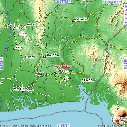
| \ | Map #1 | Map #2 | Topo.Map |
| Scale [m] | 5..175 m | 3..204 m | × |
| Scale [ft] | 16..574 ft | 10..669 ft | × |
| Average | 57.5 m = 189 ft | 44.8 m = 147 ft | × |
| Width | 9.73 km = 6 mi | 19.46 km = 12.1 mi | 311.3 km = 193.4 mi |
| Height | 9.73 km = 6 mi | 19.46 km = 12.1 mi | 311.3 km = 193.4 mi |
| ↑Max Latitude | 5.433159° | 5.476906° | 6.78769° |
| Latitude at center | 5.38941° | 5.38941° | 5.38941° |
| ↓Min Latitude | 5.345657° | 5.301902° | 3.9879° |
| ← Min Longitude | 7.868405° | 7.824459° | 6.5061° |
| Longitude center | 7.91235° | 7.91235° | 7.91235° |
| →Max Longitude | 7.956295° | 8.000241° | 9.3186° |
Nearby cities:
Cities around Arochukwu sort by population:
• Uyo elevation 45 m
37.7 km,  176°
176°
• Ikot Ekpene 89 m
31.8 km,  223°
223°
• Bende 123 m
36.1 km,  301°
301°
• Ohafia-Ifigh 124 m
27.4 km,  336°
336°
• Itu 32 m
22.4 km,  159°
159°
• Nto Edino 75 m
40.1 km,  248°
248°
• Isiala Oboro 141 m
38.1 km,  272°
272°
• Akpet Central 113 m
33.2 km,  39°
39°
• Ebem Ohafia 172 m
28.4 km, 341°
• Ibiaku Ntok Okpo 129 m
24 km, 248°
• Oko Ita 66 m
22 km, 184°
• Odoro Ikpe 121 m
18.1 km,  259°
259°
Multilingual:
 En español:
Arochukwu elevación 82 m.
 En France:
Arochukwu élévation 82 m.
 Auf Deutsch:
Arochukwu höhe über dem Meeresspiegel ist 82 m.

Sources and notes:
- [note 1] Map square and city borders are not equal. Map elevation data is calculated only from area inside that square.
- [src 1] Elevation data from geonames database provided with same terms of usage.
- [src 2] The elevation map of Arochukwu is generated using elevation data from NASA's 3 arcsec (90m) resolution SRTM data.
- [src 3] Base (background) map © OpenStreetMap contributors tiles are generated by Geofabrik and OpenTopoMap.
Copyright & License:
This Arochukwu Elevation Map is licensed under CC BY-SA. You may reuse any part from this page, if you give a proper credit by linking to this URL:
 More info on terms of use page.