Ugbokpo elevation
Ugbokpo (Benue, Apa), Nigeria elevation is 138 meters and Ugbokpo elevation in feet is 453 ft above sea level [src 1]. Ugbokpo is a seat of a second-order administrative division (feature code) with elevation that is 159 meters (522 ft) smaller than average city elevation in Nigeria.
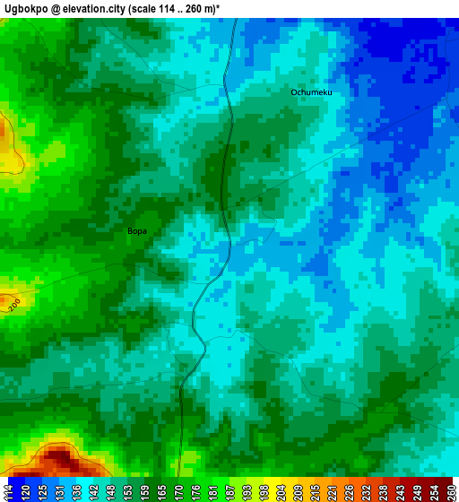
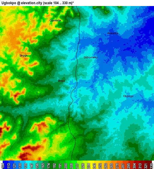
Below is the Elevation map of Ugbokpo, which displays elevation range with different colors. Scale of the first map is from 114 to 260 m (374 to 853 ft) with average elevation of 152.3 meters (=500 ft) [note 1]
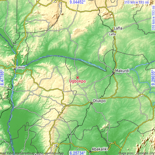
These maps also provides idea of topography and contour of this city, they are displayed at different zoom levels. More info about maps, scale and edge coordinates you can find below images.
| \ | Map #1 | Map #2 | Topo.Map |
| Scale [m] | 114..260 m | 104..330 m | × |
| Scale [ft] | 374..853 ft | 341..1083 ft | × |
| Average | 152.3 m = 500 ft | 172.6 m = 566 ft | × |
| Width | 9.69 km = 6 mi | 19.37 km = 12 mi | 309.9 km = 192.6 mi |
| Height | 9.69 km = 6 mi | 19.37 km = 12 mi | 309.9 km = 192.6 mi |
| ↑Max Latitude | 7.696762° | 7.740309° | 9.04452° |
| Latitude at center | 7.65321° | 7.65321° | 7.65321° |
| ↓Min Latitude | 7.609654° | 7.566093° | 6.25734° |
| ← Min Longitude | 7.840155° | 7.796209° | 6.47785° |
| Longitude center | 7.8841° | 7.8841° | 7.8841° |
| →Max Longitude | 7.928045° | 7.971991° | 9.29035° |
Nearby cities:
Cities around Ugbokpo sort by population:
• Makurdi elevation 92 m
70.8 km,  82°
82°
• Otukpa 417 m
66.1 km,  201°
201°
• Ankpa 334 m
39.4 km,  224°
224°
• Boju 215 m
33.1 km,  178°
178°
• Aliade 161 m
77 km,  121°
121°
• Bugana 89 m
50.7 km,  319°
319°
• Ochobo 127 m
53.7 km,  168°
168°
• Okpoga 193 m
68.7 km,  186°
186°
• Okpo 362 m
60.3 km, 216°
• Abejukolo 109 m
47.7 km,  300°
300°
• Naka 159 m
36.1 km,  102°
102°
• Obagaji 72 m
26.7 km,  5°
5°
Multilingual:
 En español:
Ugbokpo elevación 138 m.
 En France:
Ugbokpo élévation 138 m.


Sources and notes:
- [note 1] Map square and city borders are not equal. Map elevation data is calculated only from area inside that square.
- [src 1] Elevation data from geonames database provided with same terms of usage.
- [src 2] The elevation map of Ugbokpo is generated using elevation data from NASA's 3 arcsec (90m) resolution SRTM data.
- [src 3] Base (background) map © OpenStreetMap contributors tiles are generated by Geofabrik and OpenTopoMap.
Copyright & License:
This Ugbokpo Elevation Map is licensed under CC BY-SA. You may reuse any part from this page, if you give a proper credit by linking to this URL:
 More info on terms of use page.