Geidam elevation
Geidam (Yobe), Nigeria elevation is 329 meters and Geidam elevation in feet is 1079 ft above sea level [src 1]. Geidam is a seat of a second-order administrative division (feature code) with elevation that is 32 meters (105 ft) bigger than average city elevation in Nigeria.
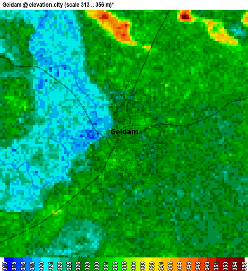
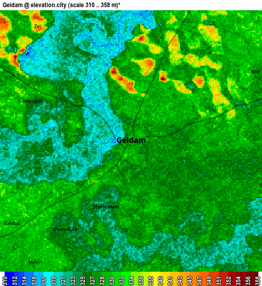
Below is the Elevation map of Geidam, which displays elevation range with different colors. Scale of the first map is from 313 to 356 m (1027 to 1168 ft) with average elevation of 326.9 meters (=1073 ft) [note 1]
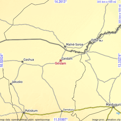
These maps also provides idea of topography and contour of this city, they are displayed at different zoom levels. More info about maps, scale and edge coordinates you can find below images.
| \ | Map #1 | Map #2 | Topo.Map |
| Scale [m] | 313..356 m | 310..358 m | × |
| Scale [ft] | 1027..1168 ft | 1017..1175 ft | × |
| Average | 326.9 m = 1073 ft | 327.1 m = 1073 ft | × |
| Width | 9.53 km = 5.9 mi | 19.05 km = 11.8 mi | 304.8 km = 189.4 mi |
| Height | 9.53 km = 5.9 mi | 19.05 km = 11.8 mi | 304.8 km = 189.4 mi |
| ↑Max Latitude | 12.937223° | 12.98005° | 14.2613° |
| Latitude at center | 12.89439° | 12.89439° | 12.89439° |
| ↓Min Latitude | 12.851549° | 12.808701° | 11.51997° |
| ← Min Longitude | 11.882545° | 11.838599° | 10.52024° |
| Longitude center | 11.92649° | 11.92649° | 11.92649° |
| →Max Longitude | 11.970435° | 12.014381° | 13.33274° |
Nearby cities:
Cities around Geidam sort by population:
• Gashua elevation 339 m
96.1 km,  268°
268°
• Damaturu 371 m
127.6 km,  178°
178°
• Magumeri 336 m
130.6 km,  131°
131°
• Dapchi 341 m
64.1 km,  226°
226°
• Damasak 313 m
67.3 km,  69°
69°
• Lajere 366 m
114.6 km,  207°
207°
• Gwio Kura 342 m
96.4 km,  255°
255°
• Bornu Yassu 332 m
98 km, 134°
• Jajimaji 342 m
121.3 km, 270°
• Gubio 305 m
102.6 km,  115°
115°
• Babban Gida 355 m
83.9 km,  191°
191°
• Kanamma 324 m
30.1 km,  40°
40°
Multilingual:
 En español:
Geidam elevación 329 m.
 En France:
Geidam élévation 329 m.


Sources and notes:
- [note 1] Map square and city borders are not equal. Map elevation data is calculated only from area inside that square.
- [src 1] Elevation data from geonames database provided with same terms of usage.
- [src 2] The elevation map of Geidam is generated using elevation data from NASA's 3 arcsec (90m) resolution SRTM data.
- [src 3] Base (background) map © OpenStreetMap contributors tiles are generated by Geofabrik and OpenTopoMap.
Copyright & License:
This Geidam Elevation Map is licensed under CC BY-SA. You may reuse any part from this page, if you give a proper credit by linking to this URL:
 More info on terms of use page.