Goniri elevation
Goniri (Yobe, Gujba), Nigeria elevation is 405 meters and Goniri elevation in feet is 1329 ft above sea level [src 1]. Goniri is a populated place (feature code) with elevation that is 108 meters (354 ft) bigger than average city elevation in Nigeria.
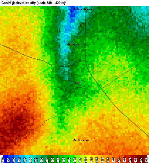
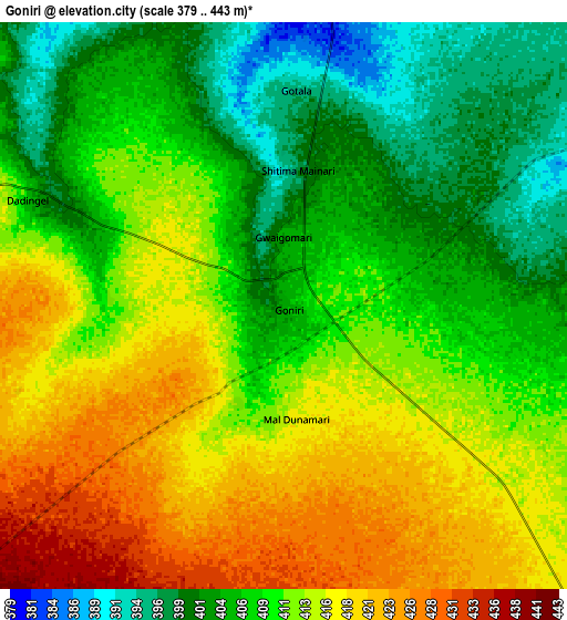
Below is the Elevation map of Goniri, which displays elevation range with different colors. Scale of the first map is from 389 to 429 m (1276 to 1407 ft) with average elevation of 410.7 meters (=1347 ft) [note 1]
These maps also provides idea of topography and contour of this city, they are displayed at different zoom levels. More info about maps, scale and edge coordinates you can find below images.
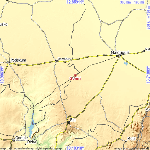
| \ | Map #1 | Map #2 | Topo.Map |
| Scale [m] | 389..429 m | 379..443 m | × |
| Scale [ft] | 1276..1407 ft | 1243..1453 ft | × |
| Average | 410.7 m = 1347 ft | 410.6 m = 1347 ft | × |
| Width | 9.58 km = 6 mi | 19.15 km = 11.9 mi | 306.4 km = 190.4 mi |
| Height | 9.58 km = 6 mi | 19.15 km = 11.9 mi | 306.5 km = 190.4 mi |
| ↑Max Latitude | 11.527572° | 11.570628° | 12.85911° |
| Latitude at center | 11.48451° | 11.48451° | 11.48451° |
| ↓Min Latitude | 11.441441° | 11.398366° | 10.10318° |
| ← Min Longitude | 12.268695° | 12.224749° | 10.90639° |
| Longitude center | 12.31264° | 12.31264° | 12.31264° |
| →Max Longitude | 12.356585° | 12.400531° | 13.71889° |
Nearby cities:
Cities around Goniri sort by population:
• Damaturu elevation 371 m
48.2 km,  307°
307°
• Damboa 401 m
60.7 km,  127°
127°
• Magumeri 336 m
89.6 km,  38°
38°
• Miringa 659 m
85.7 km,  192°
192°
• Gujba 420 m
41.3 km,  272°
272°
• Benisheikh 351 m
41 km,  28°
28°
• Yajiwa 377 m
45.7 km,  103°
103°
• Bornu Yassu 332 m
92.2 km,  17°
17°
• Dankalwa 397 m
32.1 km,  334°
334°
• Bara 289 m
91.9 km,  228°
228°
• Chibok 464 m
89.8 km,  139°
139°
• Buni Yadi 443 m
40.6 km, 234°
Multilingual:
 En español:
Goniri elevación 405 m.
 En France:
Goniri élévation 405 m.


Sources and notes:
- [note 1] Map square and city borders are not equal. Map elevation data is calculated only from area inside that square.
- [src 1] Elevation data from geonames database provided with same terms of usage.
- [src 2] The elevation map of Goniri is generated using elevation data from NASA's 3 arcsec (90m) resolution SRTM data.
- [src 3] Base (background) map © OpenStreetMap contributors tiles are generated by Geofabrik and OpenTopoMap.
Copyright & License:
This Goniri Elevation Map is licensed under CC BY-SA. You may reuse any part from this page, if you give a proper credit by linking to this URL:
 More info on terms of use page.