Icheu elevation
Icheu (Kogi, Bassa), Nigeria elevation is 47 meters and Icheu elevation in feet is 154 ft above sea level [src 1]. Icheu is a populated place (feature code) with elevation that is 250 meters (820 ft) smaller than average city elevation in Nigeria.
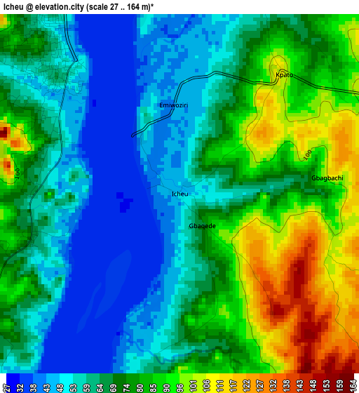
Below is the Elevation map of Icheu, which displays elevation range with different colors. Scale of the first map is from 27 to 164 m (89 to 538 ft) with average elevation of 70.4 meters (=231 ft) [note 1]
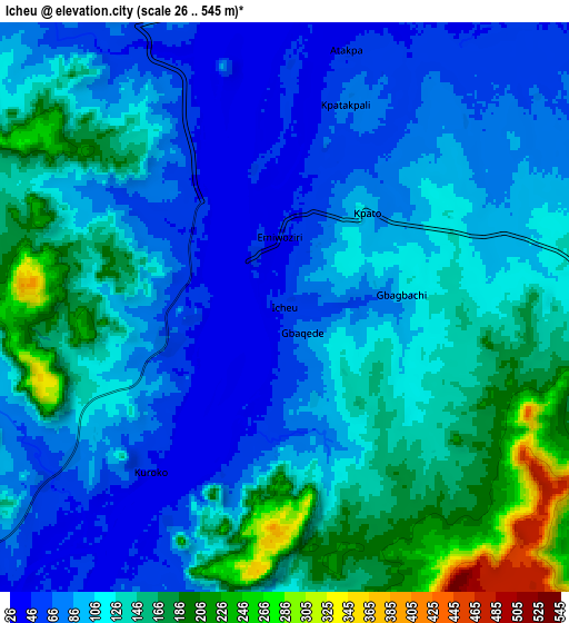
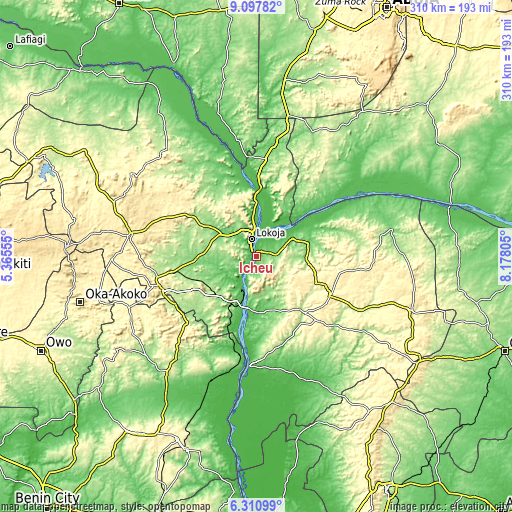
These maps also provides idea of topography and contour of this city, they are displayed at different zoom levels. More info about maps, scale and edge coordinates you can find below images.
| \ | Map #1 | Map #2 | Topo.Map |
| Scale [m] | 27..164 m | 26..545 m | × |
| Scale [ft] | 89..538 ft | 85..1788 ft | × |
| Average | 70.4 m = 231 ft | 114.4 m = 375 ft | × |
| Width | 9.68 km = 6 mi | 19.37 km = 12 mi | 309.9 km = 192.6 mi |
| Height | 9.68 km = 6 mi | 19.37 km = 12 mi | 309.9 km = 192.6 mi |
| ↑Max Latitude | 7.750246° | 7.793788° | 9.09782° |
| Latitude at center | 7.7067° | 7.7067° | 7.7067° |
| ↓Min Latitude | 7.663149° | 7.619594° | 6.31099° |
| ← Min Longitude | 6.727855° | 6.683909° | 5.36555° |
| Longitude center | 6.7718° | 6.7718° | 6.7718° |
| →Max Longitude | 6.815745° | 6.859691° | 8.17805° |
Nearby cities:
Cities around Icheu sort by population:
• Okene elevation 384 m
61.5 km,  253°
253°
• Ogaminana 247 m
62.3 km,  258°
258°
• Lokoja 53 m
10.6 km,  341°
341°
• Ajaokuta 52 m
20.6 km,  218°
218°
• Dekina 141 m
30 km,  93°
93°
• Koton-Karfe 51 m
42.8 km,  3°
3°
• Abocho 412 m
28.2 km,  123°
123°
• Obangede 238 m
63.8 km, 261°
• Ajaka 210 m
59.5 km,  174°
174°
• Ugwolawo 114 m
54.9 km,  162°
162°
• Adogo 222 m
38.9 km,  235°
235°
• Oguma 52 m
38.3 km,  56°
56°
Multilingual:
 En español:
Icheu elevación 47 m.
 En France:
Icheu élévation 47 m.


Sources and notes:
- [note 1] Map square and city borders are not equal. Map elevation data is calculated only from area inside that square.
- [src 1] Elevation data from geonames database provided with same terms of usage.
- [src 2] The elevation map of Icheu is generated using elevation data from NASA's 3 arcsec (90m) resolution SRTM data.
- [src 3] Base (background) map © OpenStreetMap contributors tiles are generated by Geofabrik and OpenTopoMap.
Copyright & License:
This Icheu Elevation Map is licensed under CC BY-SA. You may reuse any part from this page, if you give a proper credit by linking to this URL:
 More info on terms of use page.