Ikang elevation
Ikang (Cross River, Akpabuyo), Nigeria elevation is 9 meters and Ikang elevation in feet is 30 ft above sea level [src 1]. Ikang is a populated place (feature code) with elevation that is 288 meters (945 ft) smaller than average city elevation in Nigeria.
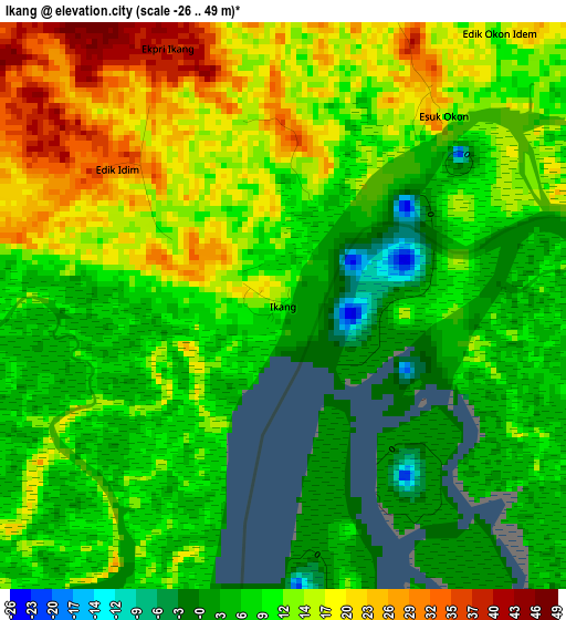
Below is the Elevation map of Ikang, which displays elevation range with different colors. Scale of the first map is from -26 to 49 m (-85 to 161 ft) with average elevation of 11.7 meters (=38 ft) [note 1]
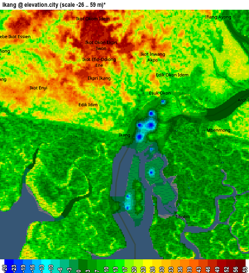
These maps also provides idea of topography and contour of this city, they are displayed at different zoom levels. More info about maps, scale and edge coordinates you can find below images.
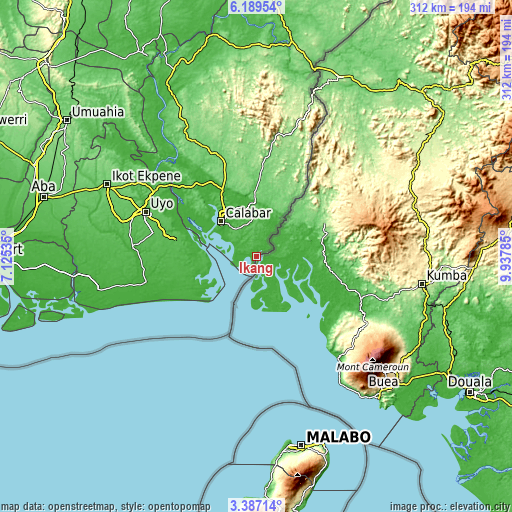
| \ | Map #1 | Map #2 | Topo.Map |
| Scale [m] | -26..49 m | -26..59 m | × |
| Scale [ft] | -85..161 ft | -85..194 ft | × |
| Average | 11.7 m = 38 ft | 15.9 m = 52 ft | × |
| Width | 9.74 km = 6.1 mi | 19.48 km = 12.1 mi | 311.6 km = 193.6 mi |
| Height | 9.74 km = 6.1 mi | 19.48 km = 12.1 mi | 311.6 km = 193.6 mi |
| ↑Max Latitude | 4.83357° | 4.877358° | 6.18954° |
| Latitude at center | 4.78978° | 4.78978° | 4.78978° |
| ↓Min Latitude | 4.745987° | 4.702191° | 3.38714° |
| ← Min Longitude | 8.487655° | 8.443709° | 7.12535° |
| Longitude center | 8.5316° | 8.5316° | 8.5316° |
| →Max Longitude | 8.575545° | 8.619491° | 9.93785° |
Nearby cities:
Cities around Ikang sort by population:
• Calabar elevation 37 m
29.5 km,  309°
309°
• Esuk Oron 38 m
30.9 km,  272°
272°
• Akankpa 80 m
53.2 km, 314°
• Odot 48 m
54.8 km, 274°
• Uquo 39 m
54.4 km,  254°
254°
• Okopedi 49 m
45.5 km,  278°
278°
• Odukpani 27 m
43.8 km,  330°
330°
• Urue Offong 39 m
40.5 km,  264°
264°
• Enwang 28 m
34.3 km,  244°
244°
• Eyofin 33 m
33.6 km, 262°
• Oron 20 m
33 km, 276°
• Ikot Nakanda 53 m
11.8 km, 333°
Multilingual:
 En español:
Ikang elevación 9 m.
 En France:
Ikang élévation 9 m.


Sources and notes:
- [note 1] Map square and city borders are not equal. Map elevation data is calculated only from area inside that square.
- [src 1] Elevation data from geonames database provided with same terms of usage.
- [src 2] The elevation map of Ikang is generated using elevation data from NASA's 3 arcsec (90m) resolution SRTM data.
- [src 3] Base (background) map © OpenStreetMap contributors tiles are generated by Geofabrik and OpenTopoMap.
Copyright & License:
This Ikang Elevation Map is licensed under CC BY-SA. You may reuse any part from this page, if you give a proper credit by linking to this URL:
 More info on terms of use page.