Ikem elevation
Ikem (Enugu, Isi-Uzo), Nigeria elevation is 146 meters and Ikem elevation in feet is 479 ft above sea level [src 1]. Ikem is a seat of a second-order administrative division (feature code) with elevation that is 151 meters (495 ft) smaller than average city elevation in Nigeria.
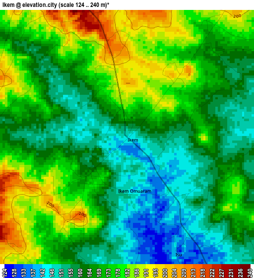
Below is the Elevation map of Ikem, which displays elevation range with different colors. Scale of the first map is from 124 to 240 m (407 to 787 ft) with average elevation of 168.6 meters (=553 ft) [note 1]
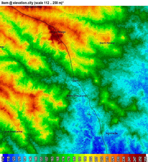
These maps also provides idea of topography and contour of this city, they are displayed at different zoom levels. More info about maps, scale and edge coordinates you can find below images.
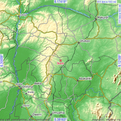
| \ | Map #1 | Map #2 | Topo.Map |
| Scale [m] | 124..240 m | 112..258 m | × |
| Scale [ft] | 407..787 ft | 367..846 ft | × |
| Average | 168.6 m = 553 ft | 172.4 m = 566 ft | × |
| Width | 9.7 km = 6 mi | 19.41 km = 12.1 mi | 310.5 km = 192.9 mi |
| Height | 9.7 km = 6 mi | 19.41 km = 12.1 mi | 310.5 km = 192.9 mi |
| ↑Max Latitude | 6.823566° | 6.867198° | 8.17419° |
| Latitude at center | 6.77993° | 6.77993° | 6.77993° |
| ↓Min Latitude | 6.73629° | 6.692646° | 5.38163° |
| ← Min Longitude | 7.670895° | 7.626949° | 6.30859° |
| Longitude center | 7.71484° | 7.71484° | 7.71484° |
| →Max Longitude | 7.758785° | 7.802731° | 9.12109° |
Nearby cities:
Cities around Ikem sort by population:
• Nsukka elevation 423 m
36.3 km,  283°
283°
• Eha Amufu 109 m
14.3 km,  159°
159°
• Otukpa 417 m
36.3 km,  350°
350°
• Enugu-Ezike 376 m
36.5 km,  308°
308°
• Opi 496 m
31.1 km,  270°
270°
• Obolo-Eke (1) 251 m
14.6 km,  321°
321°
• Ogbede 361 m
39.4 km,  252°
252°
• Ibagwa-Aka 337 m
38.1 km,  293°
293°
• Nkwo Nike 173 m
37.7 km,  216°
216°
• Okpoga 193 m
30.8 km,  20°
20°
• Igumale 81 m
28 km,  85°
85°
• Obollo-Afor 484 m
26.4 km,  304°
304°
Multilingual:
 En español:
Ikem elevación 146 m.
 En France:
Ikem élévation 146 m.


Sources and notes:
- [note 1] Map square and city borders are not equal. Map elevation data is calculated only from area inside that square.
- [src 1] Elevation data from geonames database provided with same terms of usage.
- [src 2] The elevation map of Ikem is generated using elevation data from NASA's 3 arcsec (90m) resolution SRTM data.
- [src 3] Base (background) map © OpenStreetMap contributors tiles are generated by Geofabrik and OpenTopoMap.
Copyright & License:
This Ikem Elevation Map is licensed under CC BY-SA. You may reuse any part from this page, if you give a proper credit by linking to this URL:
 More info on terms of use page.