Isieke elevation
Isieke (Ebonyi, Ohaukwu), Nigeria elevation is 68 meters and Isieke elevation in feet is 223 ft above sea level [src 1]. Isieke is a populated place (feature code) with elevation that is 229 meters (751 ft) smaller than average city elevation in Nigeria.
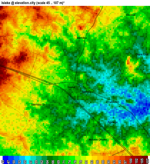
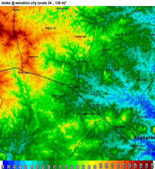
Below is the Elevation map of Isieke, which displays elevation range with different colors. Scale of the first map is from 45 to 107 m (148 to 351 ft) with average elevation of 74.6 meters (=245 ft) [note 1]
These maps also provides idea of topography and contour of this city, they are displayed at different zoom levels. More info about maps, scale and edge coordinates you can find below images.
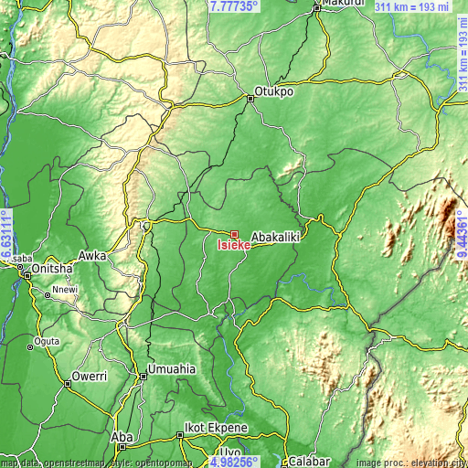
| \ | Map #1 | Map #2 | Topo.Map |
| Scale [m] | 45..107 m | 34..138 m | × |
| Scale [ft] | 148..351 ft | 112..453 ft | × |
| Average | 74.6 m = 245 ft | 77.4 m = 254 ft | × |
| Width | 9.71 km = 6 mi | 19.42 km = 12.1 mi | 310.8 km = 193.1 mi |
| Height | 9.71 km = 6 mi | 19.42 km = 12.1 mi | 310.8 km = 193.1 mi |
| ↑Max Latitude | 6.425531° | 6.469199° | 7.77735° |
| Latitude at center | 6.38186° | 6.38186° | 6.38186° |
| ↓Min Latitude | 6.338185° | 6.294507° | 4.98256° |
| ← Min Longitude | 7.993415° | 7.949469° | 6.63111° |
| Longitude center | 8.03736° | 8.03736° | 8.03736° |
| →Max Longitude | 8.081305° | 8.125251° | 9.44361° |
Nearby cities:
Cities around Isieke sort by population:
• Abakaliki elevation 65 m
10.6 km,  126°
126°
• Effium 115 m
27.8 km,  4°
4°
• Eha Amufu 109 m
43.5 km,  315°
315°
• Ezza-Ohu 80 m
8.4 km,  38°
38°
• Amagunze 92 m
42.9 km,  262°
262°
• Isu 100 m
36.7 km,  225°
225°
• Onuebonyi Echara 56 m
34.3 km,  158°
158°
• Onueke 91 m
25.2 km,  180°
180°
• Ezillo 71 m
24.8 km,  282°
282°
• Iboko 78 m
21.8 km,  82°
82°
• Ugbodo 89 m
17.7 km, 35°
• Ezzamgbo 97 m
8.6 km, 282°
Multilingual:
 En español:
Isieke elevación 68 m.
 En France:
Isieke élévation 68 m.


Sources and notes:
- [note 1] Map square and city borders are not equal. Map elevation data is calculated only from area inside that square.
- [src 1] Elevation data from geonames database provided with same terms of usage.
- [src 2] The elevation map of Isieke is generated using elevation data from NASA's 3 arcsec (90m) resolution SRTM data.
- [src 3] Base (background) map © OpenStreetMap contributors tiles are generated by Geofabrik and OpenTopoMap.
Copyright & License:
This Isieke Elevation Map is licensed under CC BY-SA. You may reuse any part from this page, if you give a proper credit by linking to this URL:
 More info on terms of use page.