Jos elevation
Jos (Plateau, Jos North), Nigeria elevation is 1186 meters and Jos elevation in feet is 3891 ft above sea level [src 1]. Jos is a seat of a first-order administrative division (feature code) with elevation that is 889 meters (2917 ft) bigger than average city elevation in Nigeria.
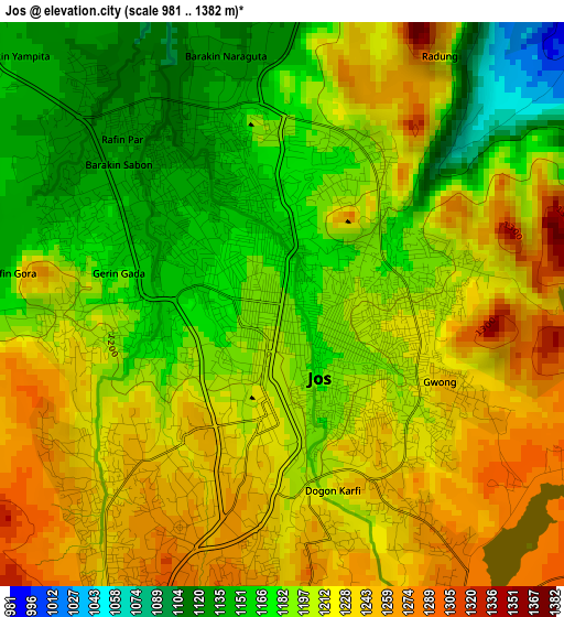
Below is the Elevation map of Jos, which displays elevation range with different colors. Scale of the first map is from 981 to 1382 m (3219 to 4534 ft) with average elevation of 1203.9 meters (=3950 ft) [note 1]
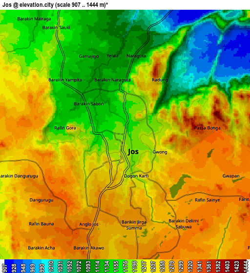
These maps also provides idea of topography and contour of this city, they are displayed at different zoom levels. More info about maps, scale and edge coordinates you can find below images.
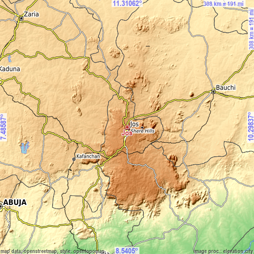
| \ | Map #1 | Map #2 | Topo.Map |
| Scale [m] | 981..1382 m | 907..1444 m | × |
| Scale [ft] | 3219..4534 ft | 2976..4738 ft | × |
| Average | 1203.9 m = 3950 ft | 1207.3 m = 3961 ft | × |
| Width | 9.63 km = 6 mi | 19.25 km = 12 mi | 308 km = 191.4 mi |
| Height | 9.63 km = 6 mi | 19.25 km = 12 mi | 308 km = 191.4 mi |
| ↑Max Latitude | 9.971774° | 10.015053° | 11.31062° |
| Latitude at center | 9.92849° | 9.92849° | 9.92849° |
| ↓Min Latitude | 9.8852° | 9.841904° | 8.5405° |
| ← Min Longitude | 8.848175° | 8.804229° | 7.48587° |
| Longitude center | 8.89212° | 8.89212° | 8.89212° |
| →Max Longitude | 8.936065° | 8.980011° | 10.29837° |
Nearby cities:
Cities around Jos sort by population:
• Lere elevation 753 m
61.7 km,  325°
325°
• Bukuru 1277 m
15.3 km,  191°
191°
• Lere 873 m
54.8 km,  116°
116°
• Vom 1275 m
24.8 km,  206°
206°
• Saminaka 765 m
58.3 km,  337°
337°
• Kaura 968 m
55.7 km,  238°
238°
• Mangu 1127 m
50.6 km,  153°
153°
• Barkin Ladi 1301 m
43.4 km,  179°
179°
• Riyom 1205 m
35.7 km,  204°
204°
• Angware 938 m
24.7 km,  73°
73°
• Toro 978 m
24.2 km,  53°
53°
• Bassa 1168 m
16.7 km,  275°
275°
Multilingual:
 En español:
Jos elevación 1186 m.
 En France:
Jos élévation 1186 m.


Sources and notes:
- [note 1] Map square and city borders are not equal. Map elevation data is calculated only from area inside that square.
- [src 1] Elevation data from geonames database provided with same terms of usage.
- [src 2] The elevation map of Jos is generated using elevation data from NASA's 3 arcsec (90m) resolution SRTM data.
- [src 3] Base (background) map © OpenStreetMap contributors tiles are generated by Geofabrik and OpenTopoMap.
Copyright & License:
This Jos Elevation Map is licensed under CC BY-SA. You may reuse any part from this page, if you give a proper credit by linking to this URL:
 More info on terms of use page.