Kachia elevation
Kachia (Kaduna), Nigeria elevation is 718 meters and Kachia elevation in feet is 2356 ft above sea level [src 1]. Kachia is a seat of a second-order administrative division (feature code) with elevation that is 421 meters (1381 ft) bigger than average city elevation in Nigeria.
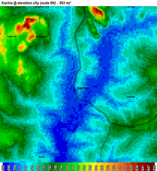
Below is the Elevation map of Kachia, which displays elevation range with different colors. Scale of the first map is from 692 to 853 m (2270 to 2799 ft) with average elevation of 729 meters (=2392 ft) [note 1]
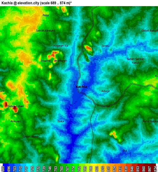
These maps also provides idea of topography and contour of this city, they are displayed at different zoom levels. More info about maps, scale and edge coordinates you can find below images.
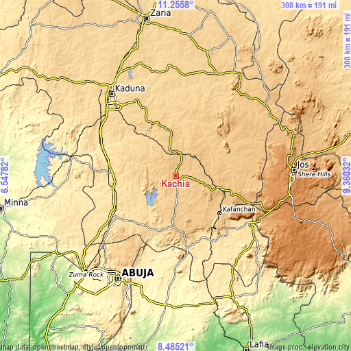
| \ | Map #1 | Map #2 | Topo.Map |
| Scale [m] | 692..853 m | 689..874 m | × |
| Scale [ft] | 2270..2799 ft | 2260..2867 ft | × |
| Average | 729 m = 2392 ft | 745.8 m = 2447 ft | × |
| Width | 9.63 km = 6 mi | 19.26 km = 12 mi | 308.1 km = 191.4 mi |
| Height | 9.63 km = 6 mi | 19.26 km = 12 mi | 308.1 km = 191.4 mi |
| ↑Max Latitude | 9.916712° | 9.959997° | 11.2558° |
| Latitude at center | 9.87342° | 9.87342° | 9.87342° |
| ↓Min Latitude | 9.830123° | 9.78682° | 8.48521° |
| ← Min Longitude | 7.910125° | 7.866179° | 6.54782° |
| Longitude center | 7.95407° | 7.95407° | 7.95407° |
| →Max Longitude | 7.998015° | 8.041961° | 9.36032° |
Nearby cities:
Cities around Kachia sort by population:
• Lere elevation 753 m
88.5 km,  49°
49°
• Kafanchan 733 m
49.3 km,  131°
131°
• Kagoro 816 m
56.2 km,  121°
121°
• Kajuru 686 m
58 km,  329°
329°
• Kujama 663 m
73.6 km, 331°
• Makera 604 m
89.2 km,  318°
318°
• Bassa 1168 m
86.5 km,  84°
84°
• Kauru 649 m
81 km,  15°
15°
• Kaura 968 m
59.8 km,  112°
112°
• Kagarko 672 m
51 km,  213°
213°
• Kwoi 773 m
46.6 km,  172°
172°
• Zonkwa 859 m
38.2 km, 105°
Multilingual:
 En español:
Kachia elevación 718 m.
 En France:
Kachia élévation 718 m.


Sources and notes:
- [note 1] Map square and city borders are not equal. Map elevation data is calculated only from area inside that square.
- [src 1] Elevation data from geonames database provided with same terms of usage.
- [src 2] The elevation map of Kachia is generated using elevation data from NASA's 3 arcsec (90m) resolution SRTM data.
- [src 3] Base (background) map © OpenStreetMap contributors tiles are generated by Geofabrik and OpenTopoMap.
Copyright & License:
This Kachia Elevation Map is licensed under CC BY-SA. You may reuse any part from this page, if you give a proper credit by linking to this URL:
 More info on terms of use page.