Kano elevation
Kano, Nigeria elevation is 484 meters and Kano elevation in feet is 1588 ft above sea level [src 1]. Kano is a seat of a first-order administrative division (feature code) with elevation that is 187 meters (614 ft) bigger than average city elevation in Nigeria.
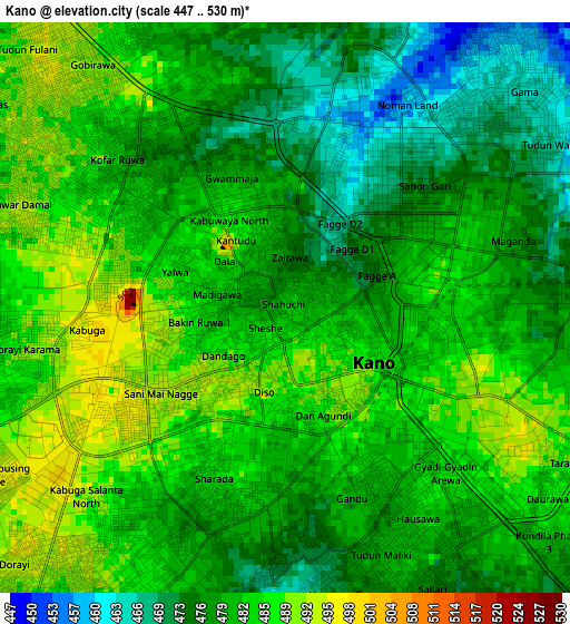
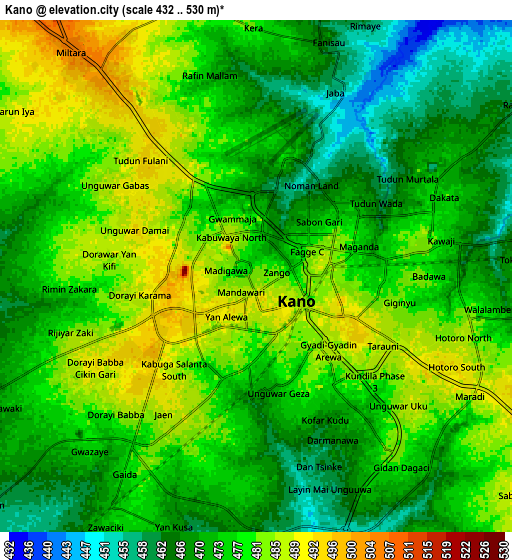
Below is the Elevation map of Kano, which displays elevation range with different colors. Scale of the first map is from 447 to 530 m (1467 to 1739 ft) with average elevation of 481 meters (=1578 ft) [note 1]
These maps also provides idea of topography and contour of this city, they are displayed at different zoom levels. More info about maps, scale and edge coordinates you can find below images.
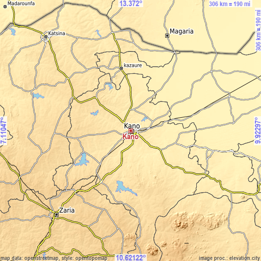
| \ | Map #1 | Map #2 | Topo.Map |
| Scale [m] | 447..530 m | 432..530 m | × |
| Scale [ft] | 1467..1739 ft | 1417..1739 ft | × |
| Average | 481 m = 1578 ft | 475.2 m = 1559 ft | × |
| Width | 9.56 km = 5.9 mi | 19.12 km = 11.9 mi | 305.9 km = 190.1 mi |
| Height | 9.56 km = 5.9 mi | 19.12 km = 11.9 mi | 305.9 km = 190.1 mi |
| ↑Max Latitude | 12.043102° | 12.086076° | 13.372° |
| Latitude at center | 12.00012° | 12.00012° | 12.00012° |
| ↓Min Latitude | 11.957132° | 11.914136° | 10.62122° |
| ← Min Longitude | 8.472775° | 8.428829° | 7.11047° |
| Longitude center | 8.51672° | 8.51672° | 8.51672° |
| →Max Longitude | 8.560665° | 8.604611° | 9.92297° |
Nearby cities:
Cities around Kano sort by population:
• Kura elevation 477 m
27.2 km,  201°
201°
• Madobi 492 m
35.1 km,  225°
225°
• Bunkure 474 m
33.6 km,  175°
175°
• Rimin Gado 521 m
29.5 km,  262°
262°
• Gezawa 443 m
27.8 km,  66°
66°
• Tofa 501 m
27.3 km,  283°
283°
• Warawa 451 m
25 km,  126°
126°
• Minjibir 451 m
25 km,  37°
37°
• Dawakin Tofa 484 m
23.4 km,  299°
299°
• Dawakin Kudu 451 m
20.1 km,  154°
154°
• Kumbotso 455 m
12.3 km,  186°
186°
• Ungogo 487 m
10.4 km,  347°
347°
Multilingual:
 En español:
Kano elevación 484 m.
 En France:
Kano élévation 484 m.


Sources and notes:
- [note 1] Map square and city borders are not equal. Map elevation data is calculated only from area inside that square.
- [src 1] Elevation data from geonames database provided with same terms of usage.
- [src 2] The elevation map of Kano is generated using elevation data from NASA's 3 arcsec (90m) resolution SRTM data.
- [src 3] Base (background) map © OpenStreetMap contributors tiles are generated by Geofabrik and OpenTopoMap.
Copyright & License:
This Kano Elevation Map is licensed under CC BY-SA. You may reuse any part from this page, if you give a proper credit by linking to this URL:
 More info on terms of use page.