Imeko elevation
Imeko (Ogun, Imeko Afon), Nigeria elevation is 204 meters and Imeko elevation in feet is 669 ft above sea level [src 1]. Imeko is a seat of a second-order administrative division (feature code) with elevation that is 93 meters (305 ft) smaller than average city elevation in Nigeria.
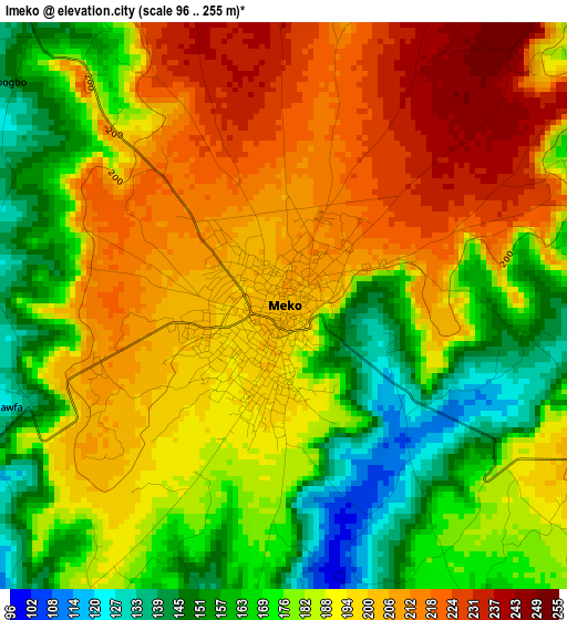
Below is the Elevation map of Imeko, which displays elevation range with different colors. Scale of the first map is from 96 to 255 m (315 to 837 ft) with average elevation of 187.3 meters (=615 ft) [note 1]
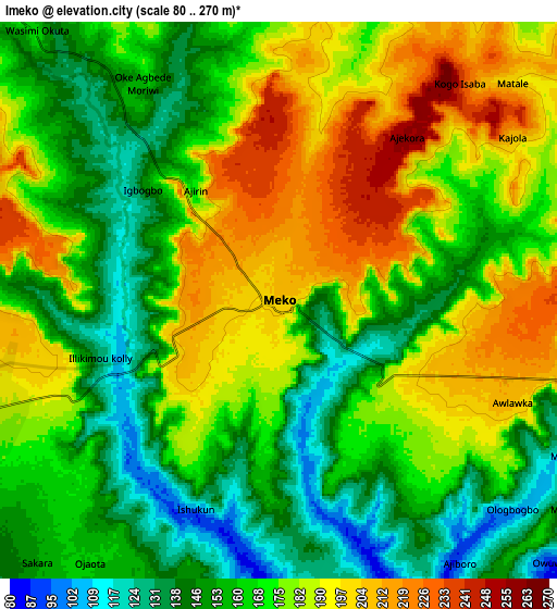
These maps also provides idea of topography and contour of this city, they are displayed at different zoom levels. More info about maps, scale and edge coordinates you can find below images.
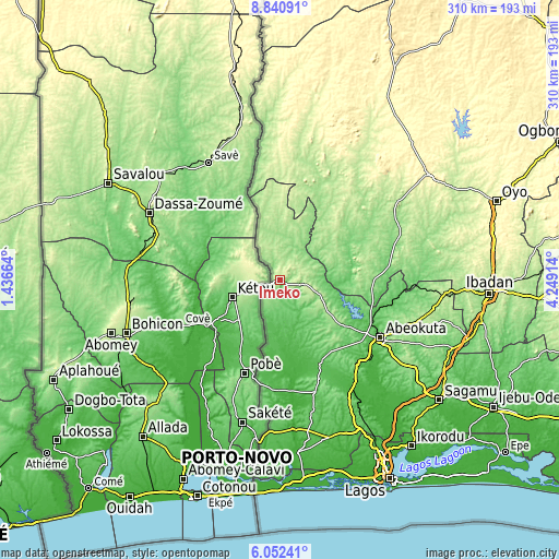
| \ | Map #1 | Map #2 | Topo.Map |
| Scale [m] | 96..255 m | 80..270 m | × |
| Scale [ft] | 315..837 ft | 262..886 ft | × |
| Average | 187.3 m = 615 ft | 171.2 m = 562 ft | × |
| Width | 9.69 km = 6 mi | 19.38 km = 12 mi | 310.1 km = 192.7 mi |
| Height | 9.69 km = 6 mi | 19.38 km = 12 mi | 310.1 km = 192.7 mi |
| ↑Max Latitude | 7.492452° | 7.53602° | 8.84091° |
| Latitude at center | 7.44888° | 7.44888° | 7.44888° |
| ↓Min Latitude | 7.405303° | 7.361722° | 6.05241° |
| ← Min Longitude | 2.798945° | 2.754999° | 1.43664° |
| Longitude center | 2.84289° | 2.84289° | 2.84289° |
| →Max Longitude | 2.886835° | 2.930781° | 4.24914° |
Nearby cities:
Cities around Imeko sort by population:
• Abeokuta elevation 64 m
64.3 km,  120°
120°
• Igbo-Ora 170 m
49.1 km,  91°
91°
• Ifo 65 m
80.5 km,  151°
151°
• Orita Eruwa 187 m
66.1 km,  80°
80°
• Ilaro 73 m
65.1 km,  163°
163°
• Okeho 417 m
85.6 km,  40°
40°
• Odeda 161 m
79.3 km,  107°
107°
• Itori 24 m
71.1 km,  144°
144°
• Iwere-Ile 206 m
66.9 km,  23°
23°
• Eruwa 182 m
64.1 km, 81°
• Ayete 143 m
43.1 km, 75°
• Ayetoro 105 m
30.6 km, 138°
Multilingual:
 En español:
Imeko elevación 204 m.
 En France:
Imeko élévation 204 m.


Sources and notes:
- [note 1] Map square and city borders are not equal. Map elevation data is calculated only from area inside that square.
- [src 1] Elevation data from geonames database provided with same terms of usage.
- [src 2] The elevation map of Imeko is generated using elevation data from NASA's 3 arcsec (90m) resolution SRTM data.
- [src 3] Base (background) map © OpenStreetMap contributors tiles are generated by Geofabrik and OpenTopoMap.
Copyright & License:
This Imeko Elevation Map is licensed under CC BY-SA. You may reuse any part from this page, if you give a proper credit by linking to this URL:
 More info on terms of use page.