Ode elevation
Ode (Ondo), Nigeria elevation is 529 meters and Ode elevation in feet is 1736 ft above sea level [src 1]. Ode is a populated place (feature code) with elevation that is 232 meters (761 ft) bigger than average city elevation in Nigeria.
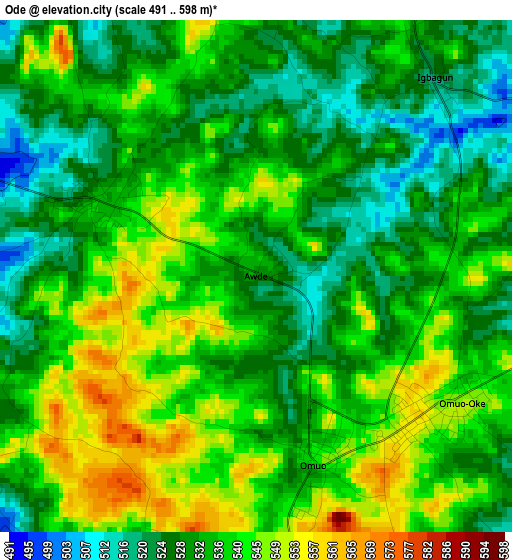
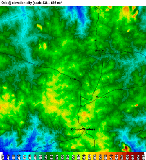
Below is the Elevation map of Ode, which displays elevation range with different colors. Scale of the first map is from 491 to 598 m (1611 to 1962 ft) with average elevation of 535.1 meters (=1756 ft) [note 1]
These maps also provides idea of topography and contour of this city, they are displayed at different zoom levels. More info about maps, scale and edge coordinates you can find below images.
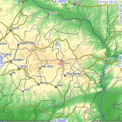
| \ | Map #1 | Map #2 | Topo.Map |
| Scale [m] | 491..598 m | 436..666 m | × |
| Scale [ft] | 1611..1962 ft | 1430..2185 ft | × |
| Average | 535.1 m = 1756 ft | 518.9 m = 1702 ft | × |
| Width | 9.68 km = 6 mi | 19.36 km = 12 mi | 309.8 km = 192.5 mi |
| Height | 9.68 km = 6 mi | 19.36 km = 12 mi | 309.8 km = 192.5 mi |
| ↑Max Latitude | 7.833438° | 7.87697° | 9.18072° |
| Latitude at center | 7.7899° | 7.7899° | 7.7899° |
| ↓Min Latitude | 7.746358° | 7.702811° | 6.39445° |
| ← Min Longitude | 5.667755° | 5.623809° | 4.30545° |
| Longitude center | 5.7117° | 5.7117° | 5.7117° |
| →Max Longitude | 5.755645° | 5.799591° | 7.11795° |
Nearby cities:
Cities around Ode sort by population:
• Ise-Ekiti elevation 379 m
48.1 km,  221°
221°
• Kabba 436 m
40.2 km,  84°
84°
• Omuo-Ekiti 546 m
3.7 km,  161°
161°
• Isua 357 m
43.3 km,  149°
149°
• Oye-Ekiti 536 m
41.8 km,  271°
271°
• Mopa 306 m
40.2 km,  29°
29°
• Oka 537 m
38 km, 164°
• Ikare 423 m
29.7 km,  171°
171°
• Iyara 463 m
29.1 km, 78°
• Ode-Ekiti 416 m
23.8 km,  228°
228°
• Ikole-Ekiti 570 m
22.4 km, 270°
• Oke-Agbe 505 m
17.1 km, 162°
Multilingual:
 En español:
Ode elevación 529 m.
 En France:
Ode élévation 529 m.


Sources and notes:
- [note 1] Map square and city borders are not equal. Map elevation data is calculated only from area inside that square.
- [src 1] Elevation data from geonames database provided with same terms of usage.
- [src 2] The elevation map of Ode is generated using elevation data from NASA's 3 arcsec (90m) resolution SRTM data.
- [src 3] Base (background) map © OpenStreetMap contributors tiles are generated by Geofabrik and OpenTopoMap.
Copyright & License:
This Ode Elevation Map is licensed under CC BY-SA. You may reuse any part from this page, if you give a proper credit by linking to this URL:
 More info on terms of use page.