Wamba elevation
Wamba (Nassarawa), Nigeria elevation is 388 meters and Wamba elevation in feet is 1273 ft above sea level [src 1]. Wamba is a seat of a second-order administrative division (feature code) with elevation that is 91 meters (299 ft) bigger than average city elevation in Nigeria.
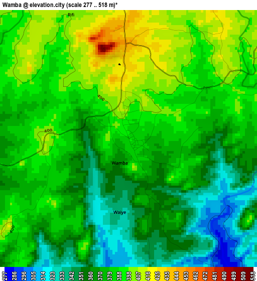
Below is the Elevation map of Wamba, which displays elevation range with different colors. Scale of the first map is from 277 to 518 m (909 to 1699 ft) with average elevation of 376.7 meters (=1236 ft) [note 1]
These maps also provides idea of topography and contour of this city, they are displayed at different zoom levels. More info about maps, scale and edge coordinates you can find below images.
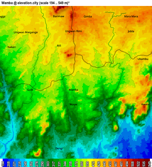
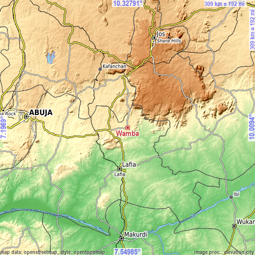
| \ | Map #1 | Map #2 | Topo.Map |
| Scale [m] | 277..518 m | 194..549 m | × |
| Scale [ft] | 909..1699 ft | 636..1801 ft | × |
| Average | 376.7 m = 1236 ft | 363 m = 1191 ft | × |
| Width | 9.65 km = 6 mi | 19.31 km = 12 mi | 308.9 km = 191.9 mi |
| Height | 9.65 km = 6 mi | 19.31 km = 12 mi | 308.9 km = 191.9 mi |
| ↑Max Latitude | 8.984939° | 9.028342° | 10.32791° |
| Latitude at center | 8.94153° | 8.94153° | 8.94153° |
| ↓Min Latitude | 8.898116° | 8.854697° | 7.54985° |
| ← Min Longitude | 8.559205° | 8.515259° | 7.1969° |
| Longitude center | 8.60315° | 8.60315° | 8.60315° |
| →Max Longitude | 8.647095° | 8.691041° | 10.0094° |
Nearby cities:
Cities around Wamba sort by population:
• Lafia elevation 179 m
50.7 km,  190°
190°
• Kagoro 816 m
77.7 km,  342°
342°
• Akwanga 454 m
21.9 km,  261°
261°
• Doma 157 m
66.8 km,  204°
204°
• Bokkos 1336 m
58.6 km,  47°
47°
• Kwolla 269 m
75.7 km,  93°
93°
• Barkin Ladi 1301 m
73.6 km,  25°
25°
• Baap 299 m
70.1 km, 89°
• Obi 180 m
66.3 km,  163°
163°
• Garaku 378 m
53 km, 258°
• Gwantu 549 m
35.7 km,  333°
333°
• Nasarawa Egon 272 m
26.4 km, 195°
Multilingual:
 En español:
Wamba elevación 388 m.
 En France:
Wamba élévation 388 m.


Sources and notes:
- [note 1] Map square and city borders are not equal. Map elevation data is calculated only from area inside that square.
- [src 1] Elevation data from geonames database provided with same terms of usage.
- [src 2] The elevation map of Wamba is generated using elevation data from NASA's 3 arcsec (90m) resolution SRTM data.
- [src 3] Base (background) map © OpenStreetMap contributors tiles are generated by Geofabrik and OpenTopoMap.
Copyright & License:
This Wamba Elevation Map is licensed under CC BY-SA. You may reuse any part from this page, if you give a proper credit by linking to this URL:
 More info on terms of use page.