Matamey elevation
Matamey (Zinder), Niger elevation is 445 meters and Matamey elevation in feet is 1460 ft above sea level [src 1]. Matamey is a populated place (feature code) with elevation that is 102 meters (335 ft) bigger than average city elevation in Niger.
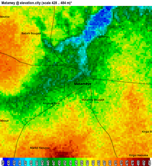
Below is the Elevation map of Matamey, which displays elevation range with different colors. Scale of the first map is from 428 to 484 m (1404 to 1588 ft) with average elevation of 457.5 meters (=1501 ft) [note 1]
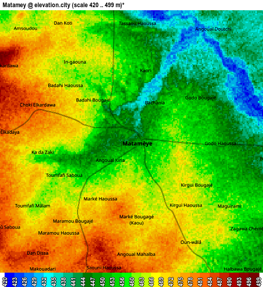
These maps also provides idea of topography and contour of this city, they are displayed at different zoom levels. More info about maps, scale and edge coordinates you can find below images.
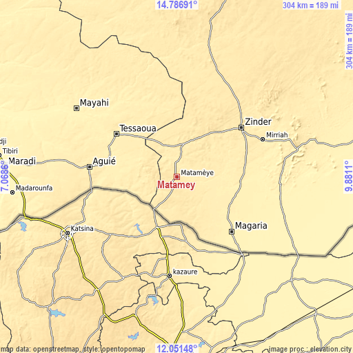
| \ | Map #1 | Map #2 | Topo.Map |
| Scale [m] | 428..484 m | 420..499 m | × |
| Scale [ft] | 1404..1588 ft | 1378..1637 ft | × |
| Average | 457.5 m = 1501 ft | 460.4 m = 1510 ft | × |
| Width | 9.51 km = 5.9 mi | 19.01 km = 11.8 mi | 304.2 km = 189 mi |
| Height | 9.51 km = 5.9 mi | 19.01 km = 11.8 mi | 304.2 km = 189 mi |
| ↑Max Latitude | 13.465831° | 13.508564° | 14.78691° |
| Latitude at center | 13.42309° | 13.42309° | 13.42309° |
| ↓Min Latitude | 13.380341° | 13.337585° | 12.05148° |
| ← Min Longitude | 8.430905° | 8.386959° | 7.0686° |
| Longitude center | 8.47485° | 8.47485° | 8.47485° |
| →Max Longitude | 8.518795° | 8.562741° | 9.8811° |
Nearby cities:
Cities around Matamey sort by population:
• Zinder elevation 460 m
70 km,  52°
52°
• Maradi 360 m
148.7 km,  273°
273°
• Tessaoua 400 m
64.5 km,  305°
305°
• Mayahi 389 m
105.1 km,  304°
304°
• Mirriah 407 m
79.5 km,  66°
66°
• Tibiri 347 m
155 km,  275°
275°
• Magaria 396 m
66.7 km,  135°
135°
• Tanout 525 m
177.8 km,  14°
14°
• Aguié 424 m
75.8 km, 276°
• Madarounfa 356 m
143.2 km,  264°
264°
• Guidan Roumdji 327 m
194.1 km, 277°
• Kantché 425 m
13 km,  354°
354°
Multilingual:
 En español:
Matamey elevación 445 m.
 En France:
Matamey élévation 445 m.


Sources and notes:
- [note 1] Map square and city borders are not equal. Map elevation data is calculated only from area inside that square.
- [src 1] Elevation data from geonames database provided with same terms of usage.
- [src 2] The elevation map of Matamey is generated using elevation data from NASA's 3 arcsec (90m) resolution SRTM data.
- [src 3] Base (background) map © OpenStreetMap contributors tiles are generated by Geofabrik and OpenTopoMap.
Copyright & License:
This Matamey Elevation Map is licensed under CC BY-SA. You may reuse any part from this page, if you give a proper credit by linking to this URL:
 More info on terms of use page.