Tanout elevation
Tanout (Zinder), Niger elevation is 525 meters and Tanout elevation in feet is 1722 ft above sea level [src 1]. Tanout is a seat of a second-order administrative division (feature code) with elevation that is 182 meters (597 ft) bigger than average city elevation in Niger.
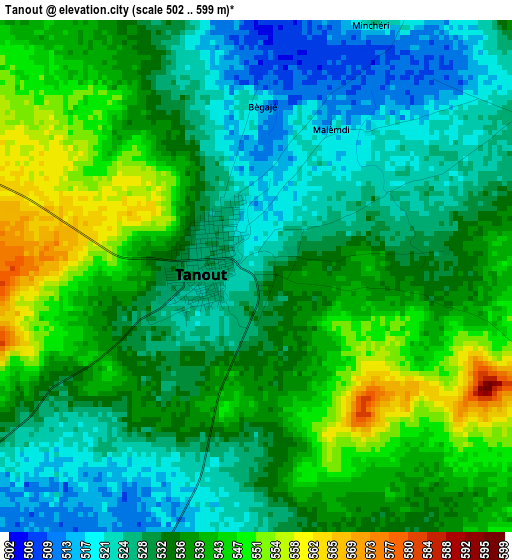
Below is the Elevation map of Tanout, which displays elevation range with different colors. Scale of the first map is from 502 to 599 m (1647 to 1965 ft) with average elevation of 534.4 meters (=1753 ft) [note 1]
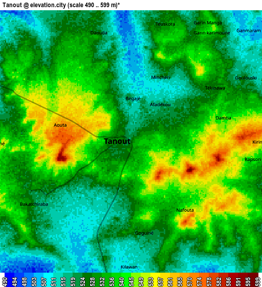
These maps also provides idea of topography and contour of this city, they are displayed at different zoom levels. More info about maps, scale and edge coordinates you can find below images.
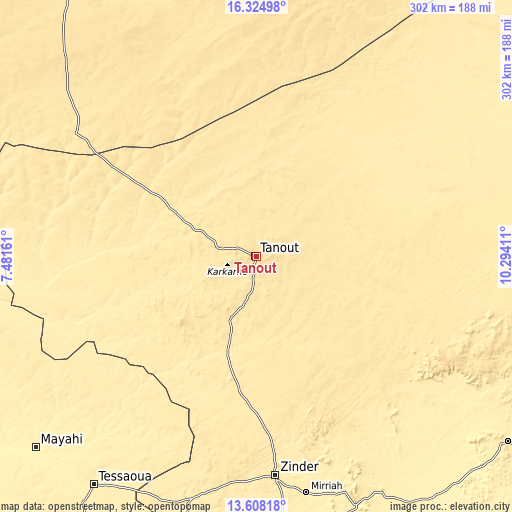
| \ | Map #1 | Map #2 | Topo.Map |
| Scale [m] | 502..599 m | 490..599 m | × |
| Scale [ft] | 1647..1965 ft | 1608..1965 ft | × |
| Average | 534.4 m = 1753 ft | 530.6 m = 1741 ft | × |
| Width | 9.44 km = 5.9 mi | 18.88 km = 11.7 mi | 302.1 km = 187.7 mi |
| Height | 9.44 km = 5.9 mi | 18.88 km = 11.7 mi | 302.1 km = 187.7 mi |
| ↑Max Latitude | 15.013339° | 15.055781° | 16.32498° |
| Latitude at center | 14.97089° | 14.97089° | 14.97089° |
| ↓Min Latitude | 14.928432° | 14.885966° | 13.60818° |
| ← Min Longitude | 8.843915° | 8.799969° | 7.48161° |
| Longitude center | 8.88786° | 8.88786° | 8.88786° |
| →Max Longitude | 8.931805° | 8.975751° | 10.29411° |
Nearby cities:
Cities around Tanout sort by population:
• Zinder elevation 460 m
129.8 km,  175°
175°
• Agadez 505 m
242.4 km,  336°
336°
• Alaghsas 519 m
246 km, 337°
• Tessaoua 400 m
166.2 km,  215°
215°
• Mayahi 389 m
172.9 km,  229°
229°
• Mirriah 407 m
143.3 km,  168°
168°
• Dakoro 416 m
233.9 km,  257°
257°
• Magaria 396 m
219.3 km, 179°
• Matamey 445 m
177.8 km,  194°
194°
• Gouré 447 m
184.9 km,  126°
126°
• Aguié 424 m
202 km, 216°
• Kantché 425 m
165.6 km,  196°
196°
Multilingual:
 En español:
Tanout elevación 525 m.
 En France:
Tanout élévation 525 m.


Sources and notes:
- [note 1] Map square and city borders are not equal. Map elevation data is calculated only from area inside that square.
- [src 1] Elevation data from geonames database provided with same terms of usage.
- [src 2] The elevation map of Tanout is generated using elevation data from NASA's 3 arcsec (90m) resolution SRTM data.
- [src 3] Base (background) map © OpenStreetMap contributors tiles are generated by Geofabrik and OpenTopoMap.
Copyright & License:
This Tanout Elevation Map is licensed under CC BY-SA. You may reuse any part from this page, if you give a proper credit by linking to this URL:
 More info on terms of use page.