Canala elevation
Canala (North Province), New Caledonia elevation is 108 meters and Canala elevation in feet is 354 ft above sea level [src 1]. Canala is a populated place (feature code) with elevation that is 71 meters (233 ft) bigger than average city elevation in New Caledonia.
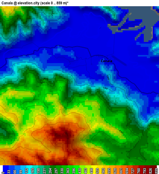
Below is the Elevation map of Canala, which displays elevation range with different colors. Scale of the first map is from 0 to 859 m (0 to 2818 ft) with average elevation of 257.6 meters (=845 ft) [note 1]
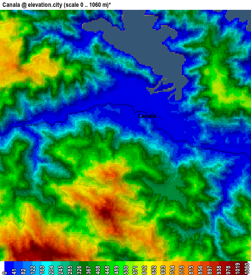
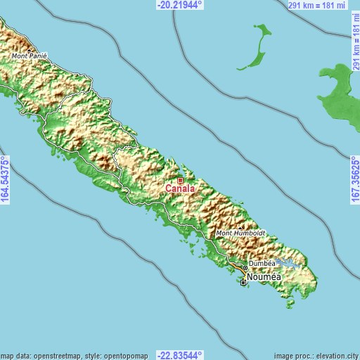
These maps also provides idea of topography and contour of this city, they are displayed at different zoom levels. More info about maps, scale and edge coordinates you can find below images.
| \ | Map #1 | Map #2 | Topo.Map |
| Scale [m] | 0..859 m | 0..1060 m | × |
| Scale [ft] | 0..2818 ft | 0..3478 ft | × |
| Average | 257.6 m = 845 ft | 340.5 m = 1117 ft | × |
| Width | 9.09 km = 5.6 mi | 18.18 km = 11.3 mi | 290.9 km = 180.8 mi |
| Height | 9.09 km = 5.6 mi | 18.18 km = 11.3 mi | 290.9 km = 180.8 mi |
| ↑Max Latitude | -21.492446° | -21.451551° | -20.21944° |
| Latitude at center | -21.53333° | -21.53333° | -21.53333° |
| ↓Min Latitude | -21.574202° | -21.615063° | -22.83544° |
| ← Min Longitude | 165.906055° | 165.862109° | 164.54375° |
| Longitude center | 165.95° | 165.95° | 165.95° |
| →Max Longitude | 165.993945° | 166.037891° | 167.35625° |
Nearby cities:
Cities around Canala sort by population:
• Nouméa elevation 26 m
97.1 km,  148°
148°
• Mont-Dore 11 m
103 km,  141°
141°
• Dumbéa 191 m
86.9 km, 142°
• Païta 11 m
78.6 km, 147°
• Poindimié 26 m
92.4 km,  316°
316°
• Bourail 9 m
47 km,  265°
265°
• Houaïlou 2 m
44.3 km,  308°
308°
• La Foa 24 m
23.4 km,  212°
212°
• Thio 12 m
29.1 km,  108°
108°
• Ponérihouen 19 m
75.8 km, 311°
• Poya 11 m
85.3 km,  283°
283°
• Bouloupari 179 m
38 km,  164°
164°
Multilingual:
 En español:
Canala elevación 108 m.
 En France:
Canala élévation 108 m.


Sources and notes:
- [note 1] Map square and city borders are not equal. Map elevation data is calculated only from area inside that square.
- [src 1] Elevation data from geonames database provided with same terms of usage.
- [src 2] The elevation map of Canala is generated using elevation data from NASA's 3 arcsec (90m) resolution SRTM data.
- [src 3] Base (background) map © OpenStreetMap contributors tiles are generated by Geofabrik and OpenTopoMap.
Copyright & License:
This Canala Elevation Map is licensed under CC BY-SA. You may reuse any part from this page, if you give a proper credit by linking to this URL:
 More info on terms of use page.