Nouméa elevation
Nouméa (South Province), New Caledonia elevation is 26 meters and Nouméa elevation in feet is 85 ft above sea level [src 1]. Nouméa is a capital of a political entity (feature code) with elevation that is 11 meters (36 ft) smaller than average city elevation in New Caledonia.
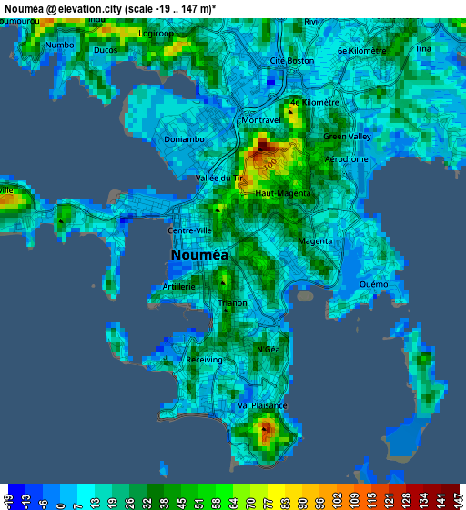
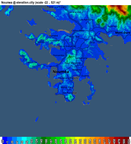
Below is the Elevation map of Nouméa, which displays elevation range with different colors. Scale of the first map is from -19 to 147 m (-62 to 482 ft) with average elevation of 18.9 meters (=62 ft) [note 1]
These maps also provides idea of topography and contour of this city, they are displayed at different zoom levels. More info about maps, scale and edge coordinates you can find below images.
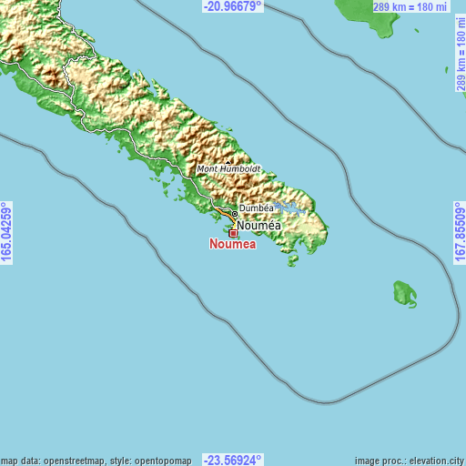
| \ | Map #1 | Map #2 | Topo.Map |
| Scale [m] | -19..147 m | -22..521 m | × |
| Scale [ft] | -62..482 ft | -72..1709 ft | × |
| Average | 18.9 m = 62 ft | 45.5 m = 149 ft | × |
| Width | 9.04 km = 5.6 mi | 18.09 km = 11.2 mi | 289.4 km = 179.8 mi |
| Height | 9.04 km = 5.6 mi | 18.09 km = 11.2 mi | 289.4 km = 179.8 mi |
| ↑Max Latitude | -22.233398° | -22.192714° | -20.96679° |
| Latitude at center | -22.27407° | -22.27407° | -22.27407° |
| ↓Min Latitude | -22.31473° | -22.355379° | -23.56924° |
| ← Min Longitude | 166.404895° | 166.360949° | 165.04259° |
| Longitude center | 166.44884° | 166.44884° | 166.44884° |
| →Max Longitude | 166.492785° | 166.536731° | 167.85509° |
Nearby cities:
Cities around Nouméa sort by population:
• Mont-Dore elevation 11 m
12.1 km,  83°
83°
• Dumbéa 191 m
13 km,  3°
3°
• Païta 11 m
18.5 km,  329°
329°
• Tadine 15 m
168.3 km,  61°
61°
• Bourail 9 m
125.8 km,  308°
308°
• Houaïlou 2 m
139.7 km,  322°
322°
• Canala 108 m
97.1 km, 328°
• La Foa 24 m
89.6 km, 314°
• Thio 12 m
76.9 km,  341°
341°
• Bouloupari 179 m
61.4 km, 318°
• Yaté-Barrage 119 m
46.8 km,  72°
72°
• Vao 14 m
116.1 km,  112°
112°
Multilingual:
 En español:
Numea elevación 26 m.
 En France:
Nouméa élévation 26 m.
 Auf Deutsch:
Noumea, Nouméa höhe über dem Meeresspiegel ist 26 m.

Sources and notes:
- [note 1] Map square and city borders are not equal. Map elevation data is calculated only from area inside that square.
- [src 1] Elevation data from geonames database provided with same terms of usage.
- [src 2] The elevation map of Nouméa is generated using elevation data from NASA's 3 arcsec (90m) resolution SRTM data.
- [src 3] Base (background) map © OpenStreetMap contributors tiles are generated by Geofabrik and OpenTopoMap.
Copyright & License:
This Nouméa Elevation Map is licensed under CC BY-SA. You may reuse any part from this page, if you give a proper credit by linking to this URL:
 More info on terms of use page.