Tsumeb elevation
Tsumeb (Oshikoto), Namibia elevation is 1281 meters and Tsumeb elevation in feet is 4203 ft above sea level [src 1]. Tsumeb is a populated place (feature code) with elevation that is 253 meters (830 ft) bigger than average city elevation in Namibia.
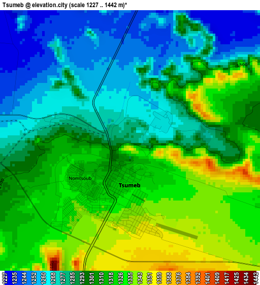
Below is the Elevation map of Tsumeb, which displays elevation range with different colors. Scale of the first map is from 1227 to 1442 m (4026 to 4731 ft) with average elevation of 1300 meters (=4265 ft) [note 1]
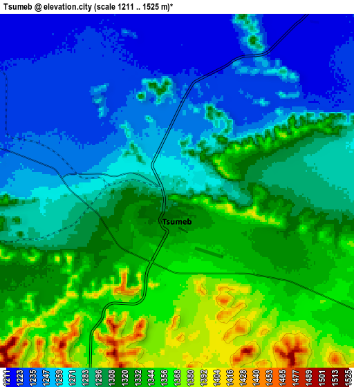
These maps also provides idea of topography and contour of this city, they are displayed at different zoom levels. More info about maps, scale and edge coordinates you can find below images.
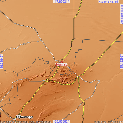
| \ | Map #1 | Map #2 | Topo.Map |
| Scale [m] | 1227..1442 m | 1211..1525 m | × |
| Scale [ft] | 4026..4731 ft | 3973..5003 ft | × |
| Average | 1300 m = 4265 ft | 1298.9 m = 4261 ft | × |
| Width | 9.23 km = 5.7 mi | 18.45 km = 11.5 mi | 295.2 km = 183.4 mi |
| Height | 9.23 km = 5.7 mi | 18.45 km = 11.5 mi | 295.3 km = 183.5 mi |
| ↑Max Latitude | -19.191832° | -19.150324° | -17.90031° |
| Latitude at center | -19.23333° | -19.23333° | -19.23333° |
| ↓Min Latitude | -19.274817° | -19.316294° | -20.55562° |
| ← Min Longitude | 17.672725° | 17.628779° | 16.31042° |
| Longitude center | 17.71667° | 17.71667° | 17.71667° |
| →Max Longitude | 17.760615° | 17.804561° | 19.12292° |
Nearby cities:
Cities around Tsumeb sort by population:
• Rundu elevation 1110 m
259.9 km,  56°
56°
• Oshakati 1103 m
266.1 km,  307°
307°
• Grootfontein 1440 m
56 km,  131°
131°
• Otjiwarongo 1475 m
176.7 km,  219°
219°
• Ongwediva 1098 m
261.3 km, 308°
• Ondangwa 1098 m
236.9 km, 308°
• Outjo 1270 m
191.2 km,  239°
239°
• Okakarara 1347 m
153 km,  191°
191°
• Omuthiya 1098 m
153.6 km, 308°
• Otavi 1414 m
61.3 km, 220°
• Eenhana 1121 m
244.7 km,  323°
323°
• Nkurenkuru 1098 m
202.5 km,  27°
27°
Multilingual:
 En español:
Tsumeb elevación 1281 m.
 En France:
Tsumeb élévation 1281 m.


Sources and notes:
- [note 1] Map square and city borders are not equal. Map elevation data is calculated only from area inside that square.
- [src 1] Elevation data from geonames database provided with same terms of usage.
- [src 2] The elevation map of Tsumeb is generated using elevation data from NASA's 3 arcsec (90m) resolution SRTM data.
- [src 3] Base (background) map © OpenStreetMap contributors tiles are generated by Geofabrik and OpenTopoMap.
Copyright & License:
This Tsumeb Elevation Map is licensed under CC BY-SA. You may reuse any part from this page, if you give a proper credit by linking to this URL:
 More info on terms of use page.