Ixhuatlán del Sureste elevation
Ixhuatlán del Sureste (Veracruz), Mexico elevation is 37 meters and Ixhuatlán del Sureste elevation in feet is 121 ft above sea level [src 1]. Ixhuatlán del Sureste is a seat of a second-order administrative division (feature code) with elevation that is 1277 meters (4190 ft) smaller than average city elevation in Mexico.
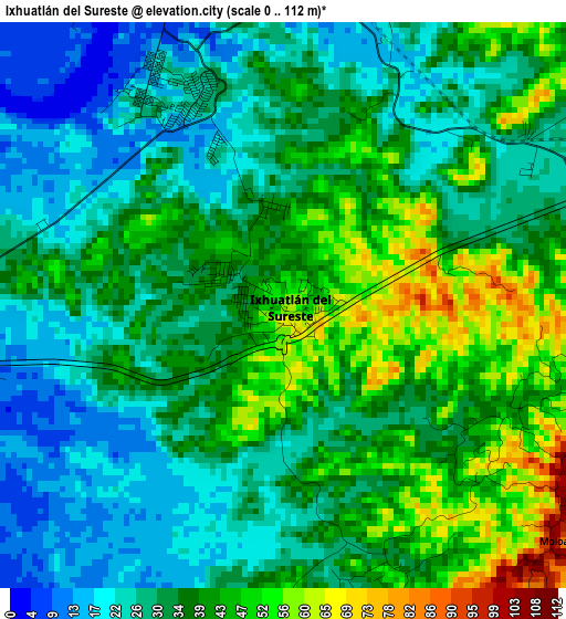
Below is the Elevation map of Ixhuatlán del Sureste, which displays elevation range with different colors. Scale of the first map is from 0 to 112 m (0 to 367 ft) with average elevation of 34.6 meters (=114 ft) [note 1]
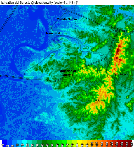
These maps also provides idea of topography and contour of this city, they are displayed at different zoom levels. More info about maps, scale and edge coordinates you can find below images.
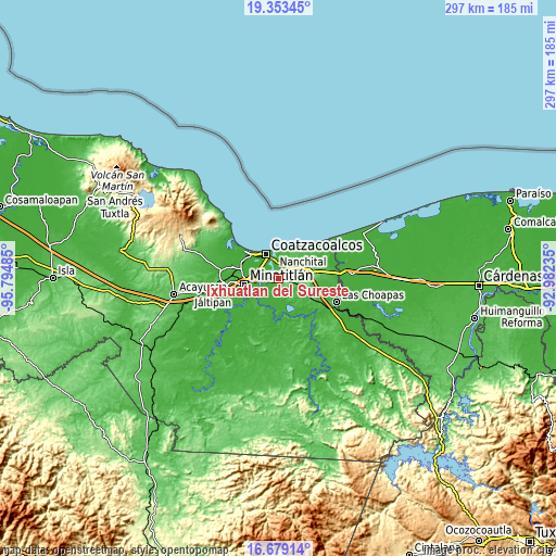
| \ | Map #1 | Map #2 | Topo.Map |
| Scale [m] | 0..112 m | -4..148 m | × |
| Scale [ft] | 0..367 ft | -13..486 ft | × |
| Average | 34.6 m = 114 ft | 28 m = 92 ft | × |
| Width | 9.29 km = 5.8 mi | 18.59 km = 11.6 mi | 297.4 km = 184.8 mi |
| Height | 9.29 km = 5.8 mi | 18.59 km = 11.6 mi | 297.4 km = 184.8 mi |
| ↑Max Latitude | 18.063154° | 18.104929° | 19.35345° |
| Latitude at center | 18.02137° | 18.02137° | 18.02137° |
| ↓Min Latitude | 17.979576° | 17.937771° | 16.67914° |
| ← Min Longitude | -94.432545° | -94.476491° | -95.79485° |
| Longitude center | -94.3886° | -94.3886° | -94.3886° |
| →Max Longitude | -94.344655° | -94.300709° | -92.98235° |
Nearby cities:
Cities around Ixhuatlán del Sureste sort by population:
• Coatzacoalcos elevation 3 m
15.4 km,  337°
337°
• Minatitlán 25 m
18 km,  262°
262°
• Nanchital de Lázaro Cárdenas del Río 16 m
5.9 km, 340°
• Allende 17 m
14.9 km,  358°
358°
• Mundo Nuevo 15 m
7.4 km, 358°
• Cuichapa 34 m
14.7 km,  128°
128°
• Mapachapa 25 m
18.9 km,  272°
272°
• Calzadas 8 m
11.3 km,  321°
321°
• Moloacán 100 m
5.9 km, 132°
• Centro de Readaptación Social 21 m
18.8 km,  313°
313°
• Tlacuilolapan 38 m
14.1 km,  110°
110°
• Guillermo Prieto 26 m
19.5 km,  37°
37°
Multilingual:
 En español:
Ixhuatlán del Sureste, Ixhuatlan del Sureste elevación 37 m.
 En France:
Ixhuatlán del Sureste élévation 37 m.
 Auf Deutsch:
Ixhuatlán del Sureste höhe über dem Meeresspiegel ist 37 m.
 На русском:
Ixhuatlán del Sureste высота над уровнем моря 37 м
Sources and notes:
- [note 1] Map square and city borders are not equal. Map elevation data is calculated only from area inside that square.
- [src 1] Elevation data from geonames database provided with same terms of usage.
- [src 2] The elevation map of Ixhuatlán del Sureste is generated using elevation data from NASA's 3 arcsec (90m) resolution SRTM data.
- [src 3] Base (background) map © OpenStreetMap contributors tiles are generated by Geofabrik and OpenTopoMap.
Copyright & License:
This Ixhuatlán del Sureste Elevation Map is licensed under CC BY-SA. You may reuse any part from this page, if you give a proper credit by linking to this URL:
 More info on terms of use page.