El Naranjito elevation
El Naranjito (Veracruz), Mexico elevation is 29 meters and El Naranjito elevation in feet is 95 ft above sea level [src 1]. El Naranjito is a populated place (feature code) with elevation that is 1285 meters (4216 ft) smaller than average city elevation in Mexico.
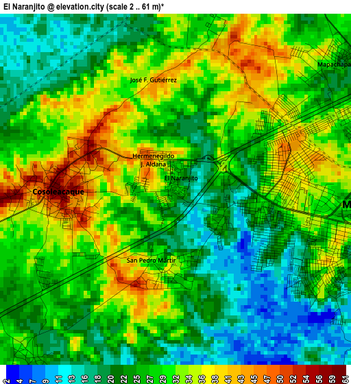
Below is the Elevation map of El Naranjito, which displays elevation range with different colors. Scale of the first map is from 2 to 61 m (7 to 200 ft) with average elevation of 27.5 meters (=90 ft) [note 1]
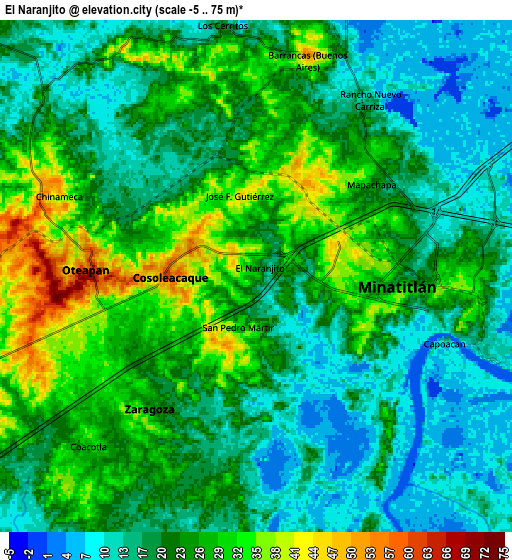
These maps also provides idea of topography and contour of this city, they are displayed at different zoom levels. More info about maps, scale and edge coordinates you can find below images.
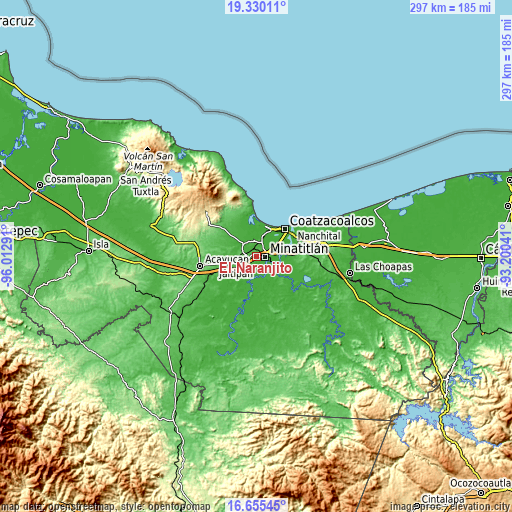
| \ | Map #1 | Map #2 | Topo.Map |
| Scale [m] | 2..61 m | -5..75 m | × |
| Scale [ft] | 7..200 ft | -16..246 ft | × |
| Average | 27.5 m = 90 ft | 21.5 m = 71 ft | × |
| Width | 9.29 km = 5.8 mi | 18.59 km = 11.6 mi | 297.4 km = 184.8 mi |
| Height | 9.29 km = 5.8 mi | 18.59 km = 11.6 mi | 297.4 km = 184.8 mi |
| ↑Max Latitude | 18.03964° | 18.08142° | 19.33011° |
| Latitude at center | 17.99785° | 17.99785° | 17.99785° |
| ↓Min Latitude | 17.95605° | 17.91424° | 16.65545° |
| ← Min Longitude | -94.650605° | -94.694551° | -96.01291° |
| Longitude center | -94.60666° | -94.60666° | -94.60666° |
| →Max Longitude | -94.562715° | -94.518769° | -93.20041° |
Nearby cities:
Cities around El Naranjito sort by population:
• Minatitlán elevation 25 m
5.3 km,  87°
87°
• Cosoleacaque 53 m
3.1 km,  272°
272°
• Oteapan 52 m
6.3 km, 273°
• Zaragoza 25 m
5.8 km,  220°
220°
• Chinameca 50 m
8.2 km,  289°
289°
• San Pedro Mártir 35 m
2.2 km,  190°
190°
• Mapachapa 25 m
5.5 km,  49°
49°
• Fraccionamiento los Prados 26 m
4.1 km,  237°
237°
• Barrancas 49 m
8.2 km,  14°
14°
• Hermenegildo J. Aldana 42 m
1.1 km,  327°
327°
• José F. Gutiérrez 44 m
3.1 km,  352°
352°
• Las Lomas 26 m
7.1 km,  136°
136°
Multilingual:
 En español:
El Naranjito elevación 29 m.
 En France:
El Naranjito élévation 29 m.
 Auf Deutsch:
El Naranjito höhe über dem Meeresspiegel ist 29 m.

Sources and notes:
- [note 1] Map square and city borders are not equal. Map elevation data is calculated only from area inside that square.
- [src 1] Elevation data from geonames database provided with same terms of usage.
- [src 2] The elevation map of El Naranjito is generated using elevation data from NASA's 3 arcsec (90m) resolution SRTM data.
- [src 3] Base (background) map © OpenStreetMap contributors tiles are generated by Geofabrik and OpenTopoMap.
Copyright & License:
This El Naranjito Elevation Map is licensed under CC BY-SA. You may reuse any part from this page, if you give a proper credit by linking to this URL:
 More info on terms of use page.