Benito Juárez elevation
Benito Juárez (Puebla, Los Reyes de Juárez), Mexico elevation is 2255 meters and Benito Juárez elevation in feet is 7398 ft above sea level [src 1]. Benito Juárez is a populated place (feature code) with elevation that is 941 meters (3087 ft) bigger than average city elevation in Mexico.
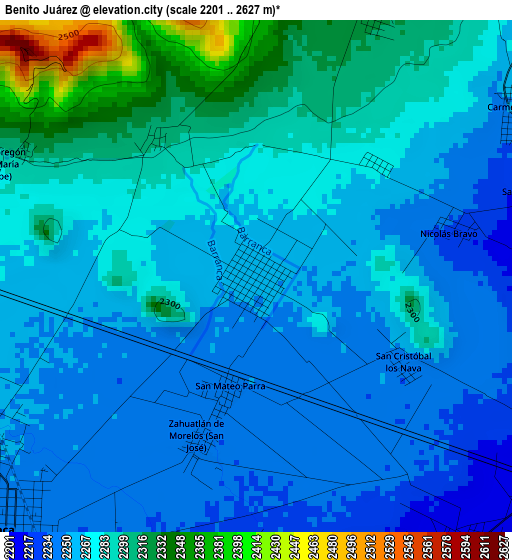
Below is the Elevation map of Benito Juárez, which displays elevation range with different colors. Scale of the first map is from 2201 to 2627 m (7221 to 8619 ft) with average elevation of 2273.4 meters (=7459 ft) [note 1]
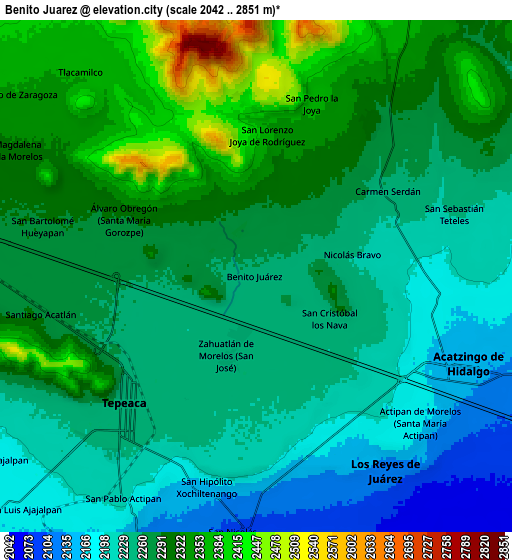
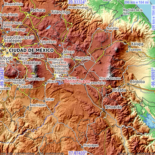
These maps also provides idea of topography and contour of this city, they are displayed at different zoom levels. More info about maps, scale and edge coordinates you can find below images.
| \ | Map #1 | Map #2 | Topo.Map |
| Scale [m] | 2201..2627 m | 2042..2851 m | × |
| Scale [ft] | 7221..8619 ft | 6699..9354 ft | × |
| Average | 2273.4 m = 7459 ft | 2271.8 m = 7453 ft | × |
| Width | 9.24 km = 5.7 mi | 18.48 km = 11.5 mi | 295.6 km = 183.7 mi |
| Height | 9.24 km = 5.7 mi | 18.48 km = 11.5 mi | 295.7 km = 183.7 mi |
| ↑Max Latitude | 19.050644° | 19.092177° | 20.33324° |
| Latitude at center | 19.0091° | 19.0091° | 19.0091° |
| ↓Min Latitude | 18.967546° | 18.925982° | 17.67433° |
| ← Min Longitude | -97.901125° | -97.945071° | -99.26343° |
| Longitude center | -97.85718° | -97.85718° | -97.85718° |
| →Max Longitude | -97.813235° | -97.769289° | -96.45093° |
Nearby cities:
Cities around Benito Juárez sort by population:
• Tepeaca elevation 2244 m
6.5 km,  223°
223°
• Nicolás Bravo 2230 m
3.7 km,  77°
77°
• San José Carpinteros 2262 m
5.9 km,  254°
254°
• San Mateo Parra 2245 m
2 km,  193°
193°
• Zahuatlán de Morelos (San José) 2241 m
3.1 km,  200°
200°
• Álvaro Obregón 2289 m
5.2 km,  293°
293°
• San Lorenzo Joya de Rodríguez 2366 m
5.1 km,  4°
4°
• San Cristóbal Hidalgo 2219 m
5.1 km,  73°
73°
• Carmen Serdán 2255 m
5.6 km,  57°
57°
• San Cristóbal los Nava 2244 m
3.1 km,  120°
120°
• Guadalupe Calderón 2232 m
4.8 km,  181°
181°
• Guadalupe Morelos 2225 m
5.9 km, 71°
Multilingual:
 En español:
Benito Juárez elevación 2255 m.
 En France:
Benito Juárez élévation 2255 m.
 Auf Deutsch:
Benito Juárez höhe über dem Meeresspiegel ist 2255 m.

Sources and notes:
- [note 1] Map square and city borders are not equal. Map elevation data is calculated only from area inside that square.
- [src 1] Elevation data from geonames database provided with same terms of usage.
- [src 2] The elevation map of Benito Juárez is generated using elevation data from NASA's 3 arcsec (90m) resolution SRTM data.
- [src 3] Base (background) map © OpenStreetMap contributors tiles are generated by Geofabrik and OpenTopoMap.
Copyright & License:
This Benito Juárez Elevation Map is licensed under CC BY-SA. You may reuse any part from this page, if you give a proper credit by linking to this URL:
 More info on terms of use page.