Macvilhó elevation
Macvilhó (Chiapas, Chamula), Mexico elevation is 2156 meters and Macvilhó elevation in feet is 7073 ft above sea level [src 1]. Macvilhó is a populated place (feature code) with elevation that is 842 meters (2762 ft) bigger than average city elevation in Mexico.
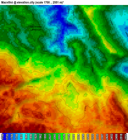
Below is the Elevation map of Macvilhó, which displays elevation range with different colors. Scale of the first map is from 1700 to 2551 m (5577 to 8369 ft) with average elevation of 2128.8 meters (=6984 ft) [note 1]
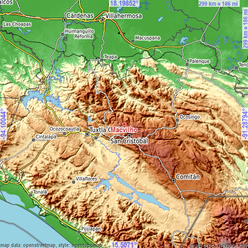
These maps also provides idea of topography and contour of this city, they are displayed at different zoom levels. More info about maps, scale and edge coordinates you can find below images.
| \ | Map #1 | Topo.Map |
| Scale [m] | 1700..2551 m | × |
| Scale [ft] | 5577..8369 ft | × |
| Average | 2128.8 m = 6984 ft | × |
| Width | 9.35 km = 5.8 mi | 299.3 km = 186 mi |
| Height | 9.35 km = 5.8 mi | 299.3 km = 186 mi |
| ↑Max Latitude | 16.899652° | 18.19852° |
| Latitude at center | 16.8576° | 16.8576° |
| ↓Min Latitude | 16.815538° | 15.5071° |
| ← Min Longitude | -92.738135° | -94.10044° |
| Longitude center | -92.69419° | -92.69419° |
| →Max Longitude | -92.650245° | -91.28794° |
Nearby cities:
Cities around Macvilhó sort by population:
• Chamula elevation 2289 m
8.2 km,  176°
176°
• Chenalhó 1526 m
8.2 km,  60°
60°
• Larráinzar 2018 m
3.6 km,  325°
325°
• Chicumtantic 2271 m
9.5 km,  84°
84°
• Belisario Domínguez 1870 m
5.2 km,  43°
43°
• Majomut 2105 m
3.8 km,  104°
104°
• Cuchulumtic 2257 m
9 km,  186°
186°
• Aldama 1820 m
6.6 km,  5°
5°
• Bautista Chico 2398 m
6.7 km,  196°
196°
• Tentic 2034 m
1.4 km, 63°
• Arvenza Uno 2314 m
9.1 km, 197°
• Santiago el Pinar 1682 m
9.5 km,  346°
346°
Multilingual:
 En español:
Teatiks, Macvilhó elevación 2156 m.
 En France:
Macvilhó élévation 2156 m.
 Auf Deutsch:
Macvilhó höhe über dem Meeresspiegel ist 2156 m.

Sources and notes:
- [note 1] Map square and city borders are not equal. Map elevation data is calculated only from area inside that square.
- [src 1] Elevation data from geonames database provided with same terms of usage.
- [src 2] The elevation map of Macvilhó is generated using elevation data from NASA's 3 arcsec (90m) resolution SRTM data.
- [src 3] Base (background) map © OpenStreetMap contributors tiles are generated by Geofabrik and OpenTopoMap.
Copyright & License:
This Macvilhó Elevation Map is licensed under CC BY-SA. You may reuse any part from this page, if you give a proper credit by linking to this URL:
 More info on terms of use page.