San Bartolo Coyotespec elevation
San Bartolo Coyotespec (Oaxaca, San Bartolo Coyotepec), Mexico elevation is 1525 meters and San Bartolo Coyotespec elevation in feet is 5003 ft above sea level [src 1]. San Bartolo Coyotespec is a populated place (feature code) with elevation that is 211 meters (692 ft) bigger than average city elevation in Mexico.
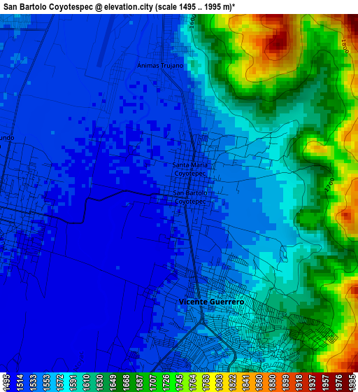
Below is the Elevation map of San Bartolo Coyotespec, which displays elevation range with different colors. Scale of the first map is from 1495 to 1995 m (4905 to 6545 ft) with average elevation of 1578.5 meters (=5179 ft) [note 1]
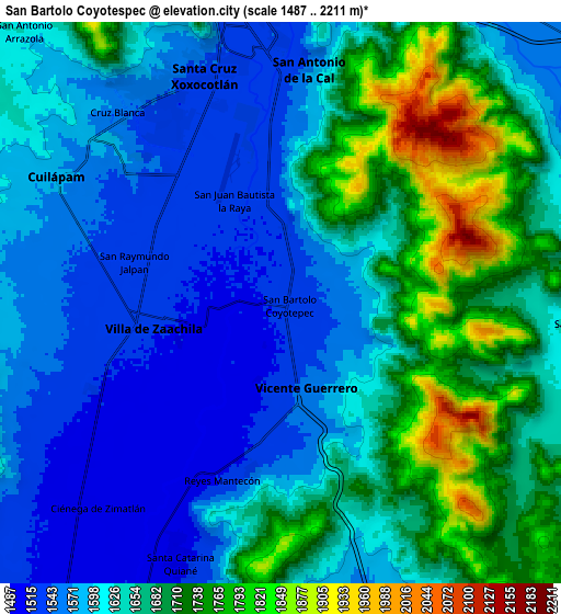
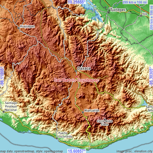
These maps also provides idea of topography and contour of this city, they are displayed at different zoom levels. More info about maps, scale and edge coordinates you can find below images.
| \ | Map #1 | Map #2 | Topo.Map |
| Scale [m] | 1495..1995 m | 1487..2211 m | × |
| Scale [ft] | 4905..6545 ft | 4879..7254 ft | × |
| Average | 1578.5 m = 5179 ft | 1640 m = 5381 ft | × |
| Width | 9.35 km = 5.8 mi | 18.7 km = 11.6 mi | 299.1 km = 185.9 mi |
| Height | 9.35 km = 5.8 mi | 18.7 km = 11.6 mi | 299.1 km = 185.9 mi |
| ↑Max Latitude | 17.0004° | 17.04242° | 18.29855° |
| Latitude at center | 16.95837° | 16.95837° | 16.95837° |
| ↓Min Latitude | 16.916331° | 16.874282° | 15.60857° |
| ← Min Longitude | -96.753245° | -96.797191° | -98.11555° |
| Longitude center | -96.7093° | -96.7093° | -96.7093° |
| →Max Longitude | -96.665355° | -96.621409° | -95.30305° |
Nearby cities:
Cities around San Bartolo Coyotespec sort by population:
• Villa de Zaachila elevation 1518 m
4.3 km,  259°
259°
• Vicente Guerrero 1557 m
2.9 km,  163°
163°
• San Agustín de las Juntas 1536 m
6 km,  357°
357°
• San Agustin de las Juntas 1558 m
5.1 km,  1°
1°
• Reyes Mantecón 1514 m
6 km,  198°
198°
• Animas Trujano 1527 m
3.6 km,  353°
353°
• San Juan Bautista la Raya 1522 m
3.5 km,  332°
332°
• Santa María Coyotepec 1527 m
1 km,  25°
25°
• San Raymundo Jalpam 1531 m
5.3 km,  286°
286°
• Fraccionamiento Real del Valle 1515 m
6.8 km,  245°
245°
• San Isidro Monjas 1544 m
6.4 km,  319°
319°
• Trinidad Zaachila 1510 m
7.1 km,  234°
234°
Multilingual:
 En español:
San Bartolo Coyotespec elevación 1525 m.
 En France:
San Bartolo Coyotespec élévation 1525 m.
 Auf Deutsch:
San Bartolo Coyotespec höhe über dem Meeresspiegel ist 1525 m.
 На русском:
San Bartolo Coyotespec высота над уровнем моря 1525 м
Sources and notes:
- [note 1] Map square and city borders are not equal. Map elevation data is calculated only from area inside that square.
- [src 1] Elevation data from geonames database provided with same terms of usage.
- [src 2] The elevation map of San Bartolo Coyotespec is generated using elevation data from NASA's 3 arcsec (90m) resolution SRTM data.
- [src 3] Base (background) map © OpenStreetMap contributors tiles are generated by Geofabrik and OpenTopoMap.
Copyright & License:
This San Bartolo Coyotespec Elevation Map is licensed under CC BY-SA. You may reuse any part from this page, if you give a proper credit by linking to this URL:
 More info on terms of use page.