Ventoquipa elevation
Ventoquipa (Hidalgo, Santiago Tulantepec de Lugo Guerrero), Mexico elevation is 2219 meters and Ventoquipa elevation in feet is 7280 ft above sea level [src 1]. Ventoquipa is a populated place (feature code) with elevation that is 905 meters (2969 ft) bigger than average city elevation in Mexico.
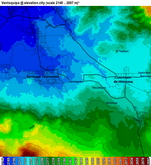
Below is the Elevation map of Ventoquipa, which displays elevation range with different colors. Scale of the first map is from 2148 to 2697 m (7047 to 8848 ft) with average elevation of 2279.7 meters (=7479 ft) [note 1]
These maps also provides idea of topography and contour of this city, they are displayed at different zoom levels. More info about maps, scale and edge coordinates you can find below images.
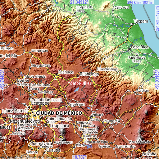
| \ | Map #1 | Topo.Map |
| Scale [m] | 2148..2697 m | × |
| Scale [ft] | 7047..8848 ft | × |
| Average | 2279.7 m = 7479 ft | × |
| Width | 9.18 km = 5.7 mi | 293.8 km = 182.6 mi |
| Height | 9.18 km = 5.7 mi | 293.8 km = 182.6 mi |
| ↑Max Latitude | 20.074891° | 21.34912° |
| Latitude at center | 20.03361° | 20.03361° |
| ↓Min Latitude | 19.992318° | 18.707° |
| ← Min Longitude | -98.381725° | -99.74403° |
| Longitude center | -98.33778° | -98.33778° |
| →Max Longitude | -98.293835° | -96.93153° |
Nearby cities:
Cities around Ventoquipa sort by population:
• Tulancingo elevation 2187 m
6.1 km,  334°
334°
• Cuautepec de Hinojosa 2250 m
2.9 km,  85°
85°
• Santiago Tulantepec 2196 m
1.9 km,  278°
278°
• Santa María Nativitas 2283 m
4.5 km,  82°
82°
• Almoloya 2277 m
2.5 km,  118°
118°
• San Lorenzo Sayula 2360 m
6.5 km,  139°
139°
• Guadalupe Victoria 2287 m
7.2 km, 86°
• Texcaltepec 2260 m
1.5 km,  104°
104°
• El Tepeyac 2270 m
3.4 km,  56°
56°
• El Capulín 2374 m
7 km,  113°
113°
• San Juan Hueyapan 2264 m
5.8 km, 93°
• Fraccionamiento del Magisterio Tulancinguense 2156 m
8 km,  306°
306°
Multilingual:
 En español:
Ventoquipa elevación 2219 m.
 En France:
Ventoquipa élévation 2219 m.
 Auf Deutsch:
Ventoquipa höhe über dem Meeresspiegel ist 2219 m.

Sources and notes:
- [note 1] Map square and city borders are not equal. Map elevation data is calculated only from area inside that square.
- [src 1] Elevation data from geonames database provided with same terms of usage.
- [src 2] The elevation map of Ventoquipa is generated using elevation data from NASA's 3 arcsec (90m) resolution SRTM data.
- [src 3] Base (background) map © OpenStreetMap contributors tiles are generated by Geofabrik and OpenTopoMap.
Copyright & License:
This Ventoquipa Elevation Map is licensed under CC BY-SA. You may reuse any part from this page, if you give a proper credit by linking to this URL:
 More info on terms of use page.