Tulimanca elevation
Tulimanca (Puebla, Vicente Guerrero), Mexico elevation is 2443 meters and Tulimanca elevation in feet is 8015 ft above sea level [src 1]. Tulimanca is a populated place (feature code) with elevation that is 1129 meters (3704 ft) bigger than average city elevation in Mexico.
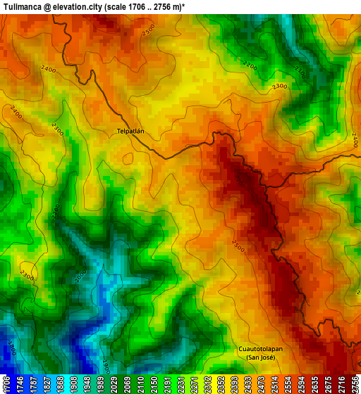
Below is the Elevation map of Tulimanca, which displays elevation range with different colors. Scale of the first map is from 1706 to 2756 m (5597 to 9042 ft) with average elevation of 2319.3 meters (=7609 ft) [note 1]
These maps also provides idea of topography and contour of this city, they are displayed at different zoom levels. More info about maps, scale and edge coordinates you can find below images.
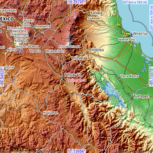
| \ | Map #1 | Topo.Map |
| Scale [m] | 1706..2756 m | × |
| Scale [ft] | 5597..9042 ft | × |
| Average | 2319.3 m = 7609 ft | × |
| Width | 9.27 km = 5.8 mi | 296.6 km = 184.3 mi |
| Height | 9.27 km = 5.8 mi | 296.6 km = 184.3 mi |
| ↑Max Latitude | 18.511117° | 19.79797° |
| Latitude at center | 18.46944° | 18.46944° |
| ↓Min Latitude | 18.427753° | 17.13054° |
| ← Min Longitude | -97.183945° | -98.54625° |
| Longitude center | -97.14° | -97.14° |
| →Max Longitude | -97.096055° | -95.73375° |
Nearby cities:
Cities around Tulimanca sort by population:
• Tepetzitzintla elevation 2609 m
2.2 km,  83°
83°
• Santa María del Monte 2615 m
10.2 km,  321°
321°
• Telpatlán 2434 m
2.1 km, 321°
• Tecpantzacoalco 2123 m
10.6 km,  85°
85°
• Tehuipango 2358 m
10.6 km,  58°
58°
• Xopilapa 2483 m
7.5 km, 58°
• Cuaxuxpa 2309 m
11 km, 94°
• Cuautotolapan (San José) 2408 m
4.5 km,  153°
153°
• Alhuaca 2683 m
11.3 km,  345°
345°
• Coxolico 2317 m
11.8 km,  99°
99°
• Cuatro Caminos 2421 m
2.7 km,  25°
25°
• Astacinga 2317 m
11.7 km,  19°
19°
Multilingual:
 En español:
Tulimanca elevación 2443 m.
 En France:
Tulimanca élévation 2443 m.
 Auf Deutsch:
Tulimanca höhe über dem Meeresspiegel ist 2443 m.

Sources and notes:
- [note 1] Map square and city borders are not equal. Map elevation data is calculated only from area inside that square.
- [src 1] Elevation data from geonames database provided with same terms of usage.
- [src 2] The elevation map of Tulimanca is generated using elevation data from NASA's 3 arcsec (90m) resolution SRTM data.
- [src 3] Base (background) map © OpenStreetMap contributors tiles are generated by Geofabrik and OpenTopoMap.
Copyright & License:
This Tulimanca Elevation Map is licensed under CC BY-SA. You may reuse any part from this page, if you give a proper credit by linking to this URL:
 More info on terms of use page.