San Lorenzo elevation
San Lorenzo (Oaxaca, San Juan Lalana), Mexico elevation is 94 meters and San Lorenzo elevation in feet is 308 ft above sea level [src 1]. San Lorenzo is a populated place (feature code) with elevation that is 1220 meters (4003 ft) smaller than average city elevation in Mexico.
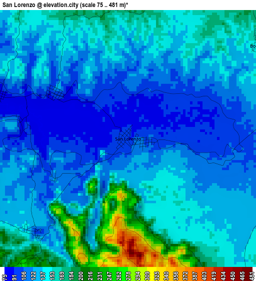
Below is the Elevation map of San Lorenzo, which displays elevation range with different colors. Scale of the first map is from 75 to 481 m (246 to 1578 ft) with average elevation of 140.2 meters (=460 ft) [note 1]
These maps also provides idea of topography and contour of this city, they are displayed at different zoom levels. More info about maps, scale and edge coordinates you can find below images.
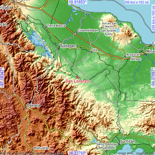
| \ | Map #1 | Topo.Map |
| Scale [m] | 75..481 m | × |
| Scale [ft] | 246..1578 ft | × |
| Average | 140.2 m = 460 ft | × |
| Width | 9.32 km = 5.8 mi | 298.1 km = 185.2 mi |
| Height | 9.32 km = 5.8 mi | 298.1 km = 185.2 mi |
| ↑Max Latitude | 17.624947° | 18.91853° |
| Latitude at center | 17.58306° | 17.58306° |
| ↓Min Latitude | 17.541163° | 16.23765° |
| ← Min Longitude | -95.821165° | -97.18347° |
| Longitude center | -95.77722° | -95.77722° |
| →Max Longitude | -95.733275° | -94.37097° |
Nearby cities:
Cities around San Lorenzo sort by population:
• El Nigromante elevation 148 m
20.3 km,  5°
5°
• Río Chiquito 82 m
17.4 km,  283°
283°
• San José Río Manzo 89 m
14.6 km,  311°
311°
• Arenal Santa Ana 80 m
23 km,  1°
1°
• Tatahuicapá 95 m
14.9 km,  103°
103°
• Ignacio Zaragoza 248 m
13.4 km,  246°
246°
• Montenegro la Lana 79 m
9.4 km, 276°
• San Juan del Río 158 m
10.2 km,  169°
169°
• Santa Teresa 104 m
16.7 km,  41°
41°
• Boca del Monte 162 m
6 km,  54°
54°
• La Nueva Era 80 m
13.3 km,  345°
345°
• Xochiapa 147 m
10 km,  26°
26°
Multilingual:
 En español:
San Lorenzo elevación 94 m.
 En France:
San Lorenzo élévation 94 m.
 Auf Deutsch:
San Lorenzo höhe über dem Meeresspiegel ist 94 m.

Sources and notes:
- [note 1] Map square and city borders are not equal. Map elevation data is calculated only from area inside that square.
- [src 1] Elevation data from geonames database provided with same terms of usage.
- [src 2] The elevation map of San Lorenzo is generated using elevation data from NASA's 3 arcsec (90m) resolution SRTM data.
- [src 3] Base (background) map © OpenStreetMap contributors tiles are generated by Geofabrik and OpenTopoMap.
Copyright & License:
This San Lorenzo Elevation Map is licensed under CC BY-SA. You may reuse any part from this page, if you give a proper credit by linking to this URL:
 More info on terms of use page.