Cerritos elevation
Cerritos (Hidalgo, Santiago de Anaya), Mexico elevation is 1958 meters and Cerritos elevation in feet is 6424 ft above sea level [src 1]. Cerritos is a populated place (feature code) with elevation that is 644 meters (2113 ft) bigger than average city elevation in Mexico.
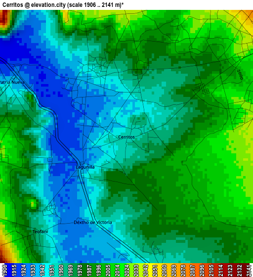
Below is the Elevation map of Cerritos, which displays elevation range with different colors. Scale of the first map is from 1906 to 2141 m (6253 to 7024 ft) with average elevation of 1974.1 meters (=6477 ft) [note 1]
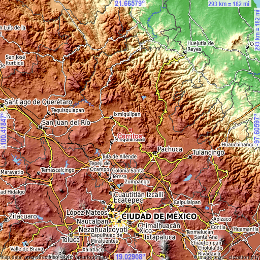
These maps also provides idea of topography and contour of this city, they are displayed at different zoom levels. More info about maps, scale and edge coordinates you can find below images.
| \ | Map #1 | Topo.Map |
| Scale [m] | 1906..2141 m | × |
| Scale [ft] | 6253..7024 ft | × |
| Average | 1974.1 m = 6477 ft | × |
| Width | 9.16 km = 5.7 mi | 293.2 km = 182.2 mi |
| Height | 9.16 km = 5.7 mi | 293.2 km = 182.2 mi |
| ↑Max Latitude | 20.394256° | 21.66579° |
| Latitude at center | 20.35306° | 20.35306° |
| ↓Min Latitude | 20.311853° | 19.02908° |
| ← Min Longitude | -99.056165° | -100.41847° |
| Longitude center | -99.01222° | -99.01222° |
| →Max Longitude | -98.968275° | -97.60597° |
Nearby cities:
Cities around Cerritos sort by population:
• Caxuxi elevation 1967 m
5.8 km,  157°
157°
• Yolotepec 1931 m
7.4 km,  301°
301°
• Daxtha 1958 m
8.8 km, 157°
• Santiago de Anaya 2042 m
6 km,  54°
54°
• Dajiedi 2049 m
8.9 km,  121°
121°
• Patria Nueva 1937 m
4.6 km, 296°
• Lagunilla 1932 m
1.9 km,  234°
234°
• Déxtho de Victoria 1947 m
3.3 km,  201°
201°
• Julián Villagrán 1941 m
10.7 km, 296°
• Teofani 1966 m
4.6 km,  223°
223°
• San Salvador 1949 m
7.5 km,  181°
181°
• El Olvera 1955 m
9.3 km,  188°
188°
Multilingual:
 En español:
Cerritos elevación 1958 m.
 En France:
Cerritos élévation 1958 m.
 Auf Deutsch:
Cerritos höhe über dem Meeresspiegel ist 1958 m.

Sources and notes:
- [note 1] Map square and city borders are not equal. Map elevation data is calculated only from area inside that square.
- [src 1] Elevation data from geonames database provided with same terms of usage.
- [src 2] The elevation map of Cerritos is generated using elevation data from NASA's 3 arcsec (90m) resolution SRTM data.
- [src 3] Base (background) map © OpenStreetMap contributors tiles are generated by Geofabrik and OpenTopoMap.
Copyright & License:
This Cerritos Elevation Map is licensed under CC BY-SA. You may reuse any part from this page, if you give a proper credit by linking to this URL:
 More info on terms of use page.