Romerillo elevation
Romerillo (Chiapas, Chamula), Mexico elevation is 2438 meters and Romerillo elevation in feet is 7999 ft above sea level [src 1]. Romerillo is a populated place (feature code) with elevation that is 1124 meters (3688 ft) bigger than average city elevation in Mexico.
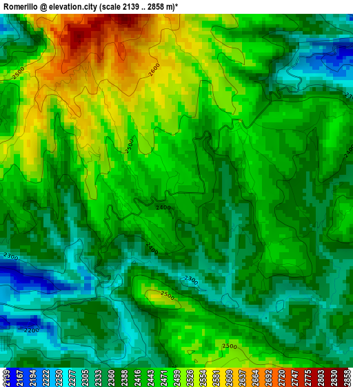
Below is the Elevation map of Romerillo, which displays elevation range with different colors. Scale of the first map is from 2139 to 2858 m (7018 to 9377 ft) with average elevation of 2424.5 meters (=7954 ft) [note 1]
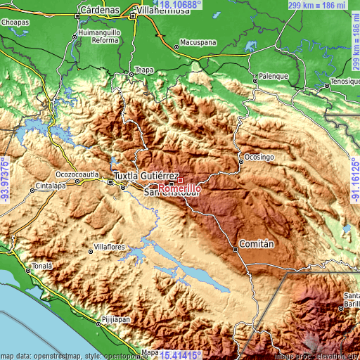
These maps also provides idea of topography and contour of this city, they are displayed at different zoom levels. More info about maps, scale and edge coordinates you can find below images.
| \ | Map #1 | Topo.Map |
| Scale [m] | 2139..2858 m | × |
| Scale [ft] | 7018..9377 ft | × |
| Average | 2424.5 m = 7954 ft | × |
| Width | 9.36 km = 5.8 mi | 299.4 km = 186 mi |
| Height | 9.36 km = 5.8 mi | 299.4 km = 186 mi |
| ↑Max Latitude | 16.807353° | 18.10688° |
| Latitude at center | 16.76528° | 16.76528° |
| ↓Min Latitude | 16.723198° | 15.41415° |
| ← Min Longitude | -92.611445° | -93.97375° |
| Longitude center | -92.5675° | -92.5675° |
| →Max Longitude | -92.523555° | -91.16125° |
Nearby cities:
Cities around Romerillo sort by population:
• San Cristóbal de las Casas elevation 2125 m
8.7 km,  244°
244°
• San Antonio del Monte 2243 m
9.1 km,  266°
266°
• Tenejapa 2013 m
8.8 km,  47°
47°
• La Candelaria 2408 m
5.5 km,  116°
116°
• Cruztón 2459 m
1.3 km,  252°
252°
• Chicumtantic 2271 m
11.9 km,  340°
340°
• Matzam 2384 m
10 km,  74°
74°
• Muquén 2310 m
6.4 km,  315°
315°
• Saclamantón 2448 m
7.6 km,  289°
289°
• Las Ollas 2500 m
2.4 km,  41°
41°
• Oxinam 2031 m
11 km,  10°
10°
• Tzontehuitz 2578 m
7.7 km,  350°
350°
Multilingual:
 En español:
Romerillo elevación 2438 m.
 En France:
Romerillo élévation 2438 m.
 Auf Deutsch:
Romerillo höhe über dem Meeresspiegel ist 2438 m.

Sources and notes:
- [note 1] Map square and city borders are not equal. Map elevation data is calculated only from area inside that square.
- [src 1] Elevation data from geonames database provided with same terms of usage.
- [src 2] The elevation map of Romerillo is generated using elevation data from NASA's 3 arcsec (90m) resolution SRTM data.
- [src 3] Base (background) map © OpenStreetMap contributors tiles are generated by Geofabrik and OpenTopoMap.
Copyright & License:
This Romerillo Elevation Map is licensed under CC BY-SA. You may reuse any part from this page, if you give a proper credit by linking to this URL:
 More info on terms of use page.