Ex-Hacienda de Guadalupe elevation
Ex-Hacienda de Guadalupe (State of Mexico, Zumpango), Mexico elevation is 2271 meters and Ex-Hacienda de Guadalupe elevation in feet is 7451 ft above sea level [src 1]. Ex-Hacienda de Guadalupe is a populated place (feature code) with elevation that is 957 meters (3140 ft) bigger than average city elevation in Mexico.
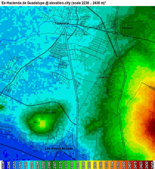
Below is the Elevation map of Ex-Hacienda de Guadalupe, which displays elevation range with different colors. Scale of the first map is from 2238 to 2438 m (7343 to 7999 ft) with average elevation of 2291.4 meters (=7518 ft) [note 1]
These maps also provides idea of topography and contour of this city, they are displayed at different zoom levels. More info about maps, scale and edge coordinates you can find below images.
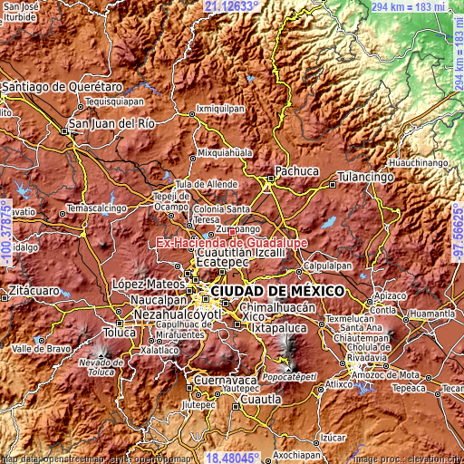
| \ | Map #1 | Topo.Map |
| Scale [m] | 2238..2438 m | × |
| Scale [ft] | 7343..7999 ft | × |
| Average | 2291.4 m = 7518 ft | × |
| Width | 9.19 km = 5.7 mi | 294.2 km = 182.8 mi |
| Height | 9.19 km = 5.7 mi | 294.2 km = 182.8 mi |
| ↑Max Latitude | 19.85023° | 21.12633° |
| Latitude at center | 19.80889° | 19.80889° |
| ↓Min Latitude | 19.76754° | 18.48045° |
| ← Min Longitude | -99.016445° | -100.37875° |
| Longitude center | -98.9725° | -98.9725° |
| →Max Longitude | -98.928555° | -97.56625° |
Nearby cities:
Cities around Ex-Hacienda de Guadalupe sort by population:
• Tizayuca elevation 2275 m
3.2 km,  353°
353°
• Reyes Acozac 2259 m
3.8 km,  193°
193°
• Santa María Ajoloapan 2283 m
5.2 km,  164°
164°
• San Bartolo Cuautlalpan 2269 m
4 km,  279°
279°
• Paseos de San Juan 2253 m
5.6 km,  237°
237°
• Temascalapa 2355 m
7.7 km,  74°
74°
• Arbolada los Sauces 2265 m
7.5 km, 275°
• Huitzila 2300 m
1.8 km,  81°
81°
• Tepojaco 2303 m
4.4 km,  36°
36°
• Sanata Lucía 2251 m
6.8 km, 187°
• San Juan Pueblo Nuevo 2251 m
6.2 km,  233°
233°
• San Miguel Atlamajac 2305 m
7.8 km,  148°
148°
Multilingual:
 En español:
Ex-Hacienda de Guadalupe elevación 2271 m.
 En France:
Ex-Hacienda de Guadalupe élévation 2271 m.
 Auf Deutsch:
Ex-Hacienda de Guadalupe höhe über dem Meeresspiegel ist 2271 m.
 На русском:
Ex-Hacienda de Guadalupe высота над уровнем моря 2271 м
Sources and notes:
- [note 1] Map square and city borders are not equal. Map elevation data is calculated only from area inside that square.
- [src 1] Elevation data from geonames database provided with same terms of usage.
- [src 2] The elevation map of Ex-Hacienda de Guadalupe is generated using elevation data from NASA's 3 arcsec (90m) resolution SRTM data.
- [src 3] Base (background) map © OpenStreetMap contributors tiles are generated by Geofabrik and OpenTopoMap.
Copyright & License:
This Ex-Hacienda de Guadalupe Elevation Map is licensed under CC BY-SA. You may reuse any part from this page, if you give a proper credit by linking to this URL:
 More info on terms of use page.