Chula Vista elevation
Chula Vista (Coahuila, Ocampo), Mexico elevation is 1043 meters and Chula Vista elevation in feet is 3422 ft above sea level [src 1]. Chula Vista is a populated place (feature code) with elevation that is 271 meters (889 ft) smaller than average city elevation in Mexico.
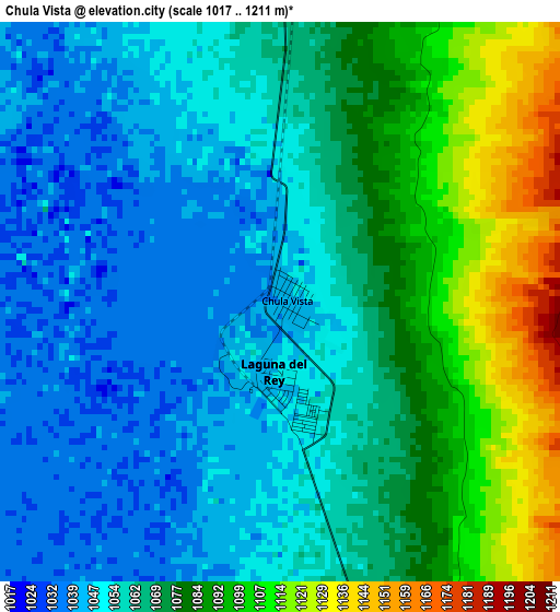
Below is the Elevation map of Chula Vista, which displays elevation range with different colors. Scale of the first map is from 1017 to 1211 m (3337 to 3973 ft) with average elevation of 1068.1 meters (=3504 ft) [note 1]
These maps also provides idea of topography and contour of this city, they are displayed at different zoom levels. More info about maps, scale and edge coordinates you can find below images.
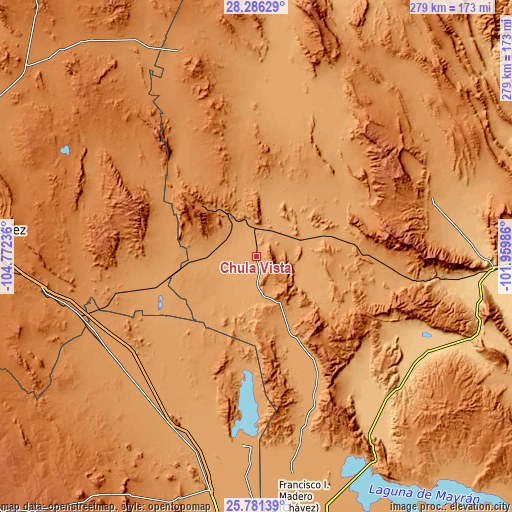
| \ | Map #1 | Topo.Map |
| Scale [m] | 1017..1211 m | × |
| Scale [ft] | 3337..3973 ft | × |
| Average | 1068.1 m = 3504 ft | × |
| Width | 8.7 km = 5.4 mi | 278.5 km = 173.1 mi |
| Height | 8.7 km = 5.4 mi | 278.5 km = 173.1 mi |
| ↑Max Latitude | 27.079965° | 28.28629° |
| Latitude at center | 27.04083° | 27.04083° |
| ↓Min Latitude | 27.001682° | 25.78139° |
| ← Min Longitude | -103.410055° | -104.77236° |
| Longitude center | -103.36611° | -103.36611° |
| →Max Longitude | -103.322165° | -101.95986° |
Nearby cities:
Cities around Chula Vista sort by population:
• Cuatro Ciénegas de Carranza elevation 739 m
129.1 km,  92°
92°
• Tlahualilo de Zaragoza 1094 m
104.2 km,  184°
184°
• Hércules 1341 m
119.1 km,  339°
339°
• Ceballos 1186 m
95 km,  232°
232°
• Ocampo 1122 m
100.6 km,  72°
72°
• Laguna del Rey (Químicas del Rey) 1047 m
1.1 km, 182°
• San Francisco de Horizonte (Horizonte) 1100 m
122.8 km, 182°
• La Pinta 1104 m
126.9 km, 175°
• La Esmeralda 1397 m
40.2 km,  313°
313°
• Jauja 1100 m
123.6 km, 180°
• San Julio 1099 m
122.9 km, 182°
• Sierra Mojada 1530 m
43.1 km, 309°
Multilingual:
 En español:
Chula Vista elevación 1043 m.
 En France:
Chula Vista élévation 1043 m.
 Auf Deutsch:
Chula Vista höhe über dem Meeresspiegel ist 1043 m.

Sources and notes:
- [note 1] Map square and city borders are not equal. Map elevation data is calculated only from area inside that square.
- [src 1] Elevation data from geonames database provided with same terms of usage.
- [src 2] The elevation map of Chula Vista is generated using elevation data from NASA's 3 arcsec (90m) resolution SRTM data.
- [src 3] Base (background) map © OpenStreetMap contributors tiles are generated by Geofabrik and OpenTopoMap.
Copyright & License:
This Chula Vista Elevation Map is licensed under CC BY-SA. You may reuse any part from this page, if you give a proper credit by linking to this URL:
 More info on terms of use page.