El Llano Santa María elevation
El Llano Santa María (State of Mexico, Zumpango), Mexico elevation is 2254 meters and El Llano Santa María elevation in feet is 7395 ft above sea level [src 1]. El Llano Santa María is a populated place (feature code) with elevation that is 940 meters (3084 ft) bigger than average city elevation in Mexico.
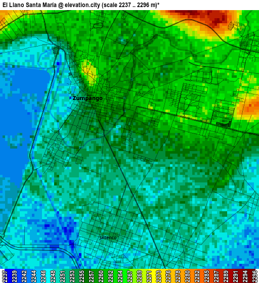
Below is the Elevation map of El Llano Santa María, which displays elevation range with different colors. Scale of the first map is from 2237 to 2296 m (7339 to 7533 ft) with average elevation of 2254.7 meters (=7397 ft) [note 1]
These maps also provides idea of topography and contour of this city, they are displayed at different zoom levels. More info about maps, scale and edge coordinates you can find below images.

| \ | Map #1 | Topo.Map |
| Scale [m] | 2237..2296 m | × |
| Scale [ft] | 7339..7533 ft | × |
| Average | 2254.7 m = 7397 ft | × |
| Width | 9.2 km = 5.7 mi | 294.2 km = 182.8 mi |
| Height | 9.2 km = 5.7 mi | 294.3 km = 182.9 mi |
| ↑Max Latitude | 19.825236° | 21.10154° |
| Latitude at center | 19.78389° | 19.78389° |
| ↓Min Latitude | 19.742533° | 18.45525° |
| ← Min Longitude | -99.130335° | -100.49264° |
| Longitude center | -99.08639° | -99.08639° |
| →Max Longitude | -99.042445° | -97.68014° |
Nearby cities:
Cities around El Llano Santa María sort by population:
• Zumpango elevation 2258 m
2 km,  316°
316°
• Santa Ana Nextlalpan 2251 m
4.8 km,  165°
165°
• Jaltenco 2253 m
3.5 km,  192°
192°
• Fraccionamiento la Trinidad 2269 m
5 km,  4°
4°
• San Sebastián 2261 m
3.2 km,  89°
89°
• Arbolada los Sauces 2265 m
5.7 km,  51°
51°
• Santa María de Guadalupe 2269 m
6 km,  313°
313°
• Villas de la Laguna 2269 m
5.8 km,  356°
356°
• Prados San Francisco 2242 m
6.9 km,  177°
177°
• Colonia los Aguiluchos 2244 m
6.4 km, 183°
• Colonia Wenceslao Labra 2287 m
6.3 km, 320°
• Pueblo Nuevo de Morelos 2249 m
4.2 km,  124°
124°
Multilingual:
 En español:
El Llano Santa María elevación 2254 m.
 En France:
El Llano Santa María élévation 2254 m.
 Auf Deutsch:
El Llano Santa María höhe über dem Meeresspiegel ist 2254 m.
 На русском:
El Llano Santa María высота над уровнем моря 2254 м
Sources and notes:
- [note 1] Map square and city borders are not equal. Map elevation data is calculated only from area inside that square.
- [src 1] Elevation data from geonames database provided with same terms of usage.
- [src 2] The elevation map of El Llano Santa María is generated using elevation data from NASA's 3 arcsec (90m) resolution SRTM data.
- [src 3] Base (background) map © OpenStreetMap contributors tiles are generated by Geofabrik and OpenTopoMap.
Copyright & License:
This El Llano Santa María Elevation Map is licensed under CC BY-SA. You may reuse any part from this page, if you give a proper credit by linking to this URL:
 More info on terms of use page.