El Jacal elevation
El Jacal (State of Mexico, Villa de Allende), Mexico elevation is 2502 meters and El Jacal elevation in feet is 8209 ft above sea level [src 1]. El Jacal is a populated place (feature code) with elevation that is 1188 meters (3898 ft) bigger than average city elevation in Mexico.
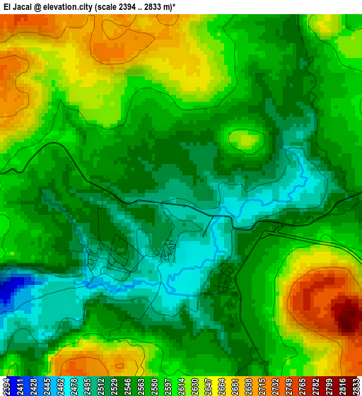
Below is the Elevation map of El Jacal, which displays elevation range with different colors. Scale of the first map is from 2394 to 2833 m (7854 to 9295 ft) with average elevation of 2578 meters (=8458 ft) [note 1]
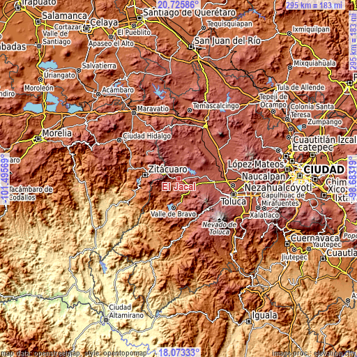
These maps also provides idea of topography and contour of this city, they are displayed at different zoom levels. More info about maps, scale and edge coordinates you can find below images.
| \ | Map #1 | Topo.Map |
| Scale [m] | 2394..2833 m | × |
| Scale [ft] | 7854..9295 ft | × |
| Average | 2578 m = 8458 ft | × |
| Width | 9.22 km = 5.7 mi | 294.9 km = 183.2 mi |
| Height | 9.22 km = 5.7 mi | 295 km = 183.3 mi |
| ↑Max Latitude | 19.446444° | 20.72586° |
| Latitude at center | 19.405° | 19.405° |
| ↓Min Latitude | 19.363546° | 18.07333° |
| ← Min Longitude | -100.133385° | -101.49569° |
| Longitude center | -100.08944° | -100.08944° |
| →Max Longitude | -100.045495° | -98.68319° |
Nearby cities:
Cities around El Jacal sort by population:
• San Felipe Santiago elevation 2511 m
2.4 km,  227°
227°
• El Espinal 2612 m
7.6 km,  23°
23°
• Barrio los Tules 2588 m
3.1 km,  29°
29°
• Loma de Juárez 2672 m
3.4 km,  358°
358°
• Los Berros 2572 m
4.4 km,  100°
100°
• Barrio el Vivero 2579 m
7.8 km,  46°
46°
• San José Villa de Allende 2384 m
7 km,  241°
241°
• San Agustín Berros 2825 m
8.3 km,  91°
91°
• Barrio la Joya 2558 m
2 km,  327°
327°
• San Ildefonso 2348 m
8 km,  219°
219°
• Barrio el Boncho 2631 m
2.9 km,  322°
322°
• Cabecera de Indígenas 2432 m
6.2 km, 233°
Multilingual:
 En español:
El Jacal elevación 2502 m.
 En France:
El Jacal élévation 2502 m.
 Auf Deutsch:
El Jacal höhe über dem Meeresspiegel ist 2502 m.

Sources and notes:
- [note 1] Map square and city borders are not equal. Map elevation data is calculated only from area inside that square.
- [src 1] Elevation data from geonames database provided with same terms of usage.
- [src 2] The elevation map of El Jacal is generated using elevation data from NASA's 3 arcsec (90m) resolution SRTM data.
- [src 3] Base (background) map © OpenStreetMap contributors tiles are generated by Geofabrik and OpenTopoMap.
Copyright & License:
This El Jacal Elevation Map is licensed under CC BY-SA. You may reuse any part from this page, if you give a proper credit by linking to this URL:
 More info on terms of use page.