Tepetzingo elevation
Tepetzingo (State of Mexico, Tenancingo), Mexico elevation is 2089 meters and Tepetzingo elevation in feet is 6854 ft above sea level [src 1]. Tepetzingo is a populated place (feature code) with elevation that is 775 meters (2543 ft) bigger than average city elevation in Mexico.
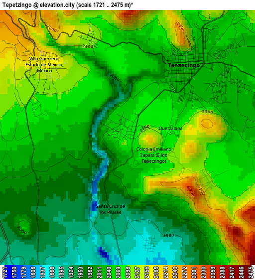
Below is the Elevation map of Tepetzingo, which displays elevation range with different colors. Scale of the first map is from 1721 to 2475 m (5646 to 8120 ft) with average elevation of 2048.8 meters (=6722 ft) [note 1]
These maps also provides idea of topography and contour of this city, they are displayed at different zoom levels. More info about maps, scale and edge coordinates you can find below images.
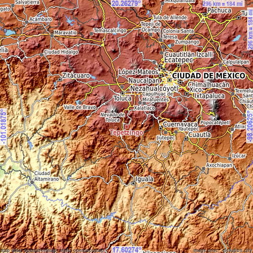
| \ | Map #1 | Topo.Map |
| Scale [m] | 1721..2475 m | × |
| Scale [ft] | 5646..8120 ft | × |
| Average | 2048.8 m = 6722 ft | × |
| Width | 9.24 km = 5.7 mi | 295.8 km = 183.8 mi |
| Height | 9.24 km = 5.7 mi | 295.8 km = 183.8 mi |
| ↑Max Latitude | 18.979621° | 20.26279° |
| Latitude at center | 18.93806° | 18.93806° |
| ↓Min Latitude | 18.896488° | 17.60274° |
| ← Min Longitude | -99.656445° | -101.01875° |
| Longitude center | -99.6125° | -99.6125° |
| →Max Longitude | -99.568555° | -98.20625° |
Nearby cities:
Cities around Tepetzingo sort by population:
• Tenancingo de Degollado elevation 2033 m
3.5 km,  42°
42°
• Villa Guerrero 2170 m
4 km,  312°
312°
• Santa Ana Ixtlahuatzingo (Santa Ana) 2106 m
3.8 km,  342°
342°
• El Salitre 2021 m
2.9 km,  56°
56°
• San Francisco 2097 m
3.9 km,  288°
288°
• La Ciénega 2029 m
3.8 km, 58°
• Acatzingo (Acatzingo de la Piedra) 2149 m
3 km,  122°
122°
• Tepalcatepec 2093 m
1.4 km,  101°
101°
• Ejido de San Mateo Coapexco 2083 m
3.4 km, 290°
• Jesús Carranza (Rancho de Jesús) 2050 m
2.1 km, 292°
• Pueblo Nuevo 2056 m
3.2 km,  69°
69°
• Quetzalapa 2077 m
1.7 km,  80°
80°
Multilingual:
 En español:
Tepetzingo elevación 2089 m.
 En France:
Tepetzingo élévation 2089 m.
 Auf Deutsch:
Tepetzingo höhe über dem Meeresspiegel ist 2089 m.

Sources and notes:
- [note 1] Map square and city borders are not equal. Map elevation data is calculated only from area inside that square.
- [src 1] Elevation data from geonames database provided with same terms of usage.
- [src 2] The elevation map of Tepetzingo is generated using elevation data from NASA's 3 arcsec (90m) resolution SRTM data.
- [src 3] Base (background) map © OpenStreetMap contributors tiles are generated by Geofabrik and OpenTopoMap.
Copyright & License:
This Tepetzingo Elevation Map is licensed under CC BY-SA. You may reuse any part from this page, if you give a proper credit by linking to this URL:
 More info on terms of use page.