Rancho Verde elevation
Rancho Verde (Baja California, Ensenada), Mexico elevation is 84 meters and Rancho Verde elevation in feet is 276 ft above sea level [src 1]. Rancho Verde is a populated place (feature code) with elevation that is 1230 meters (4035 ft) smaller than average city elevation in Mexico.
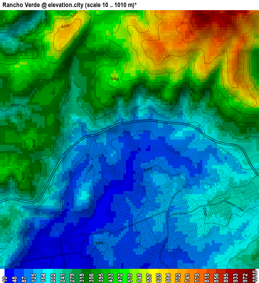
Below is the Elevation map of Rancho Verde, which displays elevation range with different colors. Scale of the first map is from 10 to 1010 m (33 to 3314 ft) with average elevation of 288.2 meters (=946 ft) [note 1]
These maps also provides idea of topography and contour of this city, they are displayed at different zoom levels. More info about maps, scale and edge coordinates you can find below images.
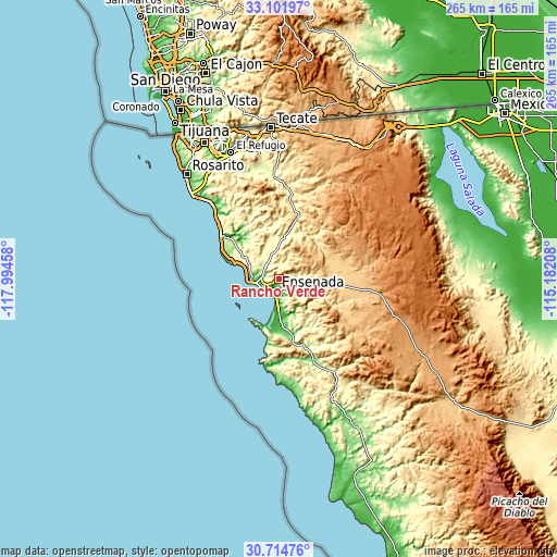
| \ | Map #1 | Topo.Map |
| Scale [m] | 10..1010 m | × |
| Scale [ft] | 33..3314 ft | × |
| Average | 288.2 m = 946 ft | × |
| Width | 8.3 km = 5.2 mi | 265.4 km = 164.9 mi |
| Height | 8.3 km = 5.2 mi | 265.4 km = 164.9 mi |
| ↑Max Latitude | 31.953404° | 33.10197° |
| Latitude at center | 31.91611° | 31.91611° |
| ↓Min Latitude | 31.878801° | 30.71476° |
| ← Min Longitude | -116.632275° | -117.99458° |
| Longitude center | -116.58833° | -116.58833° |
| →Max Longitude | -116.544385° | -115.18208° |
Nearby cities:
Cities around Rancho Verde sort by population:
• Ensenada elevation 29 m
5.1 km,  193°
193°
• Rodolfo Sánchez Taboada 34 m
21.8 km,  175°
175°
• El Sauzal de Rodríguez 20 m
10.2 km,  255°
255°
• Benito García (El Zorrillo) 129 m
28.2 km,  165°
165°
• Primo Tapia 62 m
45.8 km,  317°
317°
• Francisco Zarco 343 m
20.4 km,  5°
5°
• Ciudad Morelos 172 m
62 km, 320°
• Salvador Rosas Magallón 234 m
4.2 km,  113°
113°
• El Porvenir 317 m
18.1 km,  349°
349°
• Colonia Gómez Morín 279 m
5.7 km,  132°
132°
• Santa Anita 4 m
33.5 km,  307°
307°
• Fraccionamiento del Valle 703 m
30.9 km,  90°
90°
Multilingual:
 En español:
Rancho Verde elevación 84 m.
 En France:
Rancho Verde élévation 84 m.
 Auf Deutsch:
Rancho Verde höhe über dem Meeresspiegel ist 84 m.

Sources and notes:
- [note 1] Map square and city borders are not equal. Map elevation data is calculated only from area inside that square.
- [src 1] Elevation data from geonames database provided with same terms of usage.
- [src 2] The elevation map of Rancho Verde is generated using elevation data from NASA's 3 arcsec (90m) resolution SRTM data.
- [src 3] Base (background) map © OpenStreetMap contributors tiles are generated by Geofabrik and OpenTopoMap.
Copyright & License:
This Rancho Verde Elevation Map is licensed under CC BY-SA. You may reuse any part from this page, if you give a proper credit by linking to this URL:
 More info on terms of use page.