Melchor Ocampo elevation
Melchor Ocampo (Tabasco, Cárdenas), Mexico elevation is 30 meters and Melchor Ocampo elevation in feet is 98 ft above sea level [src 1]. Melchor Ocampo is a populated place (feature code) with elevation that is 1284 meters (4213 ft) smaller than average city elevation in Mexico.
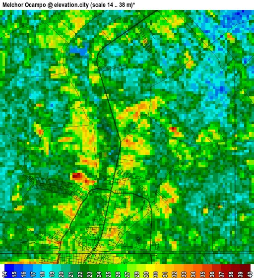
Below is the Elevation map of Melchor Ocampo, which displays elevation range with different colors. Scale of the first map is from 14 to 38 m (46 to 125 ft) with average elevation of 23 meters (=75 ft) [note 1]
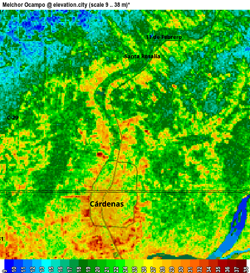
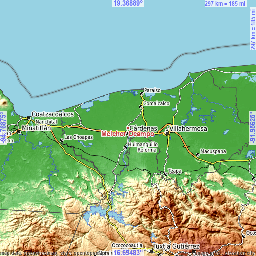
These maps also provides idea of topography and contour of this city, they are displayed at different zoom levels. More info about maps, scale and edge coordinates you can find below images.
| \ | Map #1 | Map #2 | Topo.Map |
| Scale [m] | 14..38 m | 9..38 m | × |
| Scale [ft] | 46..125 ft | 30..125 ft | × |
| Average | 23 m = 75 ft | 21.9 m = 72 ft | × |
| Width | 9.29 km = 5.8 mi | 18.58 km = 11.5 mi | 297.3 km = 184.7 mi |
| Height | 9.29 km = 5.8 mi | 18.58 km = 11.5 mi | 297.3 km = 184.7 mi |
| ↑Max Latitude | 18.078721° | 18.120492° | 19.36889° |
| Latitude at center | 18.03694° | 18.03694° | 18.03694° |
| ↓Min Latitude | 17.995149° | 17.953349° | 16.69483° |
| ← Min Longitude | -93.406445° | -93.450391° | -94.76875° |
| Longitude center | -93.3625° | -93.3625° | -93.3625° |
| →Max Longitude | -93.318555° | -93.274609° | -91.95625° |
Nearby cities:
Cities around Melchor Ocampo sort by population:
• Cárdenas elevation 26 m
4.2 km,  199°
199°
• Santa Rosalía 22 m
5.8 km,  4°
4°
• Cucuyulapa Primera Sección 21 m
12.4 km,  114°
114°
• El Tular 18 m
13.3 km,  11°
11°
• Arroyo Hondo Abejonal 26 m
8.3 km,  217°
217°
• Habanero 1ra. Sección (Venustiano Carranza) 25 m
8.5 km,  154°
154°
• La Península 28 m
10.4 km,  179°
179°
• Benito Juárez (La Playita) 31 m
11.6 km, 181°
• Miguel Hidalgo 2da. Sección B (La Natividad) 26 m
4.8 km,  15°
15°
• Amado Gómez 18 m
12.2 km, 3°
• Arena 6ta. Sección (La Bolsa) 13 m
14.4 km,  345°
345°
• Río Seco 2da. Sección (Santiaguito) 18 m
14.5 km,  39°
39°
Multilingual:
 En español:
Melchor Ocampo elevación 30 m.
 En France:
Melchor Ocampo élévation 30 m.
 Auf Deutsch:
Melchor Ocampo höhe über dem Meeresspiegel ist 30 m.

Sources and notes:
- [note 1] Map square and city borders are not equal. Map elevation data is calculated only from area inside that square.
- [src 1] Elevation data from geonames database provided with same terms of usage.
- [src 2] The elevation map of Melchor Ocampo is generated using elevation data from NASA's 3 arcsec (90m) resolution SRTM data.
- [src 3] Base (background) map © OpenStreetMap contributors tiles are generated by Geofabrik and OpenTopoMap.
Copyright & License:
This Melchor Ocampo Elevation Map is licensed under CC BY-SA. You may reuse any part from this page, if you give a proper credit by linking to this URL:
 More info on terms of use page.