Ichán elevation
Ichán (Michoacán, Chilchota), Mexico elevation is 1902 meters and Ichán elevation in feet is 6240 ft above sea level [src 1]. Ichán is a populated place (feature code) with elevation that is 588 meters (1929 ft) bigger than average city elevation in Mexico.
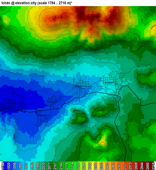
Below is the Elevation map of Ichán, which displays elevation range with different colors. Scale of the first map is from 1784 to 2716 m (5853 to 8911 ft) with average elevation of 2075.2 meters (=6808 ft) [note 1]
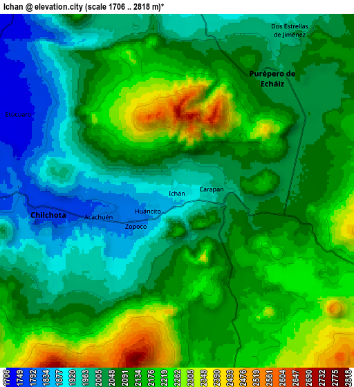
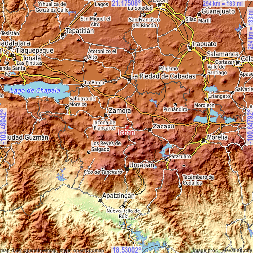
These maps also provides idea of topography and contour of this city, they are displayed at different zoom levels. More info about maps, scale and edge coordinates you can find below images.
| \ | Map #1 | Map #2 | Topo.Map |
| Scale [m] | 1784..2716 m | 1706..2818 m | × |
| Scale [ft] | 5853..8911 ft | 5597..9245 ft | × |
| Average | 2075.2 m = 6808 ft | 2084.6 m = 6839 ft | × |
| Width | 9.19 km = 5.7 mi | 18.38 km = 11.4 mi | 294.1 km = 182.7 mi |
| Height | 9.19 km = 5.7 mi | 18.38 km = 11.4 mi | 294.1 km = 182.7 mi |
| ↑Max Latitude | 19.899387° | 19.940703° | 21.17508° |
| Latitude at center | 19.85806° | 19.85806° | 19.85806° |
| ↓Min Latitude | 19.816722° | 19.775374° | 18.53002° |
| ← Min Longitude | -102.098115° | -102.142061° | -103.46042° |
| Longitude center | -102.05417° | -102.05417° | -102.05417° |
| →Max Longitude | -102.010225° | -101.966279° | -100.64792° |
Nearby cities:
Cities around Ichán sort by population:
• Purépero de Echáiz elevation 2022 m
7.7 km,  40°
40°
• Chilchota 1778 m
6.7 km,  258°
258°
• Carapán 1964 m
1.9 km,  83°
83°
• Huancito 1839 m
1.8 km,  234°
234°
• Zopoco 1835 m
2.9 km, 227°
• Acachuén 1800 m
4.2 km,  253°
253°
• Tacuro (Santa María Tacuro) 1898 m
0.4 km,  109°
109°
• Tanaquillo 1789 m
4.8 km, 253°
• Urén 1784 m
5.5 km, 255°
• Santo Tomás 1814 m
3.6 km, 246°
• Los Nogales 1736 m
10.7 km,  269°
269°
• Etúcuaro 1731 m
8.8 km,  296°
296°
Multilingual:
 En español:
Ichán elevación 1902 m.
 En France:
Ichán élévation 1902 m.


Sources and notes:
- [note 1] Map square and city borders are not equal. Map elevation data is calculated only from area inside that square.
- [src 1] Elevation data from geonames database provided with same terms of usage.
- [src 2] The elevation map of Ichán is generated using elevation data from NASA's 3 arcsec (90m) resolution SRTM data.
- [src 3] Base (background) map © OpenStreetMap contributors tiles are generated by Geofabrik and OpenTopoMap.
Copyright & License:
This Ichán Elevation Map is licensed under CC BY-SA. You may reuse any part from this page, if you give a proper credit by linking to this URL:
 More info on terms of use page.