General Lázaro Cárdenas (El Colorado) elevation
General Lázaro Cárdenas (El Colorado) (Querétaro, El Marqués), Mexico elevation is 1914 meters and General Lázaro Cárdenas (El Colorado) elevation in feet is 6280 ft above sea level [src 1]. General Lázaro Cárdenas (El Colorado) is a populated place (feature code) with elevation that is 600 meters (1969 ft) bigger than average city elevation in Mexico.
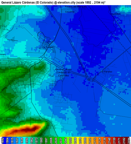
Below is the Elevation map of General Lázaro Cárdenas (El Colorado), which displays elevation range with different colors. Scale of the first map is from 1892 to 2194 m (6207 to 7198 ft) with average elevation of 1933.1 meters (=6342 ft) [note 1]
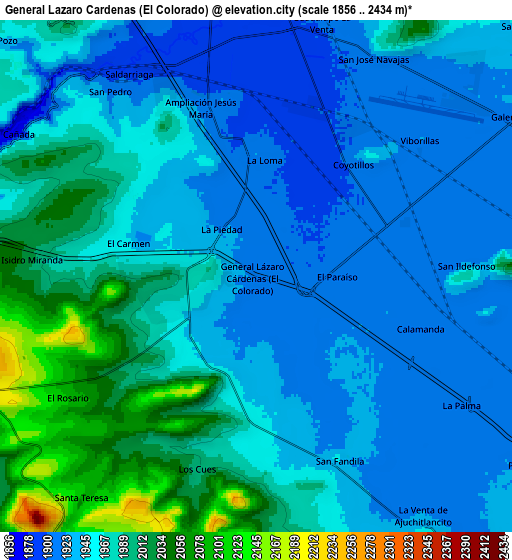
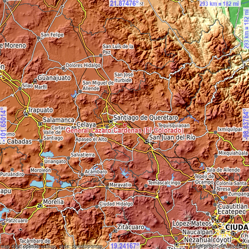
These maps also provides idea of topography and contour of this city, they are displayed at different zoom levels. More info about maps, scale and edge coordinates you can find below images.
| \ | Map #1 | Map #2 | Topo.Map |
| Scale [m] | 1892..2194 m | 1856..2434 m | × |
| Scale [ft] | 6207..7198 ft | 6089..7986 ft | × |
| Average | 1933.1 m = 6342 ft | 1961.2 m = 6434 ft | × |
| Width | 9.15 km = 5.7 mi | 18.3 km = 11.4 mi | 292.8 km = 181.9 mi |
| Height | 9.15 km = 5.7 mi | 18.3 km = 11.4 mi | 292.8 km = 181.9 mi |
| ↑Max Latitude | 20.60503° | 20.646158° | 21.87476° |
| Latitude at center | 20.56389° | 20.56389° | 20.56389° |
| ↓Min Latitude | 20.522739° | 20.481578° | 19.24167° |
| ← Min Longitude | -100.287835° | -100.331781° | -101.65014° |
| Longitude center | -100.24389° | -100.24389° | -100.24389° |
| →Max Longitude | -100.199945° | -100.155999° | -98.83764° |
Nearby cities:
Cities around General Lázaro Cárdenas (El Colorado) sort by population:
• El Colorado elevation 1913 m
0.3 km,  211°
211°
• La Piedad 1922 m
2.1 km,  323°
323°
• Jesús María 1900 m
6.7 km,  348°
348°
• Palo Alto 1915 m
3.5 km,  137°
137°
• Agua Azul 1948 m
5.9 km,  43°
43°
• Coyotillos 1912 m
5.4 km, 42°
• Calamanda 1915 m
6.3 km,  107°
107°
• Los Cues 1999 m
7.2 km,  197°
197°
• Paseos del Marqués 1910 m
4.5 km,  4°
4°
• La Loma 1913 m
4 km,  7°
7°
• El Paraíso 1913 m
2.9 km,  89°
89°
• El Carmen 1946 m
4.7 km,  284°
284°
Multilingual:
 En español:
General Lázaro Cárdenas (El Colorado) elevación 1914 m.
 En France:
General Lázaro Cárdenas (El Colorado) élévation 1914 m.
 Auf Deutsch:
General Lázaro Cárdenas (El Colorado) höhe über dem Meeresspiegel ist 1914 m.
 На русском:
General Lázaro Cárdenas (El Colorado) высота над уровнем моря 1914 м
Sources and notes:
- [note 1] Map square and city borders are not equal. Map elevation data is calculated only from area inside that square.
- [src 1] Elevation data from geonames database provided with same terms of usage.
- [src 2] The elevation map of General Lázaro Cárdenas (El Colorado) is generated using elevation data from NASA's 3 arcsec (90m) resolution SRTM data.
- [src 3] Base (background) map © OpenStreetMap contributors tiles are generated by Geofabrik and OpenTopoMap.
Copyright & License:
This General Lázaro Cárdenas (El Colorado) Elevation Map is licensed under CC BY-SA. You may reuse any part from this page, if you give a proper credit by linking to this URL:
 More info on terms of use page.