San Felipe elevation
San Felipe (Durango, Gómez Palacio), Mexico elevation is 1117 meters and San Felipe elevation in feet is 3665 ft above sea level [src 1]. San Felipe is a populated place (feature code) with elevation that is 197 meters (646 ft) smaller than average city elevation in Mexico.
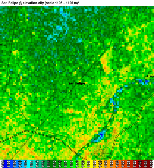
Below is the Elevation map of San Felipe, which displays elevation range with different colors. Scale of the first map is from 1106 to 1126 m (3629 to 3694 ft) with average elevation of 1116.7 meters (=3664 ft) [note 1]
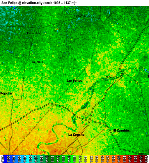
These maps also provides idea of topography and contour of this city, they are displayed at different zoom levels. More info about maps, scale and edge coordinates you can find below images.
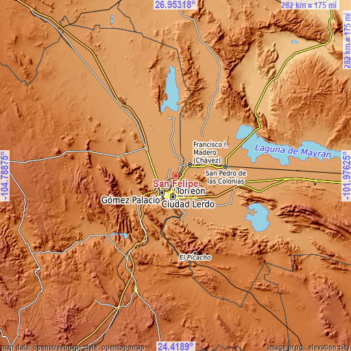
| \ | Map #1 | Map #2 | Topo.Map |
| Scale [m] | 1106..1126 m | 1098..1137 m | × |
| Scale [ft] | 3629..3694 ft | 3602..3730 ft | × |
| Average | 1116.7 m = 3664 ft | 1116.2 m = 3662 ft | × |
| Width | 8.81 km = 5.5 mi | 17.61 km = 10.9 mi | 281.8 km = 175.1 mi |
| Height | 8.81 km = 5.5 mi | 17.61 km = 10.9 mi | 281.8 km = 175.1 mi |
| ↑Max Latitude | 25.732374° | 25.771955° | 26.95318° |
| Latitude at center | 25.69278° | 25.69278° | 25.69278° |
| ↓Min Latitude | 25.653173° | 25.613553° | 24.4189° |
| ← Min Longitude | -103.426445° | -103.470391° | -104.78875° |
| Longitude center | -103.3825° | -103.3825° | -103.3825° |
| →Max Longitude | -103.338555° | -103.294609° | -101.97625° |
Nearby cities:
Cities around San Felipe sort by population:
• La Concha elevation 1124 m
6.4 km,  178°
178°
• Hormiguero 1118 m
4.3 km,  103°
103°
• San José de Viñedo 1123 m
5.3 km,  202°
202°
• Purísima 1118 m
6.2 km, 102°
• Albia 1120 m
3.6 km,  146°
146°
• La Flor 1120 m
1.9 km,  131°
131°
• Santa Cruz Luján 1118 m
4.3 km,  33°
33°
• Villa Gregorio García 1114 m
7.3 km,  24°
24°
• Veinte de Noviembre 1118 m
5.7 km,  68°
68°
• Escuadrón Doscientos Uno 1119 m
4 km,  120°
120°
• Maravillas 1117 m
5.6 km, 132°
• El Cuije 1120 m
4.2 km,  84°
84°
Multilingual:
 En español:
San Felipe elevación 1117 m.
 En France:
San Felipe élévation 1117 m.
 Auf Deutsch:
San Felipe höhe über dem Meeresspiegel ist 1117 m.

Sources and notes:
- [note 1] Map square and city borders are not equal. Map elevation data is calculated only from area inside that square.
- [src 1] Elevation data from geonames database provided with same terms of usage.
- [src 2] The elevation map of San Felipe is generated using elevation data from NASA's 3 arcsec (90m) resolution SRTM data.
- [src 3] Base (background) map © OpenStreetMap contributors tiles are generated by Geofabrik and OpenTopoMap.
Copyright & License:
This San Felipe Elevation Map is licensed under CC BY-SA. You may reuse any part from this page, if you give a proper credit by linking to this URL:
 More info on terms of use page.