Unidad Acaquilpan elevation
Unidad Acaquilpan (State of Mexico, La Paz), Mexico elevation is 2323 meters and Unidad Acaquilpan elevation in feet is 7621 ft above sea level [src 1]. Unidad Acaquilpan is a populated place (feature code) with elevation that is 1009 meters (3310 ft) bigger than average city elevation in Mexico.
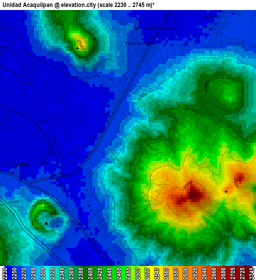
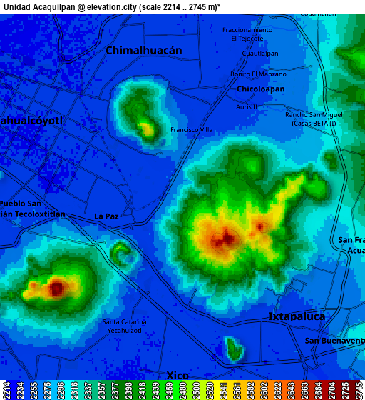
Below is the Elevation map of Unidad Acaquilpan, which displays elevation range with different colors. Scale of the first map is from 2230 to 2745 m (7316 to 9006 ft) with average elevation of 2337.2 meters (=7668 ft) [note 1]
These maps also provides idea of topography and contour of this city, they are displayed at different zoom levels. More info about maps, scale and edge coordinates you can find below images.
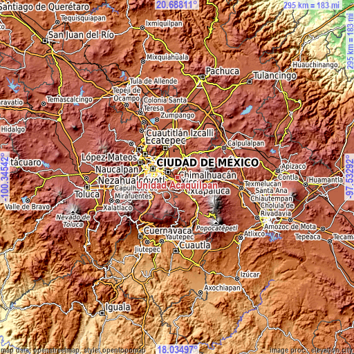
| \ | Map #1 | Map #2 | Topo.Map |
| Scale [m] | 2230..2745 m | 2214..2745 m | × |
| Scale [ft] | 7316..9006 ft | 7264..9006 ft | × |
| Average | 2337.2 m = 7668 ft | 2292.7 m = 7522 ft | × |
| Width | 9.22 km = 5.7 mi | 18.44 km = 11.5 mi | 295 km = 183.3 mi |
| Height | 9.22 km = 5.7 mi | 18.44 km = 11.5 mi | 295 km = 183.3 mi |
| ↑Max Latitude | 19.408393° | 19.449836° | 20.68811° |
| Latitude at center | 19.36694° | 19.36694° | 19.36694° |
| ↓Min Latitude | 19.325476° | 19.284002° | 18.03497° |
| ← Min Longitude | -98.983115° | -99.027061° | -100.34542° |
| Longitude center | -98.93917° | -98.93917° | -98.93917° |
| →Max Longitude | -98.895225° | -98.851279° | -97.53292° |
Nearby cities:
Cities around Unidad Acaquilpan sort by population:
• San Isidro elevation 2259 m
3.3 km,  201°
201°
• Magdalena Atlicpac 2247 m
1.1 km,  282°
282°
• San Sebastián Chimalpa 2241 m
2.3 km,  314°
314°
• Lomas de San Sebastián 2308 m
1.8 km,  20°
20°
• Profesor Carlos Hank González 2283 m
0.6 km,  2°
2°
• El Pino 2314 m
2 km,  209°
209°
• San José las Palmas 2379 m
0.6 km,  86°
86°
• Tecamachalco 2243 m
2.3 km,  249°
249°
• Arenal 2256 m
1.6 km,  346°
346°
• Lomas de Altavista 2297 m
0.8 km,  223°
223°
• Bosques de la Magdalena 2304 m
1.3 km, 220°
• Techachaltitla 2319 m
0.3 km, 214°
Multilingual:
 En español:
Unidad Acaquilpan elevación 2323 m.
 En France:
Unidad Acaquilpan élévation 2323 m.
 Auf Deutsch:
Unidad Acaquilpan höhe über dem Meeresspiegel ist 2323 m.
 На русском:
Unidad Acaquilpan высота над уровнем моря 2323 м
Sources and notes:
- [note 1] Map square and city borders are not equal. Map elevation data is calculated only from area inside that square.
- [src 1] Elevation data from geonames database provided with same terms of usage.
- [src 2] The elevation map of Unidad Acaquilpan is generated using elevation data from NASA's 3 arcsec (90m) resolution SRTM data.
- [src 3] Base (background) map © OpenStreetMap contributors tiles are generated by Geofabrik and OpenTopoMap.
Copyright & License:
This Unidad Acaquilpan Elevation Map is licensed under CC BY-SA. You may reuse any part from this page, if you give a proper credit by linking to this URL:
 More info on terms of use page.