Los Tuzos elevation
Los Tuzos (Hidalgo, Mineral de la Reforma), Mexico elevation is 2347 meters and Los Tuzos elevation in feet is 7700 ft above sea level [src 1]. Los Tuzos is a populated place (feature code) with elevation that is 1033 meters (3389 ft) bigger than average city elevation in Mexico.
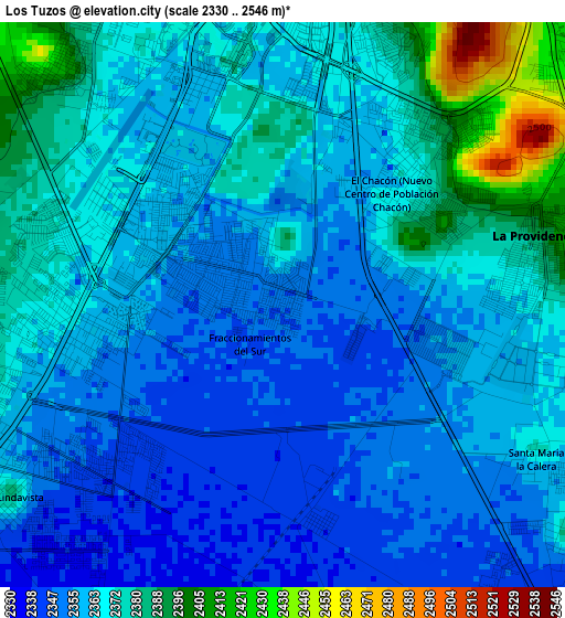
Below is the Elevation map of Los Tuzos, which displays elevation range with different colors. Scale of the first map is from 2330 to 2546 m (7644 to 8353 ft) with average elevation of 2365.2 meters (=7760 ft) [note 1]
These maps also provides idea of topography and contour of this city, they are displayed at different zoom levels. More info about maps, scale and edge coordinates you can find below images.
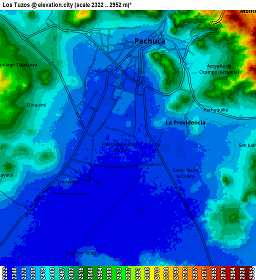
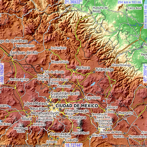
| \ | Map #1 | Map #2 | Topo.Map |
| Scale [m] | 2330..2546 m | 2322..2952 m | × |
| Scale [ft] | 7644..8353 ft | 7618..9685 ft | × |
| Average | 2365.2 m = 7760 ft | 2416.3 m = 7927 ft | × |
| Width | 9.18 km = 5.7 mi | 18.36 km = 11.4 mi | 293.7 km = 182.5 mi |
| Height | 9.18 km = 5.7 mi | 18.36 km = 11.4 mi | 293.8 km = 182.6 mi |
| ↑Max Latitude | 20.095165° | 20.13643° | 21.36922° |
| Latitude at center | 20.05389° | 20.05389° | 20.05389° |
| ↓Min Latitude | 20.012604° | 19.971306° | 18.72744° |
| ← Min Longitude | -98.800335° | -98.844281° | -100.16264° |
| Longitude center | -98.75639° | -98.75639° | -98.75639° |
| →Max Longitude | -98.712445° | -98.668499° | -97.35014° |
Nearby cities:
Cities around Los Tuzos sort by population:
• El Saucillo (Fraccionamiento) elevation 2394 m
3 km,  58°
58°
• Forjadores de Pachuca 2351 m
0.7 km,  279°
279°
• La Colonia 2346 m
1.5 km,  273°
273°
• El Saucillo 2375 m
3.3 km,  37°
37°
• Tulipanes 2352 m
1.3 km,  302°
302°
• Magisterio Digno 2350 m
1.3 km, 284°
• Cipreses 2353 m
1.3 km, 295°
• Nuevo Centro de Población Agrícola el Chacón 2364 m
2.5 km, 44°
• El Venado 2359 m
1.1 km,  338°
338°
• El Roble 2355 m
0.5 km, 336°
• Rinconadas del Venado I 2354 m
1.3 km,  326°
326°
• Rinconadas de San Francisco 2360 m
1.8 km,  318°
318°
Multilingual:
 En español:
Los Tuzos elevación 2347 m.
 En France:
Los Tuzos élévation 2347 m.
 Auf Deutsch:
Los Tuzos höhe über dem Meeresspiegel ist 2347 m.

Sources and notes:
- [note 1] Map square and city borders are not equal. Map elevation data is calculated only from area inside that square.
- [src 1] Elevation data from geonames database provided with same terms of usage.
- [src 2] The elevation map of Los Tuzos is generated using elevation data from NASA's 3 arcsec (90m) resolution SRTM data.
- [src 3] Base (background) map © OpenStreetMap contributors tiles are generated by Geofabrik and OpenTopoMap.
Copyright & License:
This Los Tuzos Elevation Map is licensed under CC BY-SA. You may reuse any part from this page, if you give a proper credit by linking to this URL:
 More info on terms of use page.