La Pastoría elevation
La Pastoría (State of Mexico, Atenco), Mexico elevation is 2250 meters and La Pastoría elevation in feet is 7382 ft above sea level [src 1]. La Pastoría is a populated place (feature code) with elevation that is 936 meters (3071 ft) bigger than average city elevation in Mexico.
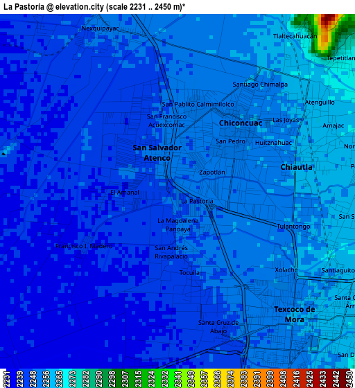
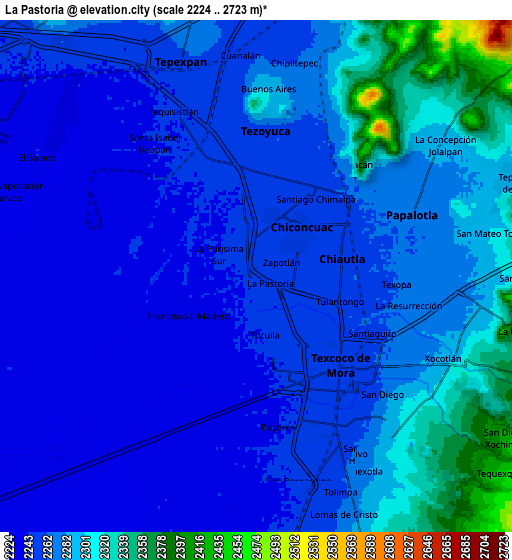
Below is the Elevation map of La Pastoría, which displays elevation range with different colors. Scale of the first map is from 2231 to 2450 m (7320 to 8038 ft) with average elevation of 2248.9 meters (=7378 ft) [note 1]
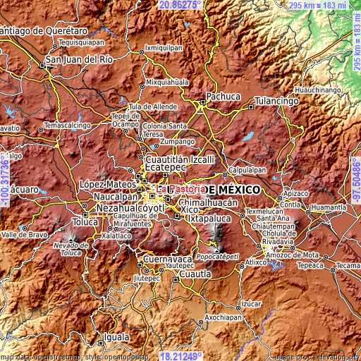
These maps also provides idea of topography and contour of this city, they are displayed at different zoom levels. More info about maps, scale and edge coordinates you can find below images.
| \ | Map #1 | Map #2 | Topo.Map |
| Scale [m] | 2231..2450 m | 2224..2723 m | × |
| Scale [ft] | 7320..8038 ft | 7297..8934 ft | × |
| Average | 2248.9 m = 7378 ft | 2271.2 m = 7451 ft | × |
| Width | 9.21 km = 5.7 mi | 18.42 km = 11.4 mi | 294.7 km = 183.1 mi |
| Height | 9.21 km = 5.7 mi | 18.42 km = 11.4 mi | 294.7 km = 183.1 mi |
| ↑Max Latitude | 19.584468° | 19.625866° | 20.86275° |
| Latitude at center | 19.54306° | 19.54306° | 19.54306° |
| ↓Min Latitude | 19.501641° | 19.460211° | 18.21249° |
| ← Min Longitude | -98.955055° | -98.999001° | -100.31736° |
| Longitude center | -98.91111° | -98.91111° | -98.91111° |
| →Max Longitude | -98.867165° | -98.823219° | -97.50486° |
Nearby cities:
Cities around La Pastoría sort by population:
• Texcoco de Mora elevation 2257 m
4.5 km,  139°
139°
• Chiconcuac 2254 m
2.2 km,  35°
35°
• San Salvador Atenco 2250 m
1.2 km,  320°
320°
• Tulantongo 2259 m
4 km,  108°
108°
• Chiautla 2258 m
3.1 km,  77°
77°
• San Cristóbal Nexquipayac 2250 m
4.6 km,  333°
333°
• Santiago Chimalpa (Chimalpa) 2255 m
3.5 km, 35°
• Zapotlán 2252 m
0.9 km,  64°
64°
• Colonia Lázaro Cárdenas 2239 m
3.5 km,  195°
195°
• Ampliación Tezoyuca 2251 m
4.3 km,  346°
346°
• Ejido San Cristóbal 2254 m
1.8 km,  92°
92°
• Atenguillo 2262 m
4.3 km, 57°
Multilingual:
 En español:
La Pastoría elevación 2250 m.
 En France:
La Pastoría élévation 2250 m.
 Auf Deutsch:
La Pastoría höhe über dem Meeresspiegel ist 2250 m.

Sources and notes:
- [note 1] Map square and city borders are not equal. Map elevation data is calculated only from area inside that square.
- [src 1] Elevation data from geonames database provided with same terms of usage.
- [src 2] The elevation map of La Pastoría is generated using elevation data from NASA's 3 arcsec (90m) resolution SRTM data.
- [src 3] Base (background) map © OpenStreetMap contributors tiles are generated by Geofabrik and OpenTopoMap.
Copyright & License:
This La Pastoría Elevation Map is licensed under CC BY-SA. You may reuse any part from this page, if you give a proper credit by linking to this URL:
 More info on terms of use page.