Tecámac de Felipe Villanueva elevation
Tecámac de Felipe Villanueva (State of Mexico, Tecámac), Mexico elevation is 2274 meters and Tecámac de Felipe Villanueva elevation in feet is 7461 ft above sea level [src 1]. Tecámac de Felipe Villanueva is a populated place (feature code) with elevation that is 960 meters (3150 ft) bigger than average city elevation in Mexico.
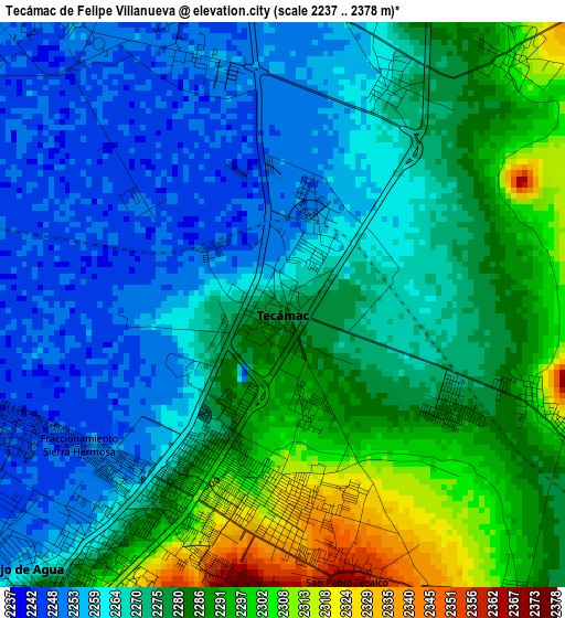
Below is the Elevation map of Tecámac de Felipe Villanueva, which displays elevation range with different colors. Scale of the first map is from 2237 to 2378 m (7339 to 7802 ft) with average elevation of 2274 meters (=7461 ft) [note 1]
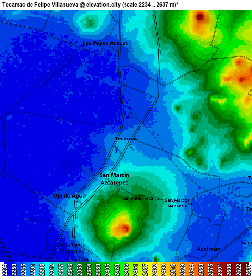
These maps also provides idea of topography and contour of this city, they are displayed at different zoom levels. More info about maps, scale and edge coordinates you can find below images.
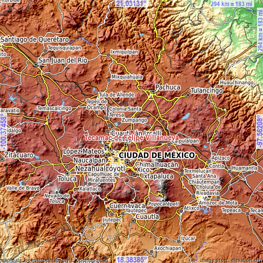
| \ | Map #1 | Map #2 | Topo.Map |
| Scale [m] | 2237..2378 m | 2234..2637 m | × |
| Scale [ft] | 7339..7802 ft | 7329..8652 ft | × |
| Average | 2274 m = 7461 ft | 2297.5 m = 7538 ft | × |
| Width | 9.2 km = 5.7 mi | 18.4 km = 11.4 mi | 294.4 km = 182.9 mi |
| Height | 9.2 km = 5.7 mi | 18.4 km = 11.4 mi | 294.4 km = 182.9 mi |
| ↑Max Latitude | 19.754424° | 19.795778° | 21.03131° |
| Latitude at center | 19.71306° | 19.71306° | 19.71306° |
| ↓Min Latitude | 19.671685° | 19.630299° | 18.38385° |
| ← Min Longitude | -99.012275° | -99.056221° | -100.37458° |
| Longitude center | -98.96833° | -98.96833° | -98.96833° |
| →Max Longitude | -98.924385° | -98.880439° | -97.56208° |
Nearby cities:
Cities around Tecámac de Felipe Villanueva sort by population:
• Ojo de Agua elevation 2250 m
5.7 km,  230°
230°
• San Martín Azcatepec 2308 m
3 km,  189°
189°
• Reyes Acozac 2259 m
7.1 km,  349°
349°
• Santa María Ajoloapan 2283 m
5.7 km,  9°
9°
• Tecámac 2279 m
0.1 km,  252°
252°
• San Pablo Tecalco 2362 m
4.6 km,  166°
166°
• San Marcos Nepantla 2292 m
6.2 km,  141°
141°
• Sanata Lucía 2251 m
4.1 km,  341°
341°
• Prados de San Juan 2385 m
8.2 km, 185°
• Santiago Zacualuca 2310 m
4.3 km,  108°
108°
• San Miguel Atlamajac 2305 m
5.4 km,  42°
42°
• Fraccionamiento Hacienda del Bosque 2249 m
1.5 km,  358°
358°
Multilingual:
 En español:
Tecámac de Felipe Villanueva elevación 2274 m.
 En France:
Tecámac de Felipe Villanueva élévation 2274 m.
 Auf Deutsch:
Tecámac de Felipe Villanueva höhe über dem Meeresspiegel ist 2274 m.
 На русском:
Tecámac de Felipe Villanueva высота над уровнем моря 2274 м
Sources and notes:
- [note 1] Map square and city borders are not equal. Map elevation data is calculated only from area inside that square.
- [src 1] Elevation data from geonames database provided with same terms of usage.
- [src 2] The elevation map of Tecámac de Felipe Villanueva is generated using elevation data from NASA's 3 arcsec (90m) resolution SRTM data.
- [src 3] Base (background) map © OpenStreetMap contributors tiles are generated by Geofabrik and OpenTopoMap.
Copyright & License:
This Tecámac de Felipe Villanueva Elevation Map is licensed under CC BY-SA. You may reuse any part from this page, if you give a proper credit by linking to this URL:
 More info on terms of use page.