Santa Teresa elevation
Santa Teresa (State of Mexico, Huehuetoca), Mexico elevation is 2286 meters and Santa Teresa elevation in feet is 7500 ft above sea level [src 1]. Santa Teresa is a populated place (feature code) with elevation that is 972 meters (3189 ft) bigger than average city elevation in Mexico.
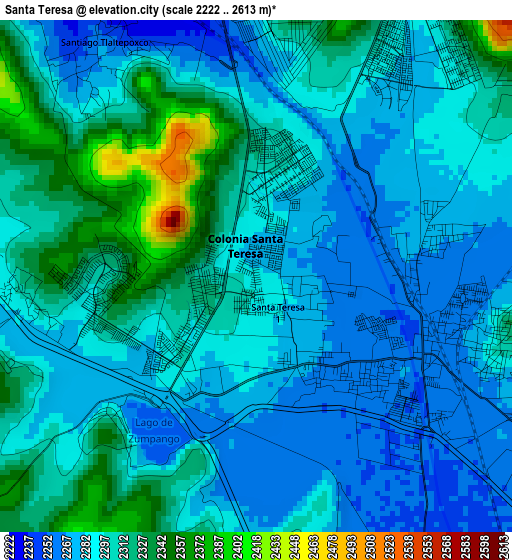
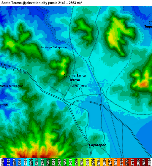
Below is the Elevation map of Santa Teresa, which displays elevation range with different colors. Scale of the first map is from 2222 to 2613 m (7290 to 8573 ft) with average elevation of 2297.1 meters (=7536 ft) [note 1]
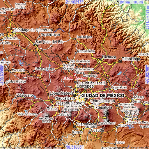
These maps also provides idea of topography and contour of this city, they are displayed at different zoom levels. More info about maps, scale and edge coordinates you can find below images.
| \ | Map #1 | Map #2 | Topo.Map |
| Scale [m] | 2222..2613 m | 2149..2863 m | × |
| Scale [ft] | 7290..8573 ft | 7051..9393 ft | × |
| Average | 2297.1 m = 7536 ft | 2318.2 m = 7606 ft | × |
| Width | 9.19 km = 5.7 mi | 18.38 km = 11.4 mi | 294.1 km = 182.7 mi |
| Height | 9.19 km = 5.7 mi | 18.38 km = 11.4 mi | 294.1 km = 182.7 mi |
| ↑Max Latitude | 19.88633° | 19.92765° | 21.16213° |
| Latitude at center | 19.845° | 19.845° | 19.845° |
| ↓Min Latitude | 19.803659° | 19.762307° | 18.51685° |
| ← Min Longitude | -99.277275° | -99.321221° | -100.63958° |
| Longitude center | -99.23333° | -99.23333° | -99.23333° |
| →Max Longitude | -99.189385° | -99.145439° | -97.82708° |
Nearby cities:
Cities around Santa Teresa sort by population:
• Huehuetoca elevation 2261 m
3.6 km,  121°
121°
• Ex-hacienda de Xalpa 2275 m
5.9 km, 116°
• San Bartolo 2307 m
4.5 km,  107°
107°
• Salitrillo 2259 m
2.5 km,  133°
133°
• San Pedro Xalpa 2292 m
5.5 km, 111°
• Villa URBI del Rey 2352 m
2.5 km,  260°
260°
• Unidad San Miguel Jagüeyes 2389 m
6.3 km,  247°
247°
• Jorobas 2270 m
2.8 km,  213°
213°
• Santiago Tlaltepoxco 2261 m
5.1 km,  326°
326°
• Casa Nueva 2256 m
2.8 km, 117°
• Paseos de la Pradera 2264 m
5.2 km,  354°
354°
• Praderas del Potrero 2319 m
4.4 km,  4°
4°
Multilingual:
 En español:
Santa Teresa elevación 2286 m.
 En France:
Santa Teresa élévation 2286 m.
 Auf Deutsch:
Santa Teresa höhe über dem Meeresspiegel ist 2286 m.

Sources and notes:
- [note 1] Map square and city borders are not equal. Map elevation data is calculated only from area inside that square.
- [src 1] Elevation data from geonames database provided with same terms of usage.
- [src 2] The elevation map of Santa Teresa is generated using elevation data from NASA's 3 arcsec (90m) resolution SRTM data.
- [src 3] Base (background) map © OpenStreetMap contributors tiles are generated by Geofabrik and OpenTopoMap.
Copyright & License:
This Santa Teresa Elevation Map is licensed under CC BY-SA. You may reuse any part from this page, if you give a proper credit by linking to this URL:
 More info on terms of use page.