Buenavista elevation
Buenavista (Morelos), Mexico elevation is 2662 meters and Buenavista elevation in feet is 8734 ft above sea level [src 1]. Buenavista is a populated place (feature code) with elevation that is 1348 meters (4423 ft) bigger than average city elevation in Mexico.
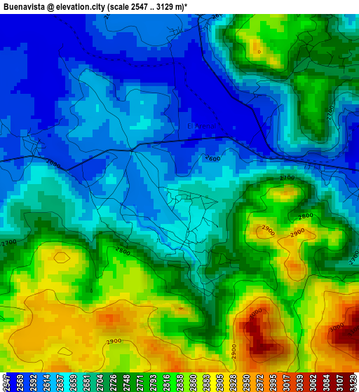
Below is the Elevation map of Buenavista, which displays elevation range with different colors. Scale of the first map is from 2547 to 3129 m (8356 to 10266 ft) with average elevation of 2725.6 meters (=8942 ft) [note 1]
These maps also provides idea of topography and contour of this city, they are displayed at different zoom levels. More info about maps, scale and edge coordinates you can find below images.
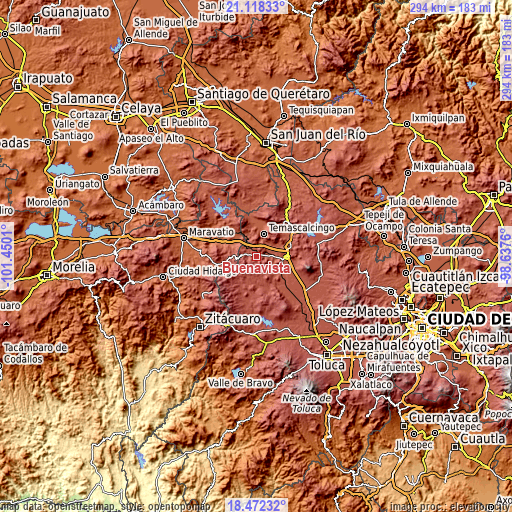
| \ | Map #1 | Topo.Map |
| Scale [m] | 2547..3129 m | × |
| Scale [ft] | 8356..10266 ft | × |
| Average | 2725.6 m = 8942 ft | × |
| Width | 9.19 km = 5.7 mi | 294.2 km = 182.8 mi |
| Height | 9.19 km = 5.7 mi | 294.2 km = 182.8 mi |
| ↑Max Latitude | 19.842162° | 21.11833° |
| Latitude at center | 19.80082° | 19.80082° |
| ↓Min Latitude | 19.759468° | 18.47232° |
| ← Min Longitude | -100.087795° | -101.4501° |
| Longitude center | -100.04385° | -100.04385° |
| →Max Longitude | -99.999905° | -98.6376° |
Nearby cities:
Cities around Buenavista sort by population:
• San Francisco Tepeolulco elevation 2553 m
6.8 km,  58°
58°
• El Oro de Hidalgo 2748 m
9.1 km,  271°
271°
• San Juan Coajomulco 2651 m
9.5 km,  124°
124°
• Santiago Casandeje 2768 m
8.5 km,  113°
113°
• Santiago Coachochitlan 2491 m
7 km,  8°
8°
• Santiago Oxtempan 2931 m
8.5 km,  254°
254°
• Santa María Canchesdá 2546 m
6.2 km,  348°
348°
• Santa Rosa de Lima 2720 m
5.7 km, 253°
• San Nicolás el Oro 2724 m
7.7 km, 274°
• Adolfo López Mateos 2596 m
4.5 km,  89°
89°
• Colonia Cuauhtémoc 2930 m
9.6 km, 253°
• Rincón de los Pirules 2852 m
7 km,  168°
168°
Multilingual:
 En español:
Buenavista elevación 2662 m.
 En France:
Buenavista élévation 2662 m.
 Auf Deutsch:
Buenavista höhe über dem Meeresspiegel ist 2662 m.

Sources and notes:
- [note 1] Map square and city borders are not equal. Map elevation data is calculated only from area inside that square.
- [src 1] Elevation data from geonames database provided with same terms of usage.
- [src 2] The elevation map of Buenavista is generated using elevation data from NASA's 3 arcsec (90m) resolution SRTM data.
- [src 3] Base (background) map © OpenStreetMap contributors tiles are generated by Geofabrik and OpenTopoMap.
Copyright & License:
This Buenavista Elevation Map is licensed under CC BY-SA. You may reuse any part from this page, if you give a proper credit by linking to this URL:
 More info on terms of use page.