Cañada de Bustos elevation
Cañada de Bustos (Guanajuato), Mexico elevation is 1855 meters and Cañada de Bustos elevation in feet is 6086 ft above sea level [src 1]. Cañada de Bustos is a populated place (feature code) with elevation that is 541 meters (1775 ft) bigger than average city elevation in Mexico.
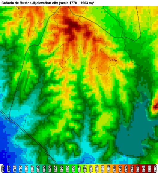
Below is the Elevation map of Cañada de Bustos, which displays elevation range with different colors. Scale of the first map is from 1770 to 1963 m (5807 to 6440 ft) with average elevation of 1854.8 meters (=6085 ft) [note 1]
These maps also provides idea of topography and contour of this city, they are displayed at different zoom levels. More info about maps, scale and edge coordinates you can find below images.
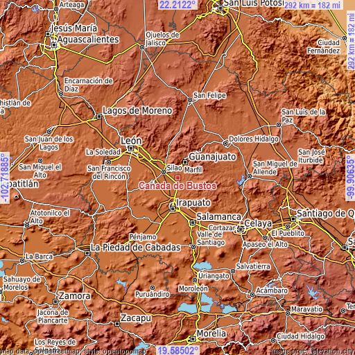
| \ | Map #1 | Topo.Map |
| Scale [m] | 1770..1963 m | × |
| Scale [ft] | 5807..6440 ft | × |
| Average | 1854.8 m = 6085 ft | × |
| Width | 9.13 km = 5.7 mi | 292.1 km = 181.5 mi |
| Height | 9.13 km = 5.7 mi | 292.1 km = 181.5 mi |
| ↑Max Latitude | 20.945407° | 22.2122° |
| Latitude at center | 20.90436° | 20.90436° |
| ↓Min Latitude | 20.863302° | 19.58502° |
| ← Min Longitude | -101.356545° | -102.71885° |
| Longitude center | -101.3126° | -101.3126° |
| →Max Longitude | -101.268655° | -99.90635° |
Nearby cities:
Cities around Cañada de Bustos sort by population:
• Yerbabuena elevation 1939 m
7.6 km,  31°
31°
• Santa Teresa 1898 m
6.2 km,  356°
356°
• San José de Llanos 1790 m
5.4 km,  176°
176°
• Puentecillas 1867 m
4.7 km,  48°
48°
• Los Rodríguez 1829 m
6.3 km,  304°
304°
• Capulín de Bustos 1830 m
2.5 km,  166°
166°
• San José de Cervera 1897 m
7.1 km,  8°
8°
• Medio Sitio 1778 m
6 km,  229°
229°
• Los Nicolases 1788 m
5.2 km,  185°
185°
• Zangarro (Zangarro Nuevo) 1878 m
6.6 km,  141°
141°
• Paso de Pirules 1876 m
5.3 km, 14°
• Fraccionamiento Villas de Guanajuato 1895 m
6.4 km, 13°
Multilingual:
 En español:
Cañada de Bustos elevación 1855 m.
 En France:
Cañada de Bustos élévation 1855 m.
 Auf Deutsch:
Cañada de Bustos höhe über dem Meeresspiegel ist 1855 m.

Sources and notes:
- [note 1] Map square and city borders are not equal. Map elevation data is calculated only from area inside that square.
- [src 1] Elevation data from geonames database provided with same terms of usage.
- [src 2] The elevation map of Cañada de Bustos is generated using elevation data from NASA's 3 arcsec (90m) resolution SRTM data.
- [src 3] Base (background) map © OpenStreetMap contributors tiles are generated by Geofabrik and OpenTopoMap.
Copyright & License:
This Cañada de Bustos Elevation Map is licensed under CC BY-SA. You may reuse any part from this page, if you give a proper credit by linking to this URL:
 More info on terms of use page.